Pages
-

-
Title
-
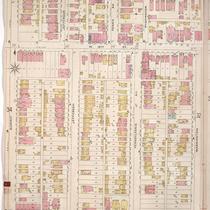
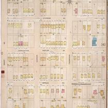
Sanborn Map, Kansas City, Vol. 2, 1896-1907, Page p141
-
Description
-
Northeastern part of early Kansas City from E. 10th Street south to E. 12th Street and from Harrison Street east to Tracy Avenue, showing buildings, streets, and additions. Large numbers at edges of page refer to page with adjoining area.
-
Date
-
1896/1907
-
Object Type
-
Map
-

-
Title
-
Oregon Trail
-
Description
-
Framed (26.5 in. x 17.5 in.) and matted giclée print "The Oregon Trail; The Highway of the Pioneers to the Pacific Northwest." The print is a reproduction from a map in the MVSC map collection by W. F. McIlwraith.
-
Date
-
2006~
-
Object Type
-
Archival Material
-

-
Title
-
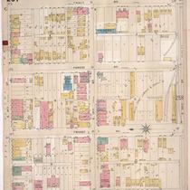
Sanborn Map, Kansas City, Vol. 2, 1909-1937, Page p214
-
Description
-
A portion of Kansas City from E. 8th Street south to E. 11th Street and from Harrison Street east to Forest Avenue, showing buildings, streets, and additions. Large numbers at edges of page refer to page with adjoining area.
-
Date
-
1909/1937
-
Object Type
-
Map
-

-
Title
-
Art Is Happening
-
Description
-
Three-dimensional map of the River Quay or River Market area of Downtown, with a description of the Crown Center Art Festival held there.
-
Date
-
1974-05-15
-
Object Type
-
Newspaper Article
-

-
Title
-
The City of Saint Louis and Its Resources
-
Description
-
Map of rail lines owned and operated by the Wiggins Ferry Company in Saint Louis, also showing streets and creeks along the Missouri River in the vicinity of the city.
-
Date
-
1893
-
Object Type
-
Book
-
-
Title
-
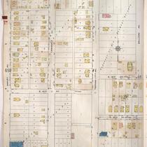
Sanborn Map, Kansas City, Vol. 1, 1895-1907, Page p031
-
Description
-
North central part of early Kansas City in the Crossroads Arts District from W. 15th Street south to W. 17th Street and from Summit Street east to Washington Street. Large numbers at edges of page refer to page with adjoining area.
-
Date
-
1895/1907
-
Object Type
-
Map
-
-
Title
-
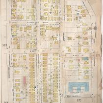
Sanborn Map, Kansas City, Vol. 3, 1896-1907, Page p257
-
Description
-
Southeastern part of early Kansas City from E. 18th Street south to E. 20th Street and from Harrison Street east to Tracy Avenue, showing buildings, streets, and additions. Large numbers at edges of page refer to page with adjoining area.
-
Date
-
1896/1907
-
Object Type
-
Map
-

-
Title
-
Sanborn Map, Kansas City, Vol. 2, 1909-1937, Page p178
-
Description
-
A portion of Kansas City from Pacific south to Indendence Avenue and from Lydia Avenue east to Highland Avenue, showing buildings, streets, and additions. Large numbers at edges of page refer to page with adjoining area.
-
Date
-
1909/1937
-
Object Type
-
Map
-

-
Title
-
Sanborn Map, Kansas City, Vol. 5, 1909-1938, Page p624
-
Description
-
A portion of Kansas City from Norledge Avenue south to Saint John Avenue and from N. Hardesty Avenue east to N. Oakley Avenue, showing buildings, streets, and additions. Large numbers at edges of page refer to page with adjoining area.
-
Date
-
1909/1938
-
Object Type
-
Map
-

-
Title
-
Sanborn Map, Kansas City, Vol. 6, 1917-1945, Page p812
-
Description
-
A portion of western Kansas City from E. 55th Street south to E. 57th Street and from Main Street east to Brookside Boulevard, showing buildings, streets, and additions. Large numbers at edges of page refer to page with adjoining area.
-
Date
-
1917/1945
-
Object Type
-
Map
-
-
Title
-
Sanborn Map, Kansas City, Vol. 5, 1909-1938, Page p659
-
Description
-
A portion of Kansas City from E. 12th Street south to E. 15th Street and from Oakley Avenue east to Bellaire Avenue, showing buildings, streets, and additions. Large numbers at edges of page refer to page with adjoining area.
-
Date
-
1909/1938
-
Object Type
-
Map
-

-
Title
-
Sanborn Map, Kansas City, Vol. 6, 1917-1957, Page p812
-
Description
-
A portion of Kansas City from E. 55th Street south to E. 57th Street and from Main Street east to Brookside Boulevard, showing buildings, streets, and additions. Large numbers at edges of page refer to page with adjoining area.
-
Date
-
1917/1957
-
Object Type
-
Map
-

-
Title
-
Sanborn Map, Kansas City, Vol. 5, 1909-1938, Page p685
-
Description
-
A portion of Kansas City from E. 27th Street south to E. 29th Street and from Cleveland Avenue east to Norton Avenue, showing buildings, streets, and additions. Large numbers at edges of page refer to page with adjoining area.
-
Date
-
1909/1938
-
Object Type
-
Map
-
-
Title
-
Sanborn Map, Kansas City, Vol. 4, 1909-1950, Page p556
-
Description
-
A portion of Kansas City from W. 43rd Street south to W. 44th Street Terrace and from Pennsyvlania Avenue east to Wornall Road, showing buildings, streets, and additions. Large numbers at edges of page refer to page with adjoining area.
-
Date
-
1909/1950
-
Object Type
-
Map
-

-
Title
-
Sanborn Map, Kansas City, Vol. 4, 1909-1950, Page p535
-
Description
-
A portion of Kansas City from E. 39th Street south to E. 40th Street and from Forest Avenue east to Flora Avenue, showing buildings, streets, and additions. Large numbers at edges of page refer to page with adjoining area.
-
Date
-
1909/1950
-
Object Type
-
Map
-

-
Title
-
Sanborn Map, Kansas City, Vol. 5, 1909-1938, Page p669
-
Description
-
A portion of Kansas City from E. 17th Street south to E. 20th Street and from Cleveland Avenue east to Norton Avenue, showing buildings, streets, and additions. Large numbers at edges of page refer to page with adjoining area.
-
Date
-
1909/1938
-
Object Type
-
Map
-

-
Title
-
Sanborn Map, Kansas City, Vol. 1, 1939-1958, Page p083
-
Description
-
A portion of Kansas City from E. 14th Street south to Truman Road and from Tracy Avenue east to The Paseo, showing buildings and streets. Large numbers at edges of page refer to page with adjoining area.
-
Date
-
1939/1958
-
Object Type
-
Map
-
-
Title
-
Sanborn Map, Kansas City, Vol. 3, 1896-1907, Page p339
-
Description
-
Northeastern part of early Kansas City from Smart Avenue south to Thompson Street and from Jackson Avenue east to Cypress Avenue, showing buildings, streets, and additions. Large numbers at edges of page refer to page with adjoining area.
-
Date
-
1896/1907
-
Object Type
-
Map
-

-
Title
-
Sanborn Map, Kansas City, Vol. 4, 1909-1957, Page p568
-
Description
-
A portion of Kansas City from E. 31st Street south to E. 33rd Street and from Agnes Avenue east to College Avenue, showing buildings, streets, and additions. Large numbers at edges of page refer to page with adjoining area. At top of page, "Add'l Sheet, May 1912."
-
Date
-
1909/1957
-
Object Type
-
Map
Pages
