Pages
-

-
Title
-
An Experiment in Counterinsurgency: The Assessment of Confederate Sympathizers in Missouri
-
Description
-
Article about the attempts by the Union military to battle guerrilla warfare and other Confederate sympathizing activities in Civil War Missouri through tax assessments on "disloyal citizens." Various aspects through the war of these programs are discussed in various parts of the state, along with mention of many prominent politicians and military officers and Bushwhackers involved.
-
Date
-
1969-08-01
-
Object Type
-
Magazine Article
-

-
Title
-
Southeast High School
-
Description
-
File containing miscellaneous newspaper clippings and a September 19, 1960 dedication program.
-
Object Type
-
Vertical File
-

-
Title
-
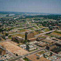
Southeast from Commerce Tower
-
Description
-
View facing southeast taken from the Commerce Towers Building at 911 Main Street. The Richard Bolling Federal Building, Jackson County Courthouse, City Hall, the Southwestern Bell Telephone Building, and other downtown buildings can be seen.
-
Date
-
1966-05-04
-
Object Type
-
Photograph
-

-
Title
-
Southeast Trafficway Dedication
-
Description
-
View facing northwest that captures the dedication ceremony for the Southeast Trafficway. Mayor H. Roe Bartle is addressing the crowd. Audience members, members of the media, a downtown building under construction, and City Hall can also be seen.
-
Date
-
1962-08-17
-
Object Type
-
Photograph
-

-
Title
-
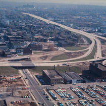
Skyline from Southeast Trafficway
-
Description
-
View facing northwest that captures the downtown Kansas City, Missouri, skyline, taken from the southeast corner of the downtown expressway loop. City Hall, St. Mary's Episcopal Church, the Jackson County Courthouse, and other downtown buildings can be seen. Construction of Highway 71 is also in view.
-
Date
-
1962-10-14
-
Object Type
-
Photograph
-

-
Title
-
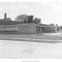
Southeast Community Center
-
Description
-
View of Southeast Community Center, located at 3601 E. 63rd St.
-
Object Type
-
Photograph
-

-
Title
-
Southeast Community Center
-
Description
-
View of Southeast Community Center, located at 3601 E. 63rd St.
-
Object Type
-
Photograph
-

-
Title
-
Southeast Motor Company
-
Description
-
Full frontal view of Southeast Motor Company; located at 16th and Grand Avenue.
-
Date
-
1920
-
Object Type
-
Photograph
-

-
Title
-
Southeast High School
-
Description
-
Partial frontal view; located at 3500 E. Meyer Boulevard.
-
Date
-
1950
-
Object Type
-
Photograph
-
-
Title
-
6th and Southeast Trafficway
-
Description
-
View facing northeast taken from City Hall located at 414 E. 12th Street. The Chase Hotel, the northeast corner of the downtown expressway loop, Columbus Park, the Missouri River, and other downtown buildings can be seen.
-
Date
-
1961-09-07
-
Object Type
-
Photograph
-
-
Title
-
Southeast Community Center
-
Description
-
View of Southeast Community Center, located at 3601 E. 63rd St.
-
Date
-
1956-07
-
Object Type
-
Photograph
-

-
Title
-
Sore Spot for Southeast
-
Description
-
Residents of Hickman Mills, Ruskin Heights, and other southeast Kansas City neighborhoods are disheartened by reports that Kansas City Wizards ownership will likely back out of a plan to build new soccer stadium at the old Bannister Mall site. A new proposal calls for construction of a stadium and Cerner Corporation office complex near the Kansas Speedway in Wyandotte County.
-
Date
-
2009-09-12
-
Object Type
-
Newspaper Article
-
-
Title
-
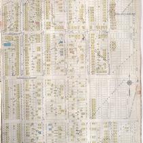
Sanborn Map, Kansas City, Vol. 6, 1917-1945, Page p828
-
Description
-
A portion of Kansas City from E. 35th Street south to E. 38th Street and from Indiana Avenue east to Myrtle Avenue, showing buildings, streets, and additions. Large numbers at edges of page refer to page with adjoining area.
-
Date
-
1917/1945
-
Object Type
-
Map
-

-
Title
-
Libraries--Missouri--Southeast Missouri State
-
Description
-
Photos and information on the Kent Library at Southeast Missouri State Teachers College (later Southeast Missouri State University), built in 1939 in Cape Girardeau, Missouri.
-
Object Type
-
Vertical File
-
-
Title
-
Southeast Trafficway from City Hall
-
Description
-
View facing east taken from City Hall at 414 E. 12th Street. The southeast corner of the downtown expressway loop under construction and downtown buildings can be seen.
-
Date
-
1961-11-06
-
Object Type
-
Photograph
-

-
Title
-
Southeast Trafficway Dedication - Ribbon Cutting
-
Description
-
View of a crowd attending a ribbon cutting ceremony for the Southeast Trafficay. Mrs. Whitton, wife of Federal Highway Administrator Rex M. Whitton is cutting the ribbon. Rex M. Whitton, Independence Mayor L. F. P. Curry, Missouri Governor John M. Dalton, President Harry S. Truman, and Raytown Mayor John D. Fox can also be seen.
-
Date
-
1962-08-17
-
Object Type
-
Photograph
-

-
Title
-
Bombay's Away
-
Description
-
Review of Touch of Asia.
-
Date
-
2001-05-03
-
Object Type
-
Newspaper Article
Pages
