-

-
Title
-
Aerial View of Kansas City, Missouri
-
Description
-
Aerial photograph of one square mile of Kansas City, Missouri showing Swope Parkway, Meyer Boulevard, Southeast High School, and the edge of Swope Park. Map identified from set as Section 3, Township 48N, Range 33W, S-105.
-
Date
-
1964-04
-
Object Type
-
Map
-

-
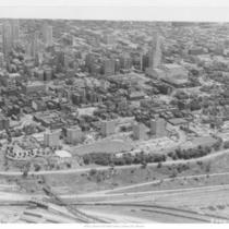
Title
-
Downtown Kansas City
-
Description
-
Looking southeast, from the Missouri River.
-
Date
-
1950
-
Object Type
-
Photograph
-

-
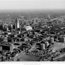
Title
-
Downtown Kansas City
-
Description
-
Looking southeast, from 9th and Main.
-
Date
-
1955
-
Object Type
-
Photograph
-

-
Title
-
Kansas City, Missouri
-
Description
-
Looking southeast, near 12th and Main.
-
Date
-
1900
-
Object Type
-
Photograph
-

-
Title
-
Downtown Kansas City
-
Description
-
Looking southeast from north end of West Bottoms.
-
Date
-
1959
-
Object Type
-
Photograph
-
-
Title
-
Downtown Kansas City
-
Description
-
Looking southeast, near Beardsley Bluff and Pennsylvania.
-
Date
-
1955
-
Object Type
-
Photograph
-

-
Title
-
Downtown Kansas City
-
Description
-
Looking southeast, near 6th Street Trafficway and Central.
-
Date
-
1940
-
Object Type
-
Photograph
-

-
Title
-
Downtown Independence
-
Description
-
Aerial view of downtown area looking southeast.
-
Object Type
-
Photograph
-

-
Title
-
Garage Construction
-
Description
-
Aerial construction view looking southeast; lot located between 12th and 13th and Wyandotte and Central.
-
Date
-
1953
-
Object Type
-
Photograph
-

-
Title
-
1951 Flood
-
Description
-
Aerial view of flooded area looking southeast across the Fairax District. Downtown skyline, Municipal Airport, General Motors assembly plant, and Phillips Refinery in view.
-
Date
-
1951
-
Object Type
-
Photograph
-

-
Title
-
U.S. 169 and Barry Road
-
Description
-
Aerial view of the southeast corner of the intersection of U.S. 169 Highway and Barry Road. A section is outlined in red ink.
-
Object Type
-
Photograph
-

-
Title
-
U.S. 169 Highway and Barry Road
-
Description
-
Aerial view of the intersection of U.S. 169 Highway and Barry Road. Southeast corner is outlined in red ink. Directions are marked in ink on photo margins.
-
Object Type
-
Photograph
-

-
Title
-
U.S. 169 Highway and Barry Road
-
Description
-
Aerial view of the intersection of U.S. 169 Highway and Barry Road. The southeast corner of the intersection is outlined in red ink; directions are marked in ink on margins.
-
Object Type
-
Photograph
-

-
Title
-
Intercity Viaduct
-
Description
-
Aerial view looking southeast over the Intercity Viaduct and northern part of West Bottoms. Distant view of downtown Kansas City in the top with Quality Hill area and 8th Street Tunnel entrance.
-
Date
-
1930~
-
Object Type
-
Photograph