-

-
Title
-
Sanborn Map, Kansas City, Vol. 6, 1917-1945, Page p828
-
Description
-
A portion of Kansas City from E. 35th Street south to E. 38th Street and from Indiana Avenue east to Myrtle Avenue, showing buildings, streets, and additions. Large numbers at edges of page refer to page with adjoining area.
-
Date
-
1917/1945
-
Object Type
-
Map
-

-
Title
-
Sanborn Map, Kansas City, Vol. 6, 1917-1957, Page p754
-
Description
-
Portions of Kansas City showing Midwest Research Laboratories and Southeast High School, including streets and additions. Large numbers at edges of page refer to page with adjoining area. At top of page, "'NA' Apr. 1956."
-
Date
-
1917/1957
-
Object Type
-
Map
-
-
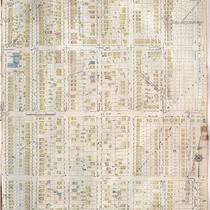
Title
-
Sanborn Map, Kansas City, Vol. 6, 1917-1957, Page p828
-
Description
-
A portion of Kansas City from E. 35th Street south to E. 38th Street and from Indiana Avenue east to Myrtle Avenue, showing buildings, streets, and additions. Large numbers at edges of page refer to page with adjoining area. Noted at top of page, "New Sheet Dec. 1931."
-
Date
-
1917/1957
-
Object Type
-
Map
-

-
Title
-
Sanborn Map, Kansas City, Vol. 6, 1917-1957, Page p752
-
Description
-
A portion of Kansas City from E. 42nd Street south to E. 45th Street and from Myrtle Avenue east to Elmwood, showing buildings, streets, and additions. Large numbers at edges of page refer to page with adjoining area. Update at top of page reads "'NA' June 1941."
-
Date
-
1917/1957
-
Object Type
-
Map
-

-
Title
-
Sanborn Map, Kansas City, Vol. 6, 1917-1945, Page p752
-
Description
-
A portion of northeastern Kansas City, Missouri, from E. 42nd Street south to E. 45th Street and from Myrtle Avenue east to Elmwood Avenue, showing buildings, streets, and additions. Large numbers at edges of page refer to page with adjoining area.
-
Date
-
1917/1945
-
Object Type
-
Map
-

-
Title
-
Sanborn Map, Kansas City, Vol. 6, 1917-1957, Page p792
-
Description
-
A portion of eastern Kansas City from E. 67th Street south to E. 69th Street and from Myrtle Avenue east to Elmwood Avenue, showing buildings, streets, and additions. Separate sections show Hillcrest Country Club, George H. Nettleton Home for Aged Ladies, Park Gate, Associated Lumber and Millwork Company, and Blue Ridge Park. Large numbers at edges of page refer to page with adjoining area.
-
Date
-
1917/1957
-
Object Type
-
Map
-

-
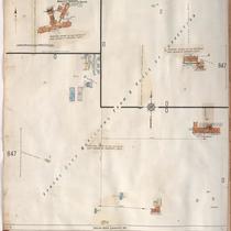
Title
-
Sanborn Map, Kansas City, Vol. 6, 1917-1945, Page p847
-
Description
-
A portion of the Kansas City Municipal Farm and House of Corrections, located 1.5 miles southeast of Leeds, Missouri, showing buildings and streets. Large numbers at edges of page refer to page with adjoining area.
-
Date
-
1917/1945
-
Object Type
-
Map
-
-
Title
-
Sanborn Map, Kansas City, Vol. 6, 1917-1957, Page p847
-
Description
-
A portion of the Kansas City Municipal Farm and House of Corrections, located 1.5 miles southeast of Leeds, Missouri, showing buildings and streets. Large numbers at edges of page refer to page with adjoining area.
-
Date
-
1917/1957
-
Object Type
-
Map
-

-
Title
-
Sanborn Map, Kansas City, Vol. 6, 1917-1945, Page p792
-
Description
-
A portion of eastern Kansas City from E. 67th Street south to E. 69th Street and from Myrtle Avenue east to Elmwood Avenue, showing buildings, streets, and additions. Sections showing Hillcrest Country Club, George H. Nettleton Home for Aged Ladies, Park Gate, Union Bridge and Construction Company, and Blue Ridge Park are also included on this sheet. Large numbers at edges of page refer to page with adjoining area.
-
Date
-
1917/1945
-
Object Type
-
Map
