Pages
-

-
Title
-
Southeast High School
-
Description
-
Partial exterior view of Southeast High School located at 3500 E. Meyer Boulevard.
-
Object Type
-
Photograph
-

-
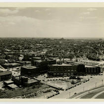
Title
-
Southeast from Commerce Tower
-
Description
-
View facing southeast taken from the Commerce Towers Building at 911 Main Street. The Richard Bolling Federal Building, Jackson County Courthouse, City Hall, the Southwestern Bell Telephone Building, and other downtown buildings can be seen.
-
Date
-
1966-05-04
-
Object Type
-
Photograph
-

-
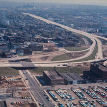
Title
-
Southeast Trafficway Dedication
-
Description
-
View facing northwest that captures the dedication ceremony for the Southeast Trafficway. Mayor H. Roe Bartle is addressing the crowd. Audience members, members of the media, a downtown building under construction, and City Hall can also be seen.
-
Date
-
1962-08-17
-
Object Type
-
Photograph
-

-
Title
-
Skyline from Southeast Trafficway
-
Description
-
View facing northwest that captures the downtown Kansas City, Missouri, skyline, taken from the southeast corner of the downtown expressway loop. City Hall, St. Mary's Episcopal Church, the Jackson County Courthouse, and other downtown buildings can be seen. Construction of Highway 71 is also in view.
-
Date
-
1962-10-14
-
Object Type
-
Photograph
-

-
Title
-
Southeast Community Center
-
Description
-
View of Southeast Community Center, located at 3601 E. 63rd St.
-
Object Type
-
Photograph
-

-
Title
-
Southeast High School
-
Description
-
View of the front of Southeast High School, located at 3500 E. Meyer Boulevard.
-
Object Type
-
Photograph
-

-
Title
-
Southeast Community Center
-
Description
-
View of Southeast Community Center, located at 3601 E. 63rd St.
-
Object Type
-
Photograph
-
-
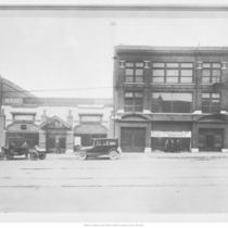
Title
-
Southeast Motor Company
-
Description
-
Full frontal view of Southeast Motor Company; located at 16th and Grand Avenue.
-
Date
-
1920
-
Object Type
-
Photograph
-

-
Title
-
Southeast High School
-
Description
-
Partial frontal view; located at 3500 E. Meyer Boulevard.
-
Date
-
1950
-
Object Type
-
Photograph
-
-
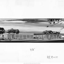
Title
-
Southeast Junior High School
-
Description
-
Architectural drawing for Southeast Junior High School. Architects: Keene & Simpson & Murphy.
-
Date
-
1960~
-
Object Type
-
Photograph
-

-
Title
-
6th and Southeast Trafficway
-
Description
-
View facing northeast taken from City Hall located at 414 E. 12th Street. The Chase Hotel, the northeast corner of the downtown expressway loop, Columbus Park, the Missouri River, and other downtown buildings can be seen.
-
Date
-
1961-09-07
-
Object Type
-
Photograph
-

-
Title
-
Southeast Community Center
-
Description
-
View of Southeast Community Center, located at 3601 E. 63rd St.
-
Date
-
1956-07
-
Object Type
-
Photograph
-
-
Title
-
Southeast Trafficway from City Hall
-
Description
-
View facing east taken from City Hall at 414 E. 12th Street. The southeast corner of the downtown expressway loop under construction and downtown buildings can be seen.
-
Date
-
1961-11-06
-
Object Type
-
Photograph
-

-
Title
-
Southeast Trafficway Dedication - Ribbon Cutting
-
Description
-
View of a crowd attending a ribbon cutting ceremony for the Southeast Trafficay. Mrs. Whitton, wife of Federal Highway Administrator Rex M. Whitton is cutting the ribbon. Rex M. Whitton, Independence Mayor L. F. P. Curry, Missouri Governor John M. Dalton, President Harry S. Truman, and Raytown Mayor John D. Fox can also be seen.
-
Date
-
1962-08-17
-
Object Type
-
Photograph
-
-
Title
-
View Southeast from the Liberty Memorial
-
Description
-
View looking southeast from the top of the Liberty Memorial tower. Portions of Main Street, Grand Avenue, and 26th Street are in view. Several buildings that once stood in the area can be seen. Signs for REO Sales Corporation, Mack Trucks, Buick, Edward Stewart Motor Repair, Allison's Super Service, Sheaffer's Pen & Pencil, Greiner-Fofoeld Commercial Lithography, Gordon Brothers Manufacturing Company, Hudson-Brace Motor Company, and Chevrolet are in view. The Hall Brothers Building can be seen left of center in the image. Several cars parked and traveling along the streets can be seen.
-
Date
-
1935~
-
Object Type
-
Photograph
-

-
Title
-
Southeast Corner 46th Street and Pennsylvania Avenue
-
Description
-
View of the southeast corner of the intersection of 46th Street and Pennsylvania Avenue in the Country Club Plaza. The label on the photograph misidentifies the image as the southwest corner. Apartment buildings that one stood along the east side of Pennsylvania Avenue and a portion of the Country Club Apartments can be seen. Several cars parked along the street can be seen.
-
Date
-
1950~
-
Object Type
-
Photograph
-

-
Title
-
Pennsylvania Avenue Looking Southeast from Archibald Avenue
-
Description
-
View of Pennsylvania Avenue facing southeast from Archibald Avenue in Westport. A sign for Blake Sheet Metal Works and the Plaza Laundry Building are in view on the west side of the street. Several cars in a parking lot and parked along Pennsylvania Avenue can be seen.
-
Date
-
1950~
-
Object Type
-
Photograph
Pages


