-

-
Title
-
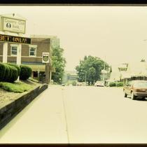
Wyandotte Street
-
Description
-
Intersection of Wyandotte Street and 14th Street Trafficway in winter. View shows the southeast corner of the intersection on the left.
-
Date
-
1955
-
Object Type
-
Photograph
-

-
Title
-
B'nai Jehudah Temple
-
Description
-
An autochrome photograph of the B'nai Jehudah Temple, a Jewish synagogue at the southeast corner of Flora Avenue and Linwood Boulevard. This vantage point faces south on Linwood Boulevard just east of Flora.
-
Date
-
1933-10-04
-
Object Type
-
Photograph
-
-
Title
-
44th and Belleview Intersection
-
Description
-
Photograph at the intersection of 44th Street and Belleview Avenue, looking south on Belleview, circa 1986. A sign for Country Club Bank stands on the northeast corner of the intersection, and The Point bar on the southeast corner. Houses line the west side of the street.
-
Date
-
1980~/1989~
-
Object Type
-
Photograph
-

-
Title
-
Northeast Corner of 47th and Main
-
Description
-
Photograph of the northeast corner of 47th and Main Streets circa 1980. Seen from near the southeast corner of the intersection, the rear of the Community Christian Church can be seen across 47th Street and a Country Club Plaza employee parking lot. The Parkway Towers apartment building can be seen in the background at left, and the Ponce de Leon Apartments in the background at right.
-
Date
-
1980~
-
Object Type
-
Photograph
-

-
Title
-
Intersection of Ward Parkway and 48th Street
-
Description
-
Photograph of the intersection of 48th Street and Ward Parkway, looking southeast along 48th Street, in the early 1980s. The Raphael Hotel, formerly the Villa Serena Apartments, at 321 Ward Parkway, is pictured at right. The Regency House Apartments occupy the center of the image, and the Locaro Apartments building, at 235 Ward Parkway, is pictured at left.
-
Date
-
1980~/1989~
-
Object Type
-
Photograph
-

-
Title
-
4400 Block of Belleview Avenue
-
Description
-
Photograph of the 4400 block of Belleview Avenue, looking north toward 44th Street, circa 1986. A house at 4418 Belleview is visible at the left edge of the image, and building housing The Point bar can be seen at right, on the southeast corner of 44th and Belleview.
-
Date
-
1986~
-
Object Type
-
Photograph
-

-
Title
-
Southmoreland and Plaza Buildings
-
Description
-
Photograph, looking southeast from the top of the Fountain View (later American Century Investments north tower), across 47th Street toward the UMKC campus circa 1987. The Hilton Plaza Inn, at 1 West 45th, occupies the bottom left corner of the image, and numerous residential buildings are pictured lining 47th Street. Streetcar tracks can be seen running behind commercial buildings in the foreground, south diagonally across Main Street, before running alongside Brookside Boulevard south of Brush Creek. Main Street and Brookside Boulevard were later realigned as part of a Brush Creek beautification and flood control project in the 1990s.
-
Date
-
1987~
-
Object Type
-
Photograph
-

-
Title
-
Main Street and J. C. Nichols Parkway at 47th Street
-
Description
-
Photograph, looking south from the top of the Fountain View (later American Century Investments north tower), toward the intersection of 47th Street with J. C. Nichols Parkway (at right) and Main Street (at left). Streetcar tracks can be seen running behind commercial buildings in the foreground, southeast diagonally across Main Street. Nichols Fountain, in Mill Creek Park, is visible at the center of the image. Main Street and Brookside Boulevard were later realigned as part of a Brush Creek beautification and flood control project in the 1990s. South Plaza apartment and office buildings are visible in the background of the image, with Country Club Plaza commercial and residential buildings in the foreground right.
-
Date
-
1980~/1989~
-
Object Type
-
Photograph
-
-
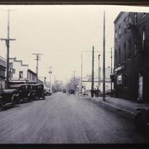
Title
-
Intersection of Westport & Pennsylvania
-
Description
-
Photograph of the intersection of Westport Road and Pennsylvania Avenue circa 1923. Wiedenmann Brothers Grocery Store, at 500 Westport Road, can be seen on the northwest corner of the intersection, and Doerschuk's Prescription Drug Store, at 501 Westport, is on the southwest corner. Signs reading "Mogul Overalls" hang on the building at 433 Westport, on the southeast corner, which was the home to Klein's clothing store. The northeast corner, a vacant lot at the time of the photo, was the original location of the pre-Civil War Harris-Kearney House, a hotel and later a private home, which was moved to a location several blocks away in 1922. It was replaced by a commercial building shortly thereafter.
-
Date
-
1923~
-
Object Type
-
Photograph

