Pages
-

-
Title
-
100 - 108 Garfield Avenue
-
Description
-
Photograph, looking southeast, circa 1980s of homes on the west side of the 100 block of Garfield Avenue. On the far right is the Flavel B. Tiffany residence, designed by architect Clifton B. Sloan and built in 1909, known as the "Tiffany Castle" at 100 Garfield Avenue. To the south, in the middle of the photo, is the single family home at 106 Garfield Avenue, built in 1894. Further south, partially visible, is the single family home at 108 Garfield Avenue, built in 1968. These homes were placed on the Kansas City Register of Historic Places as part of the Pendleton Heights Historic District in 1992. Located in the Pendleton Heights neighborhood.
-
Date
-
1980~/1989~
-
Object Type
-
Photograph
-
-
Title
-
101-03 East 40th Street
-
Description
-
Photograph of apartment buildings at the southeast corner of 40th and Walnut Streets, including Merton Hall at 101 East 40th Street, circa 1980. Merton Hall, and the Elmore Apartments building to the east, are eight-plex Kansas City Colonnade buildings, with columned porches at their fronts, built in the early 1920s. Merton Hall suffered a major fire in April 1983, and was torn down a week later. The others buildings in view in the image were later also demolished and the property used by the neighboring St. Paul's Episcopal Church as sports fields and gardens.
-
Date
-
1980~
-
Object Type
-
Photograph
-

-
Title
-
106-108 Garfield Avenue
-
Description
-
Photograph, looking southeast, circa 1980s of two homes on the west side of the 100 block of Garfield Avenue. On the far right is 106 Garfield Avenue, built in 1894, that has served as both a single family home and a duplex. Further south is the single family home at 108 Garfield Avenue, built in 1968. These homes were placed on the Kansas City Register of Historic Places as part of the Pendleton Heights Historic District in 1992.
-
Date
-
1980~/1989~
-
Object Type
-
Photograph
-

-
Title
-
10th and Baltimore
-
Description
-
View of the southeast corner of 10th and Baltimore showing the old New England Bank building (H. O. Peet & Co.), Land Bank building, and First National Bank building.
-
Date
-
1940~/1959~
-
Object Type
-
Photograph
-
-
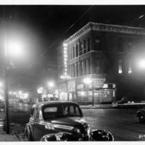
Title
-
12th Street
-
Description
-
Looking southeast from the northwest corner of 12th and Holmes streets at night. The Marquette Hotel and the Paramount Tavern can be seen.
-
Date
-
1946
-
Object Type
-
Photograph
-

-
Title
-
12th Street
-
Description
-
Looking west along 12th from the southeast corner of 12th and Main.
-
Date
-
1946
-
Object Type
-
Photograph
-
-
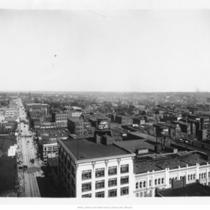
Title
-
12th Street
-
Description
-
Skyline view looking southeast from roof of the Baltimore Hotel, 12th and Baltimore.
-
Date
-
1900
-
Object Type
-
Photograph
-

-
Title
-
14th Street
-
Description
-
Looking northwest from the southeast corner of 14th and Lydia.
-
Date
-
1965
-
Object Type
-
Photograph
-

-
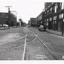
Title
-
18th and Grand Looking East
-
Description
-
View facing east along 18th Street from its intersection with Grand Avenue. The Grand Avenue Bank Building can be seen on the south side of the street. A sign for an unidentified restaurant reading Jerry's can be seen on the south side of the street. Sings for the Central Pontiac automobile dealership attached to the building on the southeast corner of 18th and McGee streets can be seen. Cars and pedestrians along 18th Street are in view.
-
Date
-
1948-07-16
-
Object Type
-
Photograph
-
-
Title
-
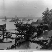
1903 Flood
-
Description
-
1903 Flood scene, homes flooded and smokestacks across the river in view, exact location unknown. Identified as “Flood of 1903â€. May be looking southeast across the Kansas River.
-
Date
-
1903
-
Object Type
-
Photograph
-
-
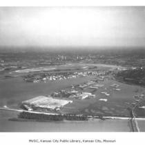
Title
-
1951 Flood
-
Description
-
Aerial view of flooded area looking southeast across the Fairax District. Downtown skyline, Municipal Airport, General Motors assembly plant, and Phillips Refinery in view.
-
Date
-
1951
-
Object Type
-
Photograph
-
-
Title
-
19th and Grand Looking East
-
Description
-
View facing east along 19th Street from its intersection with Grand Avenue. Signs for the Berry Berl automobile dealership attached to the building on the southeast corner of 19th and McGee streets can be seen. Cars and trucks along 19th Street are in view. A bicyclist on the north side of the street can be seen.
-
Date
-
1948-07-16
-
Object Type
-
Photograph
-
-
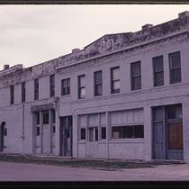
Title
-
2100 Harrison Street
-
Description
-
Photograph of a commercial building at the southeast corner of 21st and Harrison. The building was later demolished to make way for the construction of 71 Highway/Bruce R. Watkins Drive in the 1990s.
-
Date
-
1980~/1989~
-
Object Type
-
Photograph
-

-
Title
-
2535 Guinotte Avenue
-
Description
-
Photograph, looking southeast, circa 1980s of a Firestone gas station at 2535 Guinotte Avenue, owned by Maher Oil Company. The building sits at the intersection of the Guinotte Viaduct and N Prospect Avenue, facing north.
-
Date
-
1980~/1989~
-
Object Type
-
Photograph
-

-
Title
-
31st & Main Streets
-
Description
-
Photograph of the intersection of 31st and Main Streets in the early 1980s, including the Jeserich Building on the northeast corner of the intersection. Protective fencing blocks the Jeserich building, and Ward Building to its north at 3037 Main, from Main Street. A bar at 3039 Main, Mike's Kitchen, has a spraypainted notice that it is relocating to 63rd & Troost. The building occupied by the bar, and the building immediately to its north, were demolished shortly thereafter. The Hadassah Bargain Center thrift shop stands at the southeast corner of the intersection. The building it occupies was demolished in 1990 to make way for a new development project.
-
Date
-
1980~/1989~
-
Object Type
-
Photograph
-
-
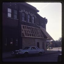
Title
-
3200 Independence Avenue
-
Description
-
Photograph circa 1980s looking southeast, of the Benton Theater building that was at 3200 Independence Avenue, on the northeast corner of Independence Avenue and Benton Boulevard. It was built ca. 1911 and served as a church after the theater closed in 1952. It was demolished in 2015, after the roof collapsed in 2014. In the Scarritt Point neighborhood.
-
Date
-
1980~/1989~
-
Object Type
-
Photograph
-

-
Title
-
3200 Independence Avenue
-
Description
-
Photograph circa 1980s looking southeast, of the Benton Theater building that was at 3200 Independence Avenue, on the northeast corner of Independence Avenue and Benton Boulevard. It was built ca. 1911 and served as a church after the theater closed in 1952. It was demolished in 2015, after the roof collapsed in 2014. In the Scarritt Point neighborhood.
-
Date
-
1980~/1989~
-
Object Type
-
Photograph
Pages