Pages
-

-
Title
-
Historic Kansas City Architecture
-
Description
-
Photos and captions for the interior and exterior of Union Station, "[a]ccepted to the National Register of Historic Places."
-
Date
-
1975
-
Object Type
-
Book
-

-
Title
-
End of the Line for Union Station?
-
Description
-
Article about the "inevitable departure of The [sic] Kansas City Terminal Raily Co. from Union Station." Discussion of other uses for the "oversized terminal building," including a "Science Museum" and aquarium.
-
Date
-
1983-09
-
Object Type
-
Magazine Article
-

-
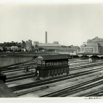
Title
-
Union Station
-
Description
-
Aerial view of Union Station and the surrounding area. Several downtown buildings are in view. Tracks for the Kansas City Terminal Railway Company can be seen behind the station. Cars parked in the station's lot and traveling along Main Street are in view.
-
Date
-
1925~
-
Object Type
-
Photograph
-

-
Title
-
Unidentified View With Building
-
Description
-
View, possibly from a train, across a field to a building presumably in Kansas City. Handwriting on photo says KC Terminal.
-
Date
-
1915~
-
Object Type
-
Photograph
-

-
Title
-
Union Station Area
-
Description
-
Aerial view of the area to the west of Union Station. Several downtown buildings are in view. The south side of the Sweeney Automobile School Building can be seen near the center of the image. The west side of Union Station is on the right had side of the image. Cars parked in the station's lot can be seen. Railroad tracks for the Kansas City Terminal Railway Company are in view.
-
Date
-
1925~
-
Object Type
-
Photograph
-
-
Title
-
Union Station - Tower 6
-
Description
-
View looking southwest of Interlocking Tower 6, once located to the east of Union Station along the Kansas City Terminal Railway tracks. Buildings once located at the intersection of Pershing Road and Main Street, the Liberty Memorial, and Union Station can be seen. Signs for the Upjohn Company, the Hotel Plaza, and Sherwin-Williams are in view.
-
Date
-
1940~
-
Object Type
-
Photograph
-
![Shiffield [sic] Yard Looking North](https://kchistory.org/sites/default/files/styles/islandora_imagecache_image_style_medium/public/externals/76ace5b4016f100fa1be49fbf24a3521.jpg?itok=eWcdcTIc&pid=kchistory:59599&iic=true&solr_nav%5Bid%5D=17c120e733e4706668a5&solr_nav%5Bpage%5D=0&solr_nav%5Boffset%5D=7)
-
Title
-
Shiffield [sic] Yard Looking North
-
Description
-
Photograph showing construction materials and buildings in the Shiffield [Sheffield] railyard. The photo is a faded duplicate of Photo #32 in the same collection.
-
Date
-
1910-11-08
-
Object Type
-
Photograph
-
![Shiffield [sic] Yard Looking North](https://kchistory.org/sites/default/files/styles/islandora_imagecache_image_style_medium/public/externals/968d885e957b817985bf585d23d0f5a7.jpg?itok=6enbPraT&pid=kchistory:59597&iic=true&solr_nav%5Bid%5D=17c120e733e4706668a5&solr_nav%5Bpage%5D=0&solr_nav%5Boffset%5D=8)
-
Title
-
Shiffield [sic] Yard Looking North
-
Description
-
Photograph showing construction materials and buildings in the Shiffield [Sheffield] railyard. It is a duplicate of Photo #31 in the same collection.
-
Date
-
1910-11-08
-
Object Type
-
Photograph
-

-
Title
-
View North from near 22nd and Holmes
-
Description
-
Panoramic view looking north from near 22nd and Holmes streets. Downtown can be seen across the Kansas City Terminal Railway tracks. Several buildings are in view, including: the Carnie-Goudie Company Building, Union Station, the Coca-Cola Company (later the Western Auto) Building, and the Firestone Building. In view are signs for: National Biscuit Company, the Studebaker Riley Company, Carey Roofing, Camel cigarettes, Franklin Ice Cream, Shuff Battery Tire & Electric Service, and the Southwest Warehouse Company.
-
Date
-
1922-05-22
-
Object Type
-
Photograph
-

-
Title
-
Station Site 24th & Main Looking West
-
Description
-
Photograph showing the corner of 24th and Main streets, looking west, after construction started on Union Station. The Terminal Warehouse and additional buildings are visible in the distance.
-
Date
-
1911-01-23
-
Object Type
-
Photograph
-

-
Title
-
Station Site 24th & Baltimore Looking West
-
Description
-
Photograph showing the corner of 24th St. and Baltimore Ave., looking west, after construction started on Union Station. Rubble from a demolished building and stumps of chopped trees have not been removed yet. The Terminal Warehouse, locomotives, tracks, and other buildings are also visible.
-
Date
-
1911-01-23
-
Object Type
-
Photograph
-

-
Title
-
View South from atop Coca-Cola Building
-
Description
-
Panoramic view looking south from the roof of the Coca-Cola (later Western Auto) building at 2107 Grand Avenue. Neighborhoods and business districts south of downtown can be seen. Several buildings are in view, including: General Hospital, General Hospital No. 2, Rahe's Automobile and Tractor (also known as the Kansas City Journal Post) Building, Schutte Lumber Company, Union Station, and the Sweeney Automobile School (later the BMA Building). In view are signs for: Oldsmobile, Holsum Bread, Melton Tire & Battery, Norwalk Tires, Kelly Tires, Racine Tires, White Rose Butter, Sunshine Biscuits, Merit Bread, Camel cigarettes, National Biscuit Company, and Folger's Coffee Company. Signboard Hill can be seen to the northwest of Union Station. The view spans the Kansas City Terminal Railway tracks, which are in view on the right hand side of the photograph.
-
Date
-
1922~
-
Object Type
-
Photograph
-

-
Title
-
Sanborn Map, Kansas City, Vol. 5, 1909-1938, Page p656
-
Description
-
A portion of Kansas City from E. 14th Street south to E. 15th Street and from Norton Avenue east to Kensington Avenue, showing buildings, streets, and additions. Large numbers at edges of page refer to page with adjoining area.
-
Date
-
1909/1938
-
Object Type
-
Map
-
-
Title
-
Sanborn Map, Kansas City, Vol. 5, 1909-1938, Page p687
-
Description
-
A portion of Kansas City from Wilson Avenue south to Winner Road and from Bennington Avenue east to Cambridge Avenue, showing buildings, streets, and additions. Large numbers at edges of page refer to page with adjoining area.
-
Date
-
1909/1938
-
Object Type
-
Map
-

-
Title
-
Sanborn Map, Kansas City, Vol. 5, 1909-1938, Page p655
-
Description
-
A portion of Kansas City from E. 12th Street south to E. 14th Street and from Norton Avenue east to Kensington Avenue, showing buildings, streets, and additions. Large numbers at edges of page refer to page with adjoining area.
-
Date
-
1909/1938
-
Object Type
-
Map
-

-
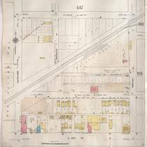
Title
-
Sanborn Map, Kansas City, Vol. 5, 1909-1938, Page p648
-
Description
-
A portion of Kansas City from E. 8th Street south to E. 10th Street and from Denver Avenue east to Hardesty Avenue, showing buildings, streets, railroads, and additions. Large numbers at edges of page refer to page with adjoining area.
-
Date
-
1909/1938
-
Object Type
-
Map
-
-
Title
-
Sanborn Map, Kansas City, Vol. 5, 1909-1938, Page p653
-
Description
-
A portion of Kansas City from E. 13th Street south to E. 15th Street and from Cleveland Avenue east to Norton Avenue, showing buildings, streets, railroads, and additions. Large numbers at edges of page refer to page with adjoining area.
-
Date
-
1909/1938
-
Object Type
-
Map
-

-
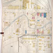
Title
-
Sanborn Map, Kansas City, Vol. 5, 1909-1938, Page p722
-
Description
-
A portion of Kansas City in the Sheffield Industrial District, showing buildings, streets, and railroads. Large numbers at edges of page refer to page with adjoining area. At the top of page, "New Sheet, May 1922."
-
Date
-
1909/1938
-
Object Type
-
Map
-

-
Title
-
Sanborn Map, Kansas City, Vol. 2, 1940-1950, Page p238
-
Description
-
A portion of northeast Kansas City from E. 11th Street south to Truman Road and from Cleveland Avenue east to Spruce Avenue, showing buildings, streets, and railroad lines. Large numbers at edges of pages refer to page with adjoining area.
-
Date
-
1940/1950
-
Object Type
-
Map
Pages
