Pages
-

-
Title
-
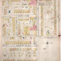
Sanborn Map, Kansas City, Vol. 3, 1909-1950, Page p380
-
Description
-
A portion of Kansas City from E. 27th Street south to Lockridge and from Prospect Avenue east to Walrond Avenue, showing buildings, streets, and additions. Large numbers at edges of page refer to page with adjoining area. Handwritten at the top of the page in red, "Negro."
-
Date
-
1909/1950
-
Object Type
-
Map
-

-
Title
-
Sanborn Map, Kansas City, Vol. 3, 1909-1950, Page p411
-
Description
-
A portion of Kansas City from Lockridge Avenue south to E. 29th Street and from Walrond Avenue east to Indiana Avenue, showing buildings, streets, and additions. Large numbers at edges of page refer to page with adjoining area.
-
Date
-
1909/1950
-
Object Type
-
Map
-
-
Title
-
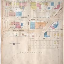
Sanborn Map, Kansas City, Vol. 3, 1909-1950, Page p388
-
Description
-
A portion of Kansas City from E. 26th Street Terrace south to Lockridge and from Agnes Avenue east to Indiana Avenue, showing buildings, streets and additions. Large numbers at edges of page refer to page with adjoining area.
-
Date
-
1909/1950
-
Object Type
-
Map
-
-
Title
-
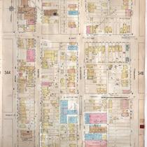
Sanborn Map, Kansas City, Vol. 3, 1909-1950, Page p346
-
Description
-
A portion of Kansas City from E. 24th Street south to E. 25th Street and from McCoy Avenue east to Campbell, showing buildings, streets, and additions. Large numbers at edges of page refer to page with adjoining area.
-
Date
-
1909/1950
-
Object Type
-
Map
-

-
Title
-
Sanborn Map, Kansas City, Vol. 3, 1909-1950, Page p365
-
Description
-
A portion of Kansas City from E. 21st Street south to E. 23rd Street and from Bales Avenue east to Cleveland Avenue, showing buildings, streets, and additions. Large numbers at edges of page refer to page with adjoining area.
-
Date
-
1909/1950
-
Object Type
-
Map
-

-
Title
-
Sanborn Map, Kansas City, Vol. 3, 1909-1950, Page p362
-
Description
-
A portion of Kansas City from E. 24th Street south to E. 25th Street and from Benton Boulevard east to Walrond Avenue, showing buildings, streets, and additions. Large numbers at edges of page refer to page with adjoining area.
-
Date
-
1909/1950
-
Object Type
-
Map
-

-
Title
-
Sanborn Map, Kansas City, Vol. 3, 1909-1950, Page p394
-
Description
-
A portion of Kansas City from E. 30th Street south to E. 31st Street and from McGee Street east to McGee Street Trafficway (Cherry), showing buildings, streets, and additions. Large numbers at edges of page refer to page with adjoining area.
-
Date
-
1909/1950
-
Object Type
-
Map
-

-
Title
-
Sanborn Map, Kansas City, Vol. 3, 1909-1950, Page p397
-
Description
-
A portion of Kansas City from E. 28th Street south to E. 29th Street and from Campbell Street east to Forest Avenue, showing buildings, streets, and additions. Large numbers at edges of page refer to page with adjoining area.
-
Date
-
1909/1950
-
Object Type
-
Map
-

-
Title
-
Sanborn Map, Kansas City, Vol. 3, 1909-1950, Page p392
-
Description
-
A portion of Kansas City from E. 30th Street south to E. 31st Street and from Main Street east to McGee Street, showing buildings, streets, and additions. Large numbers at edges of page refer to page with adjoining area.
-
Date
-
1909/1950
-
Object Type
-
Map
-

-
Title
-
Sanborn Map, Kansas City, Vol. 3, 1909-1950, Page p413
-
Description
-
A portion of Kansas City from E. 28th Street south to E. 29th Street and from Indiana Avenue east to Cleveland Avenue, showing buildings, streets, and additions. Large numbers at edges of page refer to page with adjoining area.
-
Date
-
1909/1950
-
Object Type
-
Map
-
-
Title
-
Sanborn Map, Kansas City, Vol. 3, 1909-1950, Page p393
-
Description
-
A portion of Kansas City from E. 28th Street south to McGee Street Trafficway and from Oak Street east to Cherry Street, showing buildings, streets, and additions. Large numbers at edges of page refer to page with adjoining area.
-
Date
-
1909/1950
-
Object Type
-
Map
-

-
Title
-
Sanborn Map, Kansas City, Vol. 3, 1909-1950, Page p409
-
Description
-
A portion of Kansas City from E. 29th Street south to E. 31st Street and from Prospect Avenue east to Benton Boulevard, showing buildings, streets, and additions. Large numbers at edges of page refer to page with adjoining area.
-
Date
-
1909/1950
-
Object Type
-
Map
-

-
Title
-
Sanborn Map, Kansas City, Vol. 3, 1909-1950, Page p412
-
Description
-
A portion of Kansas City from E. 29th Street south to E. 31st Street and from Walrond Avenue east to Indiana Avenue, showing buildings, streets, and additions. Large numbers at edges of page refer to page with adjoining area.
-
Date
-
1909/1950
-
Object Type
-
Map
-

-
Title
-
Sanborn Map, Kansas City, Vol. 3, 1909-1950, Page p363
-
Description
-
A portion of Kansas City from E. 21st Street south to E. 23rd Street and from College Avenue east to Bales Avenue, showing buildings, streets, and additions. Large numbers at edges of page refer to page with adjoining area.
-
Date
-
1909/1950
-
Object Type
-
Map
-

-
Title
-
Sanborn Map, Kansas City, Vol. 3, 1909-1950, Page p389
-
Description
-
A portion of Kansas City from E. 25th Street south to E. 26th Street and from Indiana Avenue east to Cleveland Avenue, showing buildings, streets, and additions. Large numbers at edges of page refer to page with adjoining area.
-
Date
-
1909/1950
-
Object Type
-
Map
-

-
Title
-
Sanborn Map, Kansas City, Vol. 3, 1909-1950, Page p366
-
Description
-
A portion of Kansas City from E. 24th Street south to E. 25th Street and from Bales Avenue east to Cleveland Avenue, showing buildings, streets, and additions. Large numbers at edges of page refer to page with adjoining area.
-
Date
-
1909/1950
-
Object Type
-
Map
-

-
Title
-
Sanborn Map, Kansas City, Vol. 3, 1909-1950, Page p382
-
Description
-
A portion of Kansas City from E. 27th Street south to E. 28th Street and from Garfield Avenue east to Olive Street, showing buildings, streets, and additions. Large numbers at edges of page refer to page with adjoining area.
-
Date
-
1909/1950
-
Object Type
-
Map
-

-
Title
-
Sanborn Map, Kansas City, Vol. 3, 1909-1950, Page p391
-
Description
-
A portion of Kansas City from E. 29th Street south to E. 30th Street and from Main Street east to McGee Street, showing buildings, streets, and additions. Large numbers at edges of page refer to page with adjoining area.
-
Date
-
1909/1950
-
Object Type
-
Map
-

-
Title
-
Sanborn Map, Kansas City, Vol. 3, 1909-1950, Page p375
-
Description
-
A portion of Kansas City from E. 25th Street south to E. 26th Street and from Forest Avenue east to The Paseo, showing buildings, streets, and additions. Large numbers at edges of page refer to page with adjoining area.
-
Date
-
1909/1950
-
Object Type
-
Map
-

-
Title
-
Sanborn Map, Kansas City, Vol. 3, 1909-1950, Page p358
-
Description
-
A portion of Kansas City from E. 24th Street south to E. 25th Street and from Park Avenue east to Prospect Avenue, showing buildings, streets, and additions. Large numbers at edges of page refer to page with adjoining area.
-
Date
-
1909/1950
-
Object Type
-
Map
Pages
