Pages
-

-
Title
-
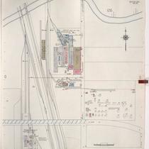
Sanborn Map, Kansas City, Vol. 5, 1940-1941, Page p1227
-
Description
-
A portion of Kansas City from E. 25th Street south to E. 26th Street and from Norton Avenue east to Kensington Avenue, showing buildings and streets. Large numbers at edges of page refer to page with adjoining area. Indicated at top of sheet that this page number corresponds with page 684 in Vol. 5, 1909-1938.
-
Date
-
1940/1941
-
Object Type
-
Map
-

-
Title
-
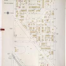
Sanborn Map, Kansas City, Vol. 5, 1940-1941, Page p1238
-
Description
-
A portion of Kansas City from E. 29th Street south to E. 31st Street and from Spruce Avenue east to York Avenue, showing buildings and streets. Large numbers at edges of page refer to page with adjoining area. Indicated at top of sheet that this page number corresponds with pages 753 and 754 in Vol. 6.
-
Date
-
1940/1941
-
Object Type
-
Map
-

-
Title
-
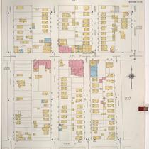
Sanborn Map, Kansas City, Vol. 5, 1940-1941, Page p0637
-
Description
-
A portion of Kansas City from Scarritt Avenue south to St. John Avenue and from N. Hardesty Avenue east to N. Lawndale Avenue, showing buildings and streets. Large numbers at edges of page refer to page with adjoining area. Indicated at top of sheet that this page number corresponds with page 624 and 625 in Vol. 5, 1909-1938.
-
Date
-
1940/1941
-
Object Type
-
Map
-

-
Title
-
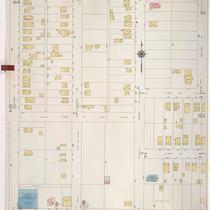
Sanborn Map, Kansas City, Vol. 5, 1940-1941, Page p1218
-
Description
-
A portion of Kansas City from E. 28th Street south to E. 31st Street and from Cleveland Avenue east to Wenzel Avenue, showing buildings and streets. Large numbers at edges of page refer to page with adjoining area. Indicated at top of sheet that this page number corresponds with page 685 in Vol. 5, 1909-1938 and page 753 in Vol. 6.
-
Date
-
1940/1941
-
Object Type
-
Map
-
-
Title
-
Sanborn Map, Kansas City, Vol. 5, 1940-1941, Page p1216
-
Description
-
A portion of Kansas City from the Big Blue River south to E. 24th Street and from the Saint Louis and San Francisco Railroad east to Tullis Avenue, showing buildings and streets. Large numbers at edges of page refer to page with adjoining area. Indicated at top of sheet that this page number corresponds with pages 707, 710 and 722 in Vol. 5, 1909-1938.
-
Date
-
1940/1941
-
Object Type
-
Map
-

-
Title
-
Sanborn Map, Kansas City, Vol. 5, 1940-1941, Page p0630
-
Description
-
A portion of Kansas City from Wilson Avenue south to E. 8th Street and from Fuller Avenue east to Winchester Avenue, showing buildings and streets. Large numbers at edges of page refer to page with adjoining area. Top of sheet indicates that this page number corresponds with pages 687, 688, 691, 692 and 693 in Vol. 5, 1909-1938.
-
Date
-
1940/1941
-
Object Type
-
Map
-

-
Title
-
Sanborn Map, Kansas City, Vol. 5, 1940-1941, Page p1212
-
Description
-
A portion of Kansas City from E. 15th Street south to E. 18th Street and from Ewing Avenue east to Crystal Avenue, showing buildings and streets. Large numbers at edges of page refer to page with adjoining area. Indicated at top of sheet that this page number corresponds with pages 697, 699, and 700 in Vol. 5, 1909-1938.
-
Date
-
1940/1941
-
Object Type
-
Map
-

-
Title
-
Sanborn Map, Kansas City, Vol. 5, 1940-1941, Page p1202
-
Description
-
A portion of Kansas City from E. 15th Street south to E. 17th Street and from Myrtle Avenue east to Jackson Avenue, showing buildings and streets. Large numbers at edges of page refer to page with adjoining area. Indicated at top of sheet that this page number corresponds with pages 663 and 664 in Vol. 5, 1909-1938.
-
Date
-
1940/1941
-
Object Type
-
Map
-

-
Title
-
Sanborn Map, Kansas City, Vol. 5, 1940-1941, Page p0645
-
Description
-
A portion of Kansas City just north of the intersection of Bristol Avenue and E. 6th Street, showing buildings, railroads and streets. Large numbers at edges of page refer to page with adjoining area. Indicated at top of sheet that this page number corresponds with pages 689, 690, and 692 in Vol. 5, 1909-1938.
-
Date
-
1940/1941
-
Object Type
-
Map
-

-
Title
-
Sanborn Map, Kansas City, Vol. 5, 1940-1941, Page p0608
-
Description
-
A portion of Kansas City from E. 12th Street Terrace south to E. 15th Street and from Ewing Avenue east to Bristol Avenue, showing buildings and streets. Large numbers at edges of page refer to page with adjoining area. Indicated at top of sheet that this page number corresponds with pages 695, 696 and 697 in Vol. 5, 1909-1938.
-
Date
-
1940/1941
-
Object Type
-
Map
-
-
Title
-
Sanborn Map, Kansas City, Vol. 5, 1940-1941, Page p0611
-
Description
-
A portion of Kansas City from Independence Avenue south to E. 9th Street and from Topping Avenue east to Fuller Avenue, showing buildings, streets, and railroads. Large numbers at edges of page refer to page with adjoining area. Indicated at top of sheet that this page number corresponds with pages 687 and 688 in Vol. 5, 1909-1938.
-
Date
-
1940/1941
-
Object Type
-
Map
-

-
Title
-
Sanborn Map, Kansas City, Vol. 5, 1940-1941, Page p1237
-
Description
-
A portion of Kansas City from E. 27th Street south to E. 29th Street and from Wenzel Avenue east to Brighton Avenue, showing buildings and streets. Large numbers at edges of page refer to page with adjoining area. Indicated at top of sheet that this page number corresponds with page 686 in Vol. 5, 1909-1938 and 753-755 in Vol. 6.
-
Date
-
1940/1941
-
Object Type
-
Map
-
-
Title
-
Sanborn Map, Kansas City, Vol. 5, 1940-1941, Page p1228
-
Description
-
A portion of Kansas City from E. 27th Street south to E. 28th Street and from Norton Avenue east to Kensington Avenue, showing buildings and streets. Large numbers at edges of page refer to page with adjoining area. Indicated at top of sheet that this page number corresponds with pages 684 and 686 in Vol. 5, 1909-1938.
-
Date
-
1940/1941
-
Object Type
-
Map
-

-
Title
-
Sanborn Map, Kansas City, Vol. 5, 1940-1941, Page p1207
-
Description
-
A portion of Kansas City from E. 15th Street south to E. 18th Street and from Cypress Avenue east to Brighton Avenue, showing buildings and streets. Large numbers at edges of page refer to page with adjoining area. Indicated at top of sheet that this page number corresponds with pages 665, 666, 671 and 672 in Vol. 5, 1909-1938.
-
Date
-
1940/1941
-
Object Type
-
Map
-

-
Title
-
Sanborn Map, Kansas City, Vol. 5, 1940-1941, Page p0628
-
Description
-
A portion of Kansas City from Anderson Avenue south to Independence Avenue and from Wheeling Avenue east to Bennington Avenue, showing buildings and streets. Large numbers at edges of page refer to page with adjoining area. Top of sheet indicates that this page number corresponds with pages 688, 712 and 714 in Vol. 5, 1909-1938.
-
Date
-
1940/1941
-
Object Type
-
Map
-

-
Title
-
Sanborn Map, Kansas City, Vol. 5, 1940-1941, Page p0646
-
Description
-
A portion of Kansas City just north of the intersection of Wilson and Manchester Avenue, showing buildings, railroads, and streets. Large numbers at edges of page refer to page with adjoining area. Indicated at top of sheet that this page number corresponds with pages 703, 704, 711, and 723 in Vol. 5, 1909-1938.
-
Date
-
1940/1941
-
Object Type
-
Map
-

-
Title
-
Sanborn Map, Kansas City, Vol. 5, 1940-1941, Page p0612
-
Description
-
A portion of Kansas City from E. 9th Street south to E. 12th Street Terrace and from Topping Avenue east to Fuller Avenue, showing buildings and streets. Large numbers at edges of page refer to page with adjoining area. Indicated at top of sheet that this page number corresponds with pages 650, 651, 652, 659, 660 and 661 in Vol. 5, 1909-1938.
-
Date
-
1940/1941
-
Object Type
-
Map
-

-
Title
-
Sanborn Map, Kansas City, Vol. 5, 1940-1941, Page p1210
-
Description
-
A portion of Kansas City from E. 15th Street south to E. 18th Street and from Poplar Avenue east to Oakley Avenue, showing buildings and streets. Large numbers at edges of page refer to page with adjoining area. Indicated at top of sheet that this page number corresponds with pages 667, 668, and 718 in Vol. 5, 1909-1938.
-
Date
-
1940/1941
-
Object Type
-
Map
-

-
Title
-
Sanborn Map, Kansas City, Vol. 5, 1940-1941, Page p0613
-
Description
-
A portion of Kansas City from E. 8th Street south to E. 12th Street Terrace and from Fuller Avenue east to Bristol Avenue, showing buildings and streets. Large numbers at edges of page refer to page with adjoining area. Indicated at top of sheet that this page number corresponds with pages 652, 662, 687, 693, 694, 695 and 696 in Vol. 5, 1909-1938.
-
Date
-
1940/1941
-
Object Type
-
Map
-
-
Title
-
Sanborn Map, Kansas City, Vol. 5, 1940-1941, Page p0603
-
Description
-
A portion of Kansas City from just north of E. 13th Street south to E. 15th Street and from Oakley Avenue east to Bellaire Avenue, showing buildings and streets. Large numbers at edges of page refer to page with adjoining area. Indicated at top of sheet that this page number corresponds with page 659 in Vol. 5, 1909-1938.
-
Date
-
1940/1941
-
Object Type
-
Map
Pages
