Pages
-

-
Title
-
Rowland Helps Conduct KCS along Diversification Track
-
Description
-
Article profiles Landon Rowland, CEO of Kansas City Southern Railway, who joined the company as assistant to the president in 1980. Under his leadership, KCS has diversified into mutual funds and venture capital.
-
Date
-
2007-07-20
-
Object Type
-
Newspaper Article
-

-
Title
-
For Landon Hill Rowland
-
Description
-
Text of a eulogy delivered at the memorial service for Landon Hill Rowland on January 8, 2016. Rowland served as President, COO, and CEO of Kansas City Southern Industries beginning in the 1980s, overseeing its growth and reorganization into DST Systems, Janus Capital Group, and Kansas City Southern in the late 1990s and early 2000s. An active philanthropist, he was also Chairman of the Local Investment Commission (LINC) from 1995 to 2014 and a founder of the Negro Leagues Baseball Museum. Rowland died at the age of 78 on December 28, 2015. This eulogy was delivered by friend and colleague Morton I. Sosland.
-
Date
-
2016-01-08
-
Object Type
-
Manuscript
-

-
Title
-
An Expanding Distribution Revolution
-
Description
-
Article reviews the Midwest transportation corridor including Kansas City's central location that "puts it square in the middle of a growing trade corridor linking Canada, the United States and Mexico." Kansas City Southern Railroad (KCS) has 1,300-mile rail network that links Kansas City with the Port of Lazaro Cardenas in Mexico. Includes an aerial picture of CenterPoint-KCS Intermodal Center located 20 miles south of downtown Kansas City.
-
Date
-
2009-05
-
Object Type
-
Magazine Article
-

-
Title
-
Blue, George Frederick
-
Description
-
Biographical sketch of George Frederick Blue, or George Blue, a conductor and representative of the Santa Fe Railroad Company and Kansas City Southern Railroad while living in Kansas City, starting in 1876. Description of his experiences growing up in West Virginia, including John Brown's raid on Harper's Ferry, the Civil War, and work with other railroads in the East.
-
Date
-
1908
-
Object Type
-
Book
-

-
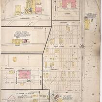
Title
-
Sanborn Map, Kansas City, Vol. 5, 1909-1938, Page p701
-
Description
-
A portion of Kansas City from E. 13th Street south to E. 15th Street and from Eastern Avenue east to Manchester Avenue, showing buildings, streets, railroads, and additions. Large numbers at edges of page refer to page with adjoining area.
-
Date
-
1909/1938
-
Object Type
-
Map
-

-
Title
-
Sanborn Map, Kansas City, Vol. 5, 1909-1938, Page p609
-
Description
-
A portion of Kansas City from E. Front Street south to Heim Avenue and from N. Brooklyn Avenue east to N. Olive, showing buildings, streets, railroads, and additions. Large numbers at edges of page refer to page with adjoining area.
-
Date
-
1909/1938
-
Object Type
-
Map
-

-
Title
-
Sanborn Map, Kansas City, Vol. 5, 1909-1938, Page p602
-
Description
-
A portion of Kansas City from E. Front Street south to E. 1st Street and from Lydia Avenue east to N. Vine, showing buildings, streets, railroads, and additions. Large numbers at edges of page refer to page with adjoining area.
-
Date
-
1909/1938
-
Object Type
-
Map
-
-
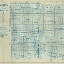
Title
-
Bates CO. Missouri
-
Description
-
Map of Bates County, Missouri, that includes paved roads, graveled roads, state or county roads not highly improved, roads, interstates and highways, railroads, drainage district line, municipal township lines, streams, and schools. Includes the townships of West Boone, East Boone, Deer Creek, Grand River, Mingo, West Point, Elkhart, Mound, Shawnee, Spruce, Homer, Charlotte, Mount Pleasant, Summit, Deepwater, Walnut, New Home, Lone Oak, Pleasant Gap, Hudson, Howard, Osage, Prairie, and Rockville.
-
Object Type
-
Map
-
-
Title
-
Sanborn Map, Kansas City, Vol. 2, 1896-1907, Page p220
-
Description
-
Several sections of northeast Kansas City between Front Street south to Nicholson Avenue and between Scott Avenue east to Monroe Avenue, showing buildings, streets, and railroad lines.
-
Date
-
1896/1907
-
Object Type
-
Map
-

-
Title
-
Sanborn Map, Kansas City, Vol. 6, 1917-1945, Page p843
-
Description
-
A portion of Sugar Creek, Missouri, from Putnam Street south to Evans Street and from Sterling Avenue east to Claremont Avenue, showing buildings, streets, and additions. Large numbers at edges of page refer to page with adjoining area.
-
Date
-
1917/1945
-
Object Type
-
Map
-
-
Title
-
Sanborn Map, Kansas City, Vol. 6, 1917-1945, Page p845
-
Description
-
A portion of Sugar Creek, Missouri from Burton Street south to Kentucky Avenue and from Sterling Avenue east to Claremont Avenue, showing buildings, streets, and additions. Large numbers at edges of page refer to page with adjoining area.
-
Date
-
1917/1945
-
Object Type
-
Map
-

-
Title
-
Sanborn Map, Kansas City, Vol. 6, 1917-1945, Page p844
-
Description
-
A portion of Sugar Creek, Missouri from Chicago Street south to Burton Street and from Sterling Avenue east to Claremont Avenue, showing buildings, streets and additions. Large numbers at edges of page refer to page with adjoining area.
-
Date
-
1917/1945
-
Object Type
-
Map
-

-
Title
-
Urban Housing With a View
-
Description
-
Article about the Morgan Group's plan to build a $48 million luxury apartment complex in the River Market area in late April. The 323-unit Market Station is the "largest downtown residential construction project since the 466-unit Quality Hill development in the mid-1980s." It will be located on a 7.4 acre tract "just east of the Broadway Bridge that once was the historic starting point of Kansas City Southern and referred to a 'milepost zero.'"
-
Date
-
2008-03-22
-
Object Type
-
Newspaper Article
-

-
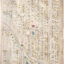
Title
-
Sanborn Map, Kansas City, Vol. 2, 1909-1937, Page p154
-
Description
-
A portion of Kansas City from Front Street south to E. 2nd Street and from Charlotte east to Harrison, showing buildings, streets, railroads, and additions. Large numbers at edges of page refer to page with adjoining area.
-
Date
-
1909/1937
-
Object Type
-
Map
-

-
Title
-
Sanborn Map, Kansas City, Vol. 2, 1909-1937, Page p160
-
Description
-
A portion of Kansas City from E. 2nd Street south to E. 5th Street and from Holmes east to Harrison, showing buildings, streets, railroads, and additions. Large numbers at edges of page refer to page with adjoining area.
-
Date
-
1909/1937
-
Object Type
-
Map
-

-
Title
-
Sanborn Map, Kansas City, Vol. 2, 1909-1937, Page p153
-
Description
-
A portion of Kansas City Old Town from E. 1st Street south to E. 2nd Street and from Cherry Street east to Charlotte, showing buildings, streets, railroads, and additions. Large numbers at edges of page refer to page with adjoining area.
-
Date
-
1909/1937
-
Object Type
-
Map
-

-
Title
-
Sanborn Map, Kansas City, Vol. 2, 1909-1937, Page p159
-
Description
-
A portion of Kansas City from E. 2nd Street south to E. 5th Street and from Oak Street east to Holmes, showing buildings, streets, railroads, and additions. Large numbers at edges of page refer to page with adjoining area.
-
Date
-
1909/1937
-
Object Type
-
Map
-

-
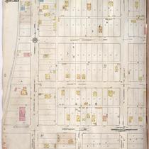
Title
-
Sanborn Map, Kansas City, Vol. 5, 1909-1938, Page p709
-
Description
-
A portion of Kansas City from E. 10th Street south to E. 12th Street and from Crystal Avenue east to Eastern Avenue, showing buildings, streets, railroads, and additions. Large numbers at edges of page refer to page with adjoining area. At the top of page, "Add'l Sheet, Aug. 1912."
-
Date
-
1909/1938
-
Object Type
-
Map
-
-
Title
-
Sanborn Map, Kansas City, Vol. 6, 1917-1957, Page p838
-
Description
-
A portion of the Intercity District connecting Kansas City, Missouri, and Independence, Missouri, from Morrell Avenue south to Independence Avenue and from Overton Avenue east to Hardy Avenue, showing buildings, streets, and additions. Large numbers at edges of page refer to page with adjoining area.
-
Date
-
1917/1957
-
Object Type
-
Map
-

-
Title
-
Sanborn Map, Kansas City, Vol. 6, 1917-1957, Page p837
-
Description
-
A portion of the Intercity District connecting Kansas City, Missouri, and Independence, Missouri, from Morrell Avenue south to Independence Avenue and from Brookside Drive east to Overton Avenue, showing buildings, streets, and additions. Large numbers at edges of page refer to page with adjoining area.
-
Date
-
1917/1957
-
Object Type
-
Map
Pages
