Pages
-

-
Title
-
Bibliography: Jayhawker to General
-
Description
-
This Jim Lane Bibliography consists of a ring-bound, fifty page listing of sources relating to former United States Senator and early Jayhawker leader, James Henry (Jim) Lane. Sources are arranged by type (Books, Periodicals, Unpublished Material, Newspapers and Ephemera, Cartographic Sources, City Directories, Government Documents, Material Artifacts, Photographic Resources, Manuscript Collection, Scrapbooks, and Addresses) then alphabetically by author(s). Most entries include a short annotation that includes information of interest and/or quotes useful to the bibliography�??s author.
-
Object Type
-
Manuscript
-

-
Title
-
Mineral Hall
-
Description
-
Photograph of the home known as Mineral Hall, circa 1982. The building was designed in 1903 by Louis Curtiss, and was the residence of Roland Bruner, whose mining wealth inspired the Mineral Hall name. A small 1905 addition to the home was designed to house Bruner's collection of mineral specimens. It was donated to the Kansas City Art Institute in 1968, and at the time of the photo, housed various administrative offices for the school and studio space for faculty. The home was added to the National Register of Historic Places in 1976.
-
Date
-
1982~
-
Object Type
-
Photograph
-

-
Title
-
Map Showing Metallic Mineral Deposits of Missouri
-
Description
-
Map of the state of Missouri depicts productive or potentially productive deposits of lead, zinc, iron, pyrites, and manganese with estimated production value per site. Insets also illustrate metal production in millions of dollars from the 1890s through 1945; value of metal production by county; and percent of total domestic production in various metals from Missouri.
-
Date
-
1948
-
Object Type
-
Map
-

-
Title
-
Mineral Resources of Nebraska-Iowa-Kansas-Missouri-Oklahoma-Arkansas
-
Description
-
Color map shows mineral deposits, production areas of coal, natural gas and petroleum, and locations of quarries, refineries, and other processing facilities. Colors and symbols designate different resources. Counties and states are labelled but not towns.
-
Date
-
1946
-
Object Type
-
Map
-

-
Title
-
Missouri Mineral Production
-
Description
-
General article about the mining and refining in Missouri of its most valuable ores.
-
Date
-
1878-05
-
Object Type
-
Magazine Article
-

-
Title
-
The Mineral Resources of Missouri
-
Description
-
Article expounding upon the wealth and variety of Missouri's mineral resources, "material progress," transportation, climate, and so on, naming its major minerals and highlighting the importance of coal, lead, and iron.
-
Date
-
1877-05
-
Object Type
-
Magazine Article
-
-
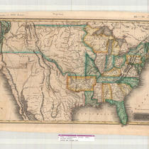
Title
-
United States
-
Description
-
Map of the United States showing Arkansas Territory, Missouri Territory (stretching to the west coast), and a large area comprising the southwest, including present-day northern Mexico. Names of many Indian tribes, and some Indian villages, appear on this map, as well as towns and rivers. The state of Missouri is shown as stretching well into present-day Iowa.
-
Date
-
1822
-
Object Type
-
Map
-

-
Title
-
Mineral Springs and Spas in Metro Area
-
Description
-
Book presents information on historic mineral springs and spas in the state of Missouri. Includes Excelsior Springs and Reed Springs under Clay County and Cusenbary Spring, Jackson Lithia Spring, Vaile Spring and Young's Medical Well under Jackson County. More springs are listed for these counties in the appendix of the book.
-
Date
-
1905-06-26
-
Object Type
-
Book
-

-
Title
-
United States Bicentennial
-
Description
-
Information about the celebration of the United States Bicentennial, including a program for an ethnic ball in Kansas City.
-
Object Type
-
Vertical File
-

-
Title
-
Johnson's United States
-
Description
-
Map of the United States, Lower California, northern Mexico, Cuba, and the Bahama Islands. State and territorial boundaries, railroad lines, rivers, and towns are indicated for the U.S., as well as forts, explorers' routes, pioneer trails, and Indian tribe locations for western U.S. Numeral 20 found in upper left corner; numeral 21 found in upper right corner.
-
Date
-
1862
-
Object Type
-
Map
-

-
Title
-
The United States Illustrated
-
Description
-
Photo of a steel engraving by J. M. Peck of Kansas City in the mid-1800s.
-
Date
-
1852
-
Object Type
-
Book
-

-
Title
-
Herb Blickhan Sells the United States on Midwestern Ingenuity
-
Description
-
Photo and history of the Blick metal manufacturing company started in 1934, called "America's most diversified shop" by the War Production Board during World War II, with some biographical information about "Herbert L. ("Herb") Blickhan, founder and operator" of the company.
-
Date
-
1950
-
Object Type
-
Book
-

-
Title
-
Missouri River Hydrographic Survey: Big Blue Bend
-
Description
-
Map of the Big Blue Bend of the Missouri River, primarily in Clay County, Missouri. Soundings across the width of the river are listed at every tenth of a mile. Topographic features such as dikes, revetments, loading docks, railroad lines are indicated, as well as major industrial sites along the river.
-
Date
-
1971
-
Object Type
-
Map
-

-
Title
-
Missouri River Hydrographic Survey: Randolph Bend
-
Description
-
Map of the Randolph Bend of the Missouri River, in Clay County and Jackson County, Missouri. Soundings across the width of the river are listed at every tenth of a mile. Topographic features such as dikes, revetments, loading docks, boat ramps, railroad lines are indicated, as well as major industrial sites along the river.
-
Date
-
1971
-
Object Type
-
Map
-

-
Title
-
Missouri River: Kansas City to Mouth
-
Description
-
Map of a stretch of the Missouri River between the Quindaro Bend and the town of Sugar Creek. Shows principal topographic features for some distance inland, indicating railroad lines, dikes, creeks (Line Creek, Rock Creek, Jersey Creek, Sugar Creek), industrial districts (with companies named), truck gardens, and timber stands. Kansas City, Kansas is shown, as well as Kansas City, Missouri, and the Missouri towns of North Kansas City, Avondale, Randolph, Minaville, and Birmingham. A stretch of the Big Blue River is included, as well.
-
Date
-
1930
-
Object Type
-
Map
-

-
Title
-
Missouri River Hydrographic Survey: Kaw Bend
-
Description
-
Map of the Kaw Bend of the Missouri River, curving around Fairfax Airport in Kansas City, Kansas. Soundings across the width of the river are listed at every tenth of a mile. Topographic features such as dikes, revetments, railroad lines are indicated, as well as major industrial sites along the river.
-
Date
-
1971
-
Object Type
-
Map
-

-
Title
-
Missouri River Hydrographic Survey: Randolph Bend-Kansas City Reach
-
Description
-
Map of the Randolph Bend-Kansas City Reach stretch of the Missouri River, from the Paseo Bridge to the Chouteau Bridge. Soundings across the width of the river are listed at every tenth of a mile. Topographic features such as dikes, revetments, loading docks, railroad lines, highways are indicated, as well as major industrial sites along the river.
-
Date
-
1971
-
Object Type
-
Map
Pages
