Pages
-

-
Title
-
Sanborn Map, Kansas City, Vol. 3, 1896-1907, Page p317
-
Description
-
Southeastern part of early Kansas City from E. 31st Street south to E. 32nd Street and from Oak Street east to Holmes Street, showing buildings, streets, and additions. Large numbers at edges of page refer to page with the adjoining area.
-
Date
-
1896/1907
-
Object Type
-
Map
-

-
Title
-
Sanborn Map, Kansas City, Vol. 3, 1896-1907, Page p271
-
Description
-
Southeastern part of early Kansas City from Matthews Avenue south to E. 23rd Street and from Agnes Avenue east to College Avenue, showing buildings, streets, and additions. Large numbers at edges of page refer to page with adjoining area.
-
Date
-
1896/1907
-
Object Type
-
Map
-
-
Title
-
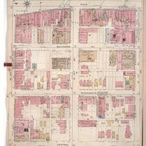
Sanborn Map, Kansas City, Vol. 1, 1895-1907, Page p008
-
Description
-
Northern part of early Kansas City from W. 9th Street south to W. 11th Street and from Central Street east to Main Street. Large numbers at edges of page refer to page showing adjoining area.
-
Date
-
1895/1907
-
Object Type
-
Map
-

-
Title
-
Sanborn Map, Kansas City, Vol. 3, 1896-1907, Page p321
-
Description
-
Southeastern part of early Kansas City from E. 33rd Street south to E. 34th Street and from Campbell Street east to Forest Avenue, showing buildings, streets, and additions. Large numbers at edges of page refer to page with the adjoining area.
-
Date
-
1896/1907
-
Object Type
-
Map
-
-
Title
-
Sanborn Map, Kansas City, Vol. 2, 1896-1907, Page p171
-
Description
-
Northeastern part of early Kansas City from E. 14th Street south to E. 16th Street and from Park Avenu east to Montgall Avenue, showing buildings, streets, and additions. Large numbers at edges of page refer to page with adjoining area.
-
Date
-
1896/1907
-
Object Type
-
Map
-

-
Title
-
Sanborn Map, Kansas City, Vol. 1, 1895-1907, Page p095
-
Description
-
Southern part of early Kansas City on the outskirts of Westport from High Street south to Archibald and from past Greenwood Place east to Belleview, showing buildings, streets, and additions. Large numbers at edges of page refer to page with adjoining area.
-
Date
-
1895/1907
-
Object Type
-
Map
-

-
Title
-
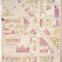
Sanborn Map, Kansas City, Vol. 1, 1895-1907, Page p072
-
Description
-
Central part of early Kansas City in the Penn Valley Park area from about W. 30th Street south to about W. 31st Street and from Summit Street east to Washington Street, showing buildings, streets, and additions.
-
Date
-
1895/1907
-
Object Type
-
Map
-

-
Title
-
Sanborn Map, Kansas City, Vol. 3, 1896-1907, Page p338
-
Description
-
Northeastern part of early Kansas City from Roberts Street south to E. 7th Street and from Porter Road east to Jackson Avenue, showing buildings, streets, and additions. Large numbers at edges of page refer to page with adjoining area.
-
Date
-
1896/1907
-
Object Type
-
Map
-

-
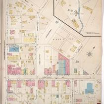
Title
-
Sanborn Map, Kansas City, Vol. 1A, 1939-1957, Page p158
-
Description
-
A portion of Kansas City from W. 30th Street south to W. 31st Street and from Madison Avenue east to Pennsylvania Avenue, showing buildings and streets. Large numbers at edges of page refer to page with adjoining area.
-
Date
-
1939/1957
-
Object Type
-
Map
-

-
Title
-
Sanborn Map, Kansas City, Vol. 2, 1896-1907, Page p214
-
Description
-
Northeastern part of early Kansas City from Rochester Avenue south to Guinotte Avenue and from Propect Avenue east to Chestnut Avenue, showing buildings, streets, and railroad lines. Large numbers at edges of page refer to page with adjoining area.
-
Date
-
1896/1907
-
Object Type
-
Map
-

-
Title
-
Sanborn Map, Kansas City, Vol. 6, 1917-1945, Page p850
-
Description
-
Portions of Kansas City, Missouri, including the Jackson County Parental Home for Negro Boys, Central Junior High, Jackson County Home for the Aged, Jackson County Home for Aged and Infirm Negroes, Interdenominational Home for Girls, and the State Highway Department Headquarters on E. 31st Street. Large numbers at edges of page refer to page with adjoining area. At top of map, "New Sheet, Dec. 1932."
-
Date
-
1932
-
Object Type
-
Map
-

-
Title
-
Sanborn Map, Kansas City, Vol. 3, 1896-1907, Page p260
-
Description
-
Southeastern part of early Kansas City from E. 20th Street south to E. 22nd Street and from Tracy Avenue east to Vine Street, showing buildings, streets, railroad lines, and O.K. Creek. Large numbers at edges of page refer to page with adjoining area.
-
Date
-
1896/1907
-
Object Type
-
Map
-
-
Title
-
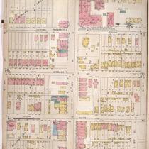
Sanborn Map, Kansas City, Vol. 1, 1895-1907, Page p051
-
Description
-
North central part of early Kansas City from W. 21st Street south to W. 24th Street and from Summit Street east to Washington Street, showing buildings, streets and additions. Large numbers at edges of page refer to page with adjoining area.
-
Date
-
1895/1907
-
Object Type
-
Map
-

-
Title
-
Sanborn Map, Kansas City, Vol. 1, 1895-1907, Page p090
-
Description
-
Southern part of early Kansas City in the Hyde Park area on the outskirts of Westport from about E. 39th Street south to E. 40th Street and from Main Street east to McGee Street, showing buildings, streets, and additions. Large numbers at edges of page refer to page with adjoining area.
-
Date
-
1895/1907
-
Object Type
-
Map
-

-
Title
-
Sanborn Map, Kansas City, Vol. 1A, 1939-1957, Page p156
-
Description
-
A portion of Kansas City from W. 30th Street south to W. 31st Street and from Wyandotte Street east to Main Street, showing buildings and streets. Large numbers at edges of page refer to page with adjoining area.
-
Date
-
1939/1957
-
Object Type
-
Map
-

-
Title
-
Sanborn Map, Kansas City, Vol. 2, 1896-1907, Page p197
-
Description
-
Northeastern part of early Kansas City from E. 10th Street south to E. 12th Street and from Bellefontaine Avenue east to Indiana Avenue, showing buildings, streets, and additions. Large numbers at edges of page refer to page with adjoining area.
-
Date
-
1896/1907
-
Object Type
-
Map
-

-
Title
-
Sanborn Map, Kansas City, Vol. 2, 1896-1907, Page p213
-
Description
-
Northeastern part of early Kansas City from Rochester Avenue south to Guinotte Avenue and from Warner Avenue east to Prospect Avenue, showing buildings, streets, and railroad lines. Large numbers at edges of page refer to page with adjoining area.
-
Date
-
1896/1907
-
Object Type
-
Map
-
-
Title
-
Sanborn Map, Kansas City, Vol. 1, 1895-1907, Page p092
-
Description
-
Southern part of early Kansas City on the outskirts of Westport from W. 40th Street south to Archibald and from Pennsylvania Avenue east to Wyandotte Street, showing buildings, streets, and additions. Large numbers at edges of page refer to page with adjoining area.
-
Date
-
1895/1907
-
Object Type
-
Map
-

-
Title
-
Sanborn Map, Kansas City, Vol. 1, 1895-1907, Page p089
-
Description
-
Southern part of early Kansas City in the Hyde Park area on the outskirts of Westport from W. 39th Street south to Westport Avenue and from Central Street east to Main Street, showing buildings, streets, and additions. Large numbers at edges of page refer to page with adjoining area.
-
Date
-
1895/1907
-
Object Type
-
Map
-

-
Title
-
Sanborn Map, Kansas City, Vol. 1, 1895-1907, Page p019
-
Description
-
Northwestern part of early Kansas City in West Bottoms from Union Avenue south to W. 13th Street and from Wyoming Street east to Mulberry Street, showing buildings, streets, and railroad lines. Large numbers on edges of page refer to page with adjoining area.
-
Date
-
1895/1907
-
Object Type
-
Map
Pages
