Pages
-

-
Title
-
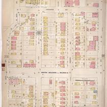
Sanborn Map, Kansas City, Vol. 3, 1896-1907, Page p317
-
Description
-
Southeastern part of early Kansas City from E. 31st Street south to E. 32nd Street and from Oak Street east to Holmes Street, showing buildings, streets, and additions. Large numbers at edges of page refer to page with the adjoining area.
-
Date
-
1896/1907
-
Object Type
-
Map
-

-
Title
-
Sanborn Map, Kansas City, Vol. 3, 1896-1907, Page p271
-
Description
-
Southeastern part of early Kansas City from Matthews Avenue south to E. 23rd Street and from Agnes Avenue east to College Avenue, showing buildings, streets, and additions. Large numbers at edges of page refer to page with adjoining area.
-
Date
-
1896/1907
-
Object Type
-
Map
-

-
Title
-
Sanborn Map, Kansas City, Vol. 3, 1896-1907, Page p321
-
Description
-
Southeastern part of early Kansas City from E. 33rd Street south to E. 34th Street and from Campbell Street east to Forest Avenue, showing buildings, streets, and additions. Large numbers at edges of page refer to page with the adjoining area.
-
Date
-
1896/1907
-
Object Type
-
Map
-

-
Title
-
Sanborn Map, Kansas City, Vol. 2, 1896-1907, Page p171
-
Description
-
Northeastern part of early Kansas City from E. 14th Street south to E. 16th Street and from Park Avenu east to Montgall Avenue, showing buildings, streets, and additions. Large numbers at edges of page refer to page with adjoining area.
-
Date
-
1896/1907
-
Object Type
-
Map
-

-
Title
-
Sanborn Map, Kansas City, Vol. 3, 1896-1907, Page p338
-
Description
-
Northeastern part of early Kansas City from Roberts Street south to E. 7th Street and from Porter Road east to Jackson Avenue, showing buildings, streets, and additions. Large numbers at edges of page refer to page with adjoining area.
-
Date
-
1896/1907
-
Object Type
-
Map
-

-
Title
-
Sanborn Map, Kansas City, Vol. 2, 1896-1907, Page p214
-
Description
-
Northeastern part of early Kansas City from Rochester Avenue south to Guinotte Avenue and from Propect Avenue east to Chestnut Avenue, showing buildings, streets, and railroad lines. Large numbers at edges of page refer to page with adjoining area.
-
Date
-
1896/1907
-
Object Type
-
Map
-

-
Title
-
Sanborn Map, Kansas City, Vol. 3, 1896-1907, Page p260
-
Description
-
Southeastern part of early Kansas City from E. 20th Street south to E. 22nd Street and from Tracy Avenue east to Vine Street, showing buildings, streets, railroad lines, and O.K. Creek. Large numbers at edges of page refer to page with adjoining area.
-
Date
-
1896/1907
-
Object Type
-
Map
-
-
Title
-
Sanborn Map, Kansas City, Vol. 2, 1896-1907, Page p197
-
Description
-
Northeastern part of early Kansas City from E. 10th Street south to E. 12th Street and from Bellefontaine Avenue east to Indiana Avenue, showing buildings, streets, and additions. Large numbers at edges of page refer to page with adjoining area.
-
Date
-
1896/1907
-
Object Type
-
Map
-

-
Title
-
Sanborn Map, Kansas City, Vol. 2, 1896-1907, Page p213
-
Description
-
Northeastern part of early Kansas City from Rochester Avenue south to Guinotte Avenue and from Warner Avenue east to Prospect Avenue, showing buildings, streets, and railroad lines. Large numbers at edges of page refer to page with adjoining area.
-
Date
-
1896/1907
-
Object Type
-
Map
-

-
Title
-
Sanborn Map, Kansas City, Vol. 2, 1896-1907, Page p114
-
Description
-
Northern part of early Kansas City from Main Street east to McGee Street and from E. 8th Street south to E. 10th Street, showing buildings, streets, and additions. Large numbers at edges of page refer to page with adjoining area.
-
Date
-
1896/1907
-
Object Type
-
Map
-

-
Title
-
Sanborn Map, Kansas City, Vol. 2, 1896-1907, Page p137
-
Description
-
Northeastern part of early Kansas City from E. 14th Street south to E. 16th Street and from Holmes Street east to Harrison Street, showing buildings, streets, and additions. Large numbers at edges of page refer to page with adjoining area.
-
Date
-
1896/1907
-
Object Type
-
Map
-

-
Title
-
Sanborn Map, Kansas City, Vol. 2, 1896-1907, Page p118
-
Description
-
Northern part of early Kansas City from E. 16th Street south to E. 18th Street and from Main Street east to McGee Street, showing buildings, streets, and additions. Large numbers at edges of page refer to page with adjoining area.
-
Date
-
1896/1907
-
Object Type
-
Map
-

-
Title
-
Sanborn Map, Kansas City, Vol. 3, 1896-1907, Page p254
-
Description
-
Southeastern part of early Kansas City from E. 20th Street south to E. 22nd Street and from about McGee Street east to Holmes Street, showing buildings, streets, and additions. Large numbers at edges of page refer to page with adjoining area.
-
Date
-
1896/1907
-
Object Type
-
Map
-

-
Title
-
Sanborn Map, Kansas City, Vol. 3, 1896-1907, Page p256
-
Description
-
Southeastern part of early Kansas City from E. 20th Street south to E. 22nd Street and from Holmes Street east to Harrison Street, showing buildings, streets, and additions. Large numbers at edges of page refer to page with adjoining area.
-
Date
-
1896/1907
-
Object Type
-
Map
-

-
Title
-
Sanborn Map, Kansas City, Vol. 3, 1896-1907, Page p289
-
Description
-
Southeastern part of early Kansas City from E. 22nd Street south to E. 24th Street and from Locust Street east to Holmes Street, showing buildings, streets, and General Hospital. Large numbers at edges of page refer to page with adjoining area.
-
Date
-
1896/1907
-
Object Type
-
Map
-

-
Title
-
Sanborn Map, Kansas City, Vol. 3, 1896-1907, Page p287
-
Description
-
Southeastern part of early Kansas City from E. 22nd Street south to E. 24th Street and from Holmes Street east to Harrison Street, showing buildings, streets, and additions. Large numbers at edges of page refer to page with adjoining area.
-
Date
-
1896/1907
-
Object Type
-
Map
-
-
Title
-
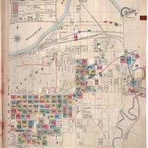
Sanborn Map, Kansas City, Vol. 3, 1896-1907, Page f004 Opt 1
-
Description
-
Key to Sanborn Map of Kansas City, Vol. 3 (corrected to June 1907), majority showing Kansas City area bounded by Main Street on the west, Cookson Avenue on the east, 18th on the North and E. 38th Street on the south. Areas northeast of that area are included as well. Also shows railroads, bridges, and the fire limits.
-
Date
-
1896/1907
-

-
Title
-
Sanborn Map, Kansas City, Vol. 3, 1896-1907, Page f004 Opt3
-
Description
-
Key to Sanborn Map of Kansas City, Vol. 3 (corrected to June 1907), majority showing Kansas City area bounded by Main Street on the west, Cookson Avenue on the east, 18th on the North and E. 38th Street on the south. Areas northeast of that area are included as well. Also shows railroads, bridges, and the fire limits.
-
Date
-
1896/1907
-

-
Title
-
Sanborn Map, Kansas City, Vol. 3, 1896-1907, Page f004 Opt2
-
Description
-
Key to Sanborn Map of Kansas City, Vol. 3 (corrected to June 1907), majority showing Kansas City area bounded by Main Street on the west, Cookson Avenue on the east, 18th on the North and E. 38th Street on the south. Areas northeast of that area are included as well. Also shows railroads, bridges, and the fire limits.
-
Date
-
1896/1907
-

-
Title
-
Sanborn Map, Kansas City, Vol. 3, 1896-1907, Page f004 Opt4
-
Description
-
Key to Sanborn Map of Kansas City, Vol. 3 (corrected to June 1907), majority showing Kansas City area bounded by Main Street on the west, Cookson Avenue on the east, 18th on the North and E. 38th Street on the south. Areas northeast of that area are included as well. Also shows railroads, bridges, and the fire limits.
-
Date
-
1896/1907
Pages
