Pages
-

-
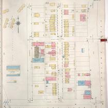
Title
-
Sanborn Map, Kansas City, Vol. 1A, 1939-1949, Page p180
-
Description
-
A portion of Kansas City from Union Avenue south to W. 12th Street and from Mulberry east to Santa Fe, showing buildings, railroads and streets. Large numbers at edges of page refer to page with adjoining area.
-
Date
-
1939/1949
-
Object Type
-
Map
-

-
Title
-
Sanborn Map, Kansas City, Vol. 1A, 1939-1949, Page p158
-
Description
-
A portion of Kansas City from W. 30th Street south to W. 31st Street and from Madison Avenue east to Pennsylvania Avenue, showing buildings and streets. Large numbers at edges of page refer to page with adjoining area.
-
Date
-
1939/1949
-
Object Type
-
Map
-
-
Title
-
Sanborn Map, Kansas City, Vol. 1A, 1939-1949, Page p156
-
Description
-
A portion of Kansas City from W. 30th Street south to W. 31st Street and from Wyandotte Street east to Main Street, showing buildings and streets. Large numbers at edges of page refer to page with adjoining area.
-
Date
-
1939/1949
-
Object Type
-
Map
-

-
Title
-
Sanborn Map, Kansas City, Vol. 1A, 1939-1949, Page p169
-
Description
-
A portion of Kansas City from W. 12th Street south to W. 17th Street and from State Line east to Genessee, showing buildings, railroads, and streets. Large numbers at edges of page refer to page with adjoining area.
-
Date
-
1939/1949
-
Object Type
-
Map
-

-
Title
-
Sanborn Map, Kansas City, Vol. 1A, 1939-1949, Page p183
-
Description
-
A portion of Kansas City from Market Street south to W. 9th Street and from the state line east to Mulberry, showing buildings, railroads and streets. Large numbers at edges of page refer to page with adjoining area.
-
Date
-
1939/1949
-
Object Type
-
Map
-

-
Title
-
Sanborn Map, Kansas City, Vol. 1A, 1939-1949, Page p168
-
Description
-
A portion of Kansas City from W. 21st Street south to W. 25th Street and from State Line east to Terrace Street, showing buildings, railroads, and streets. Large numbers at edges of page refer to page with adjoining area.
-
Date
-
1939/1949
-
Object Type
-
Map
-

-
Title
-
Sanborn Map, Kansas City, Vol. 1A, 1939-1949, Page p175
-
Description
-
A portion of Kansas City from W. 9th Street south to Saint Louis Avenue and from State Line Road east to Wyoming, showing buildings and streets. Large numbers at edges of page refer to page with adjoining area.
-
Date
-
1939/1949
-
Object Type
-
Map
-

-
Title
-
Sanborn Map, Kansas City, Vol. 1A, 1939-1949, Page p170
-
Description
-
A portion of Kansas City from W. 17th Street south to about W. 23rd Street and from State Line east to Liberty, showing buildings and streets. Large numbers at edges of page refer to page with adjoining area.
-
Date
-
1939/1949
-
Object Type
-
Map
-

-
Title
-
Sanborn Map, Kansas City, Vol. 1A, 1939-1949, Page p182
-
Description
-
A portion of Kansas City from St. Louis Avenue south to W. 12th Street and from the state line east to Liberty, showing buildings, railroads and streets. Large numbers at edges of page refer to page with adjoining area.
-
Date
-
1939/1949
-
Object Type
-
Map
-

-
Title
-
Sanborn Map, Kansas City, Vol. 1A, 1939-1949, Page p157
-
Description
-
A portion of Kansas City from W. 29th Street south to W. 30th Street and from Madison Avenue east to Pennsylvania Avenue, showing buildings and streets. Large numbers at edges of page refer to page with adjoining area.
-
Date
-
1939/1949
-
Object Type
-
Map
-

-
Title
-
Sanborn Map, Kansas City, Vol. 1A, 1939-1949, Page p129
-
Description
-
A portion of Kansas City from W. 17th Street south to W. 18th Street and from Jefferson Street east to Broadway, showing buildings and streets. Large numbers at edges of page refer to page with adjoining area.
-
Date
-
1939/1949
-
Object Type
-
Map
-

-
Title
-
Sanborn Map, Kansas City, Vol. 1A, 1939-1949, Page p112
-
Description
-
A portion of Kansas City from W. 13th Street south to W. 16th Street and from Washington Street east to Broadway, showing buildings and streets. Large numbers at edges of page refer to page with adjoining area.
-
Date
-
1939/1949
-
Object Type
-
Map
-

-
Title
-
Sanborn Map, Kansas City, Vol. 1A, 1939-1949, Page p179
-
Description
-
A portion of Kansas City from Union Avenue south to W. 12th Street and from Liberty east to Mulberry, showing buildings, railroads and streets. Large numbers at edges of page refer to page with adjoining area.
-
Date
-
1939/1949
-
Object Type
-
Map
-

-
Title
-
Sanborn Map, Kansas City, Vol. 1A, 1939-1949, Page p151
-
Description
-
A portion of Kansas City from W. 25th Street south to W. 27th Street and from Wyoming east to Jarboe, showing the Kansas City Terminal Railway Company yards, roundhouse and shops. Large numbers at edges of page refer to page with adjoining area.
-
Date
-
1939/1949
-
Object Type
-
Map
-

-
Title
-
Sanborn Map, Kansas City, Vol. 1A, 1939-1949, Page p119
-
Description
-
A portion of Kansas City from W. 16th Street south to W. 18th Street and from Broadway east to Wyandotte, showing buildings and streets. Large numbers at edges of page refer to page with adjoining area.
-
Date
-
1939/1949
-
Object Type
-
Map
-

-
Title
-
Sanborn Map, Kansas City, Vol. 1A, 1939-1949, Page p137
-
Description
-
A portion of Kansas City from W. 20th Street south to Southwest Boulevard and from W. Pennway east to Broadway, showing buildings and streets. Large numbers at edges of page refer to page with adjoining area.
-
Date
-
1939/1949
-
Object Type
-
Map
-

-
Title
-
Sanborn Map, Kansas City, Vol. 1A, 1939-1949, Page p108
-
Description
-
A portion of Kansas City from W. 11th Street south to W. 13th Street and from Pennsylvania Avenue east to Broadway, showing buildings and streets. Large numbers at edges of page refer to page with adjoining area.
-
Date
-
1939/1949
-
Object Type
-
Map
-

-
Title
-
Sanborn Map, Kansas City, Vol. 1A, 1939-1949, Page p130
-
Description
-
A portion of Kansas City from W. 18th Street south to W. 20th Street and from Jefferson Street east to Broadway, showing buildings and streets. Large numbers at edges of page refer to page with adjoining area.
-
Date
-
1939/1949
-
Object Type
-
Map
Pages


