Pages
-

-
Title
-
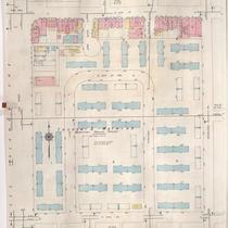
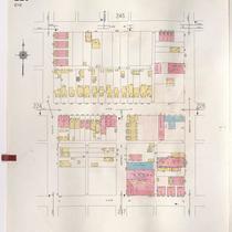
Sanborn Map, Kansas City, Vol. 2, 1940-1957, Page p250
-
Description
-
A portion of northeast Kansas City from Independence Boulevard south to E. 8th Street and from Gladstone Avenue east to Benton Boulevard, showing buildings and streets. Large numbers at edges of pages refer to page with adjoining area.
-
Date
-
1940/1957
-
Object Type
-
Map
-

-
Title
-
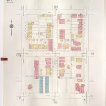
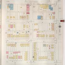
Sanborn Map, Kansas City, Vol. 2, 1940-1957, Page p276
-
Description
-
A portion of northeast Kansas City from Pendleton Avenue south to Independence Boulevard and from Woodland Avenue east to Park Avenue, showing buildings, parks and streets. Large numbers at edges of pages refer to page with adjoining area.
-
Date
-
1940/1957
-
Object Type
-
Map
-
-
Title
-
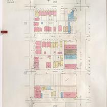
Sanborn Map, Kansas City, Vol. 2, 1940-1957, Page p211
-
Description
-
A portion of northeast Kansas City from E. 12th Street south to E. 14th Street and from The Paseo east to Woodland Avenue, showing buildings and streets. Large numbers at edges of page refer to page with adjoining area.
-
Date
-
1940/1957
-
Object Type
-
Map
-
-
Title
-
Sanborn Map, Kansas City, Vol. 2, 1940-1957, Page p217
-
Description
-
A portion of northeast Kansas City from E. 10th Street south to E. 12th Street and from Euclid Avenue east to Brooklyn Avenue, showing buildings and streets. Large numbers at edges of page refer to page with adjoining area.
-
Date
-
1940/1957
-
Object Type
-
Map
-

-
Title
-
Sanborn Map, Kansas City, Vol. 2, 1940-1957, Page p216
-
Description
-
A portion of northeast Kansas City from E. 10th Street south to E. 12th Street and from Woodland Avenue east to Euclid Avenue, showing buildings and streets. Large numbers at edges of page refer to page with adjoining area.
-
Date
-
1940/1957
-
Object Type
-
Map
-

-
Title
-
Sanborn Map, Kansas City, Vol. 2, 1940-1957, Page p213
-
Description
-
A portion of northeast Kansas City from E. 12th Street south to E. 14th Street and from Euclid Avenue east to Brooklyn Avenue, showing buildings and streets. Large numbers at edges of page refer to page with adjoining area.
-
Date
-
1940/1957
-
Object Type
-
Map
-
-
Title
-
Sanborn Map, Kansas City, Vol. 2, 1940-1957, Page p201
-
Description
-
A portion of northeast Kansas City from E. 14th Street south to E. 15th Street (Truman Road) and from Woodland Avenue east to Garfield Avenue, showing buildings, streets, and parking areas. Large numbers at edges of page refer to pages with adjoining area.
-
Date
-
1940/1957
-
Object Type
-
Map
-
-
Title
-
Sanborn Map, Kansas City, Vol. 2, 1940-1957, Page p225
-
Description
-
A portion of northeast Kansas City from E. 8th Street south to E. 10th Street and from Euclid Avenue east to Brooklyn Avenue, showing buildings and streets. Large numbers at edges of pages refer to page with adjoining area.
-
Date
-
1940/1957
-
Object Type
-
Map
-

-
Title
-
Sanborn Map, Kansas City, Vol. 2, 1940-1957, Page p224
-
Description
-
A portion of northeast Kansas City from E. 8th Street south to E. 10th Street and from Woodland Avenue east to Euclid Avenue, showing buildings and streets. Large numbers at edges of pages refer to page with adjoining area.
-
Date
-
1940/1957
-
Object Type
-
Map
-

-
Title
-
Sanborn Map, Kansas City, Vol. 2, 1940-1957, Page p212
-
Description
-
A portion of northeast Kansas City from E. 12th Street south to E. 14th Street and from Woodland Avenue east to Euclid Avenue, showing buildings and streets. Large numbers at edges of page refer to page with adjoining area.
-
Date
-
1940/1957
-
Object Type
-
Map
-

-
Title
-
Sanborn Map, Kansas City, Vol. 2, 1940-1957, Page p203
-
Description
-
A portion of northeast Kansas City from E. 14th Street south to Truman Road and from Garfield Avenue east to Olive Street, showing buildings and streets. Large numbers at edge of page refer to pages with adjoining area.
-
Date
-
1940/1957
-
Object Type
-
Map
-

-
Title
-
Sanborn Map, Kansas City, Vol. 2, 1940-1957, Page p219
-
Description
-
A portion of northeast Kansas City from E. 11th Street south to E. 13th Street and from Olive Street east to Prospect Avenue, showing buildings and streets. Large numbers at edges of page refer to page with adjoining area.
-
Date
-
1940/1957
-
Object Type
-
Map
-

-
Title
-
Sanborn Map, Kansas City, Vol. 2, 1940-1957, Page p242
-
Description
-
A portion of northeast Kansas City from E. 8th Street south to E. 11th Street and from Kensington Avenue east to Elmwood Avenue, showing buildings and streets. Large numbers at edges of pages refer to page with adjoining area.
-
Date
-
1940/1957
-
Object Type
-
Map
-

-
Title
-
Sanborn Map, Kansas City, Vol. 2, 1940-1957, Page p241
-
Description
-
A portion of northeast Kansas City from E. 8th Street south to Cloon Avenue and from Jackson Avenue east to Kensington Avenue, showing buildings and streets. Large numbers at edges of pages refer to page with adjoining area.
-
Date
-
1940/1957
-
Object Type
-
Map
-

-
Title
-
Sanborn Map, Kansas City, Vol. 2, 1940-1957, Page p208
-
Description
-
A portion of northeast Kansas City from E. 13th Street south to Truman Road and from Benton Boulevard east to Indiana Avenue, showing buildings and streets. Large numbers at edges of page refer to page with adjoining area.
-
Date
-
1940/1957
-
Object Type
-
Map
-

-
Title
-
Sanborn Map, Kansas City, Vol. 2, 1940-1957, Page p269
-
Description
-
A portion of northeast Kansas City from Windsor Avenue south to Anderson Avenue and from Monroe Avenue east to Myrtle Avenue, showing buildings and streets. Large numbers at edges of pages refer to page with adjoining area.
-
Date
-
1940/1957
-
Object Type
-
Map
-
-
Title
-
Sanborn Map, Kansas City, Vol. 2, 1940-1957, Page p252
-
Description
-
A portion of northeast Kansas City from Independence Avenue south to E. 8th Street and from Bales Court east to Cleveland Avenue, showing buildings and streets. Large numbers at edges of pages refer to page with adjoining area.
-
Date
-
1940/1957
-
Object Type
-
Map
Pages