Pages
-

-
Title
-
Sketch Map of the United States Showing the Proposed Old Trails Road
-
Description
-
Map showing the proposed Old Trails Road that was printed in 1911. The map was drwain by architect John Van Brunt, whose wife is listed as the vice chairman of the Daughters of the American Revolution in the publication containing the map. The map is credited to the Good Roads Committee of the Missouri Daughters of the American Revolution.
-
Date
-
1911
-
Object Type
-
Map
-

-
Title
-
Kansas City Municipal Farm
-
Description
-
Map and legal description of the Kansas City Municipal Farm. Map includes boundaries, details of the Kansas City Southern Railway right-of-way, and text of legal descriptions of three tracts of the farm property.
-
Date
-
1967-03-22
-
Object Type
-
Map
-

-
Title
-
Map of Grounds, Kansas City Municipal Farm
-
Description
-
Detailed map of the grounds of the Kansas City Municipal Farm. The map includes diagrams of buildings, streams, roads, Interstate 435, and the Kansas City Southern Railway. The deed citations for each tract of land comprising the grounds of the farm, as well as the year acquired, are included as map details.
-
Date
-
1964
-
Object Type
-
Map
-

-
Title
-
Bird's Eye View of Kansas City, Missouri
-
Description
-
Sepia-toned aerial view from the northeast, showing the Missouri River, Hannibal Bridge, and the city of Kansas City with streets and buildings marked. Points of interest (churches, etc.) numbered; key on back of map. Also on the back is handwritten, "Star, Sept. 30, 1928."
-
Date
-
1869
-
Object Type
-
Map
-
-
Title
-
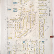
Sanborn Map, Kansas City, Vol. 9, 1930-1957, Page p1026
-
Description
-
A portion of Kansas City from W. 76th Street Terrace south to W. 80th Street and from State Line Road east to Jarboe Street, showing buildings, streets, and additions. Large numbers at edges of page refer to page with adjoining area.
-
Date
-
1930/1957
-
Object Type
-
Map
-

-
Title
-
Sanborn Map, Kansas City, Vol. 9, 1930-1957, Page p1027
-
Description
-
A portion of Kansas City from W. 80th Street south to W. 83rd Street and from State Line Road east to Belleview Avenue, showing buildings, streets, and additions. Large numbers at edges of page refer to page with adjoining area.
-
Date
-
1930/1957
-
Object Type
-
Map
-

-
Title
-
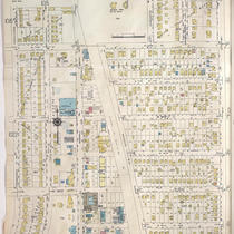
Sanborn Map, Kansas City, Vol. 9, 1930-1957, Page p1017
-
Description
-
A portion of Kansas City from E. 73rd Street south to E. 75th Street and from Baltimore Avenue east to Oak Street, showing buildings, streets, and additions. Large numbers at edges of page refer to page with adjoining area. At top of map, "Add'l Sheet, Jan. 1934."
-
Date
-
1930/1957
-
Object Type
-
Map
-
-
Title
-
Sanborn Map, Kansas City, Vol. 9, 1930-1957, Page p1023
-
Description
-
A portion of Kansas City from W. 77th Street south to W. 79th Street Terrace and from Pennsylvania Avenue east to Main Street, showing buildings, streets, and additions. Large numbers at edges of page refer to page with adjoining area. At top of map, "A. May 1941."
-
Date
-
1930/1957
-
Object Type
-
Map
-

-
Title
-
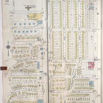
Sanborn Map, Kansas City, Vol. 9, 1930-1957, Page p1112
-
Description
-
A portion of Kansas City from E. 63rd Street south to E. 66th Street Terrace and from Troost Avenue east to Paseo Boulevard, showing buildings, streets, and additions. Large numbers at edges of page refer to page with adjoining area. At top of map, "Add'l Sheet, May 1937."
-
Date
-
1930/1957
-
Object Type
-
Map
-

-
Title
-
Sanborn Map, Kansas City, Vol. 9, 1930-1957, Page p1105
-
Description
-
A portion of Kansas City from E. 69th Street south to E. 70th Street Terrace and from Woodland Avenue east to Paseo Boulevard, showing buildings, streets, and additions. Large numbers at edges of page refer to page with adjoining area.
-
Date
-
1930/1957
-
Object Type
-
Map
-
-
Title
-
Sanborn Map, Kansas City, Vol. 9, 1930-1957, Page p0929
-
Description
-
A portion of Kansas City from E. 58th Street south to E. 59th Street and from Lydia Avenue east to Highland Avenue, showing buildings, streets, and additions. Large numbers at edges of page refer to page with adjoining area.
-
Date
-
1930/1957
-
Object Type
-
Map
-

-
Title
-
Sanborn Map, Kansas City, Vol. 9, 1930-1957, Page p1101
-
Description
-
A portion of Kansas City from E. 67th Street south to E. 68th Street Terrace and from Woodland Avenue east to Paseo Boulevard, showing buildings, streets, and additions. Large numbers at edges of page refer to page with adjoining area.
-
Date
-
1930/1957
-
Object Type
-
Map
-

-
Title
-
Sanborn Map, Kansas City, Vol. 9, 1930-1957, Page p1106
-
Description
-
A portion of Kansas City from E. 69th Street south to E. 70th Street Terrace and from Paseo Boulevard east to Olive Street, showing buildings, streets, and additions. Large numbers at edges of page refer to page with adjoining area.
-
Date
-
1930/1957
-
Object Type
-
Map
-
-
Title
-
Sanborn Map, Kansas City, Vol. 9, 1930-1957, Page p1025
-
Description
-
A portion of Kansas City from Charlotte Street east to Troost Avenue and E. 70th Street south to E. 76th Street Terrace, showing buildings, streets, and additions. Large numbers at edges of page refer to page with adjoining area.
-
Date
-
1930/1957
-
Object Type
-
Map
-

-
Title
-
Sanborn Map, Kansas City, Vol. 9, 1930-1957, Page p1018
-
Description
-
A portion of Kansas City from E. 69th Street Terrace south to E. 73rd Street and from Oak Street east to Campbell Street, showing buildings, streets, and additions. Large numbers at edges of page refer to page with adjoining area. At top of map, "Add'l Sheet, Jan. 1935."
-
Date
-
1930/1957
-
Object Type
-
Map
-

-
Title
-
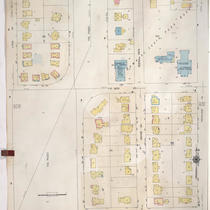
Sanborn Map, Kansas City, Vol. 9, 1930-1957, Page p1010
-
Description
-
A portion of Kansas City from E. 73rd Street south to E. 74th Street and from Main Street east to Grand Avenue, showing buildings, streets, and additions. Large numbers at edges of page refer to page with adjoining area.
-
Date
-
1930/1957
-
Object Type
-
Map
-

-
Title
-
Sanborn Map, Kansas City, Vol. 9, 1930-1957, Page p1008
-
Description
-
A portion of Kansas City from W. 70th Street south to W. 73rd Street and from Jefferson Street east to Baltimore Avenue, showing buildings, streets, and additions. Large numbers at edges of page refer to page with adjoining area. Country Club Lumber Company is noted on the map, but the 1939 city directory calls it the Snyder-Kunkel Lumber Company, 321 W. Gregory Blvd.
-
Date
-
1930/1957
-
Object Type
-
Map
-

-
Title
-
Sanborn Map, Kansas City, Vol. 9, 1930-1957, Page p1014
-
Description
-
A portion of Kansas City from W. 73rd Street south to W. 74th Street Terrace and from Broadway east to Wyandotte Street, showing buildings, streets, and additions. Large numbers at edges of page refer to page with adjoining area.
-
Date
-
1930/1957
-
Object Type
-
Map
-

-
Title
-
Sanborn Map, Kansas City, Vol. 9, 1930-1957, Page p1016
-
Description
-
A portion of Kansas City from W. 74th Street Terrace south to about W. 76th Street and from Wornall Road east to Baltimore Avenue, showing buildings, streets, and additions. Large numbers at edges of page refer to page with adjoining area.
-
Date
-
1930/1957
-
Object Type
-
Map
Pages

