Pages
-
-
Title
-
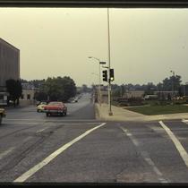
49th and Main Intersection
-
Description
-
Photograph of the intersection of 49th and Main Streets, looking south on Main, circa 1987. An office building at 4901 Main is pictured at left, and the 4900 Main Building, with United Missouri Bank as a tenant, is pictured at right.
-
Date
-
1987~
-
Object Type
-
Photograph
-

-
Title
-
Board of Trade Building
-
Description
-
Photograph of the Board of Trade building, looking northwest from the intersection of 49th and Main Streets, circa 1987. The Kansas City Board of trade moved to this building in 1966. The 4900 Main building, which includes United Missouri Bank as a tenant and also served as a Board of Trade annex, is pictured at the left edge of the image.
-
Date
-
1987~
-
Object Type
-
Photograph
-

-
Title
-
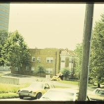
South Plaza Buildings
-
Description
-
Photograph of buildings in the South Plaza neighborhood, looking southwest from a parking lot in the 4900 block of Main Street circa 1987. The 4900 Main Building, which includes United Missouri Bank as a tenant, is pictured at the right edge of the image. A parking garage stands to the west, and the Sulgrave Apartments building is pictured to the north.
-
Date
-
1987~
-
Object Type
-
Photograph
-

-
Title
-
433 Westport Road
-
Description
-
Photograph of a the building at 433-35 Westport Road in the late 1970s. Ground floor tenants include Baber's Classic Cup at 433 Westport and Natural Wear, a clothing store, and Earth Shoe outlet, at 435 Westport. The Westport Square development united the buildings on the block bound by Westport Road, Archibald Street, Broadway, and Pennsylvania Avenue into a shopping and dining center with a central courtyard in 1973.
-
Date
-
1970~/1979~
-
Object Type
-
Photograph
-

-
Title
-
433 Westport Road
-
Description
-
Photograph of a the building at 433-35 Westport Road in the late 1970s. Ground floor tenants include Baber's Classic Cup at 433 Westport, and an architecture firm's offices occupy the second floor. The Westport Square development united the buildings on the block bound by Westport Road, Archibald Street, Broadway, and Pennsylvania Avenue into a shopping and dining center with a central courtyard in 1973.
-
Date
-
1970~/1979~
-
Object Type
-
Photograph
-

-
Title
-
Standard Oil Company Regional Headquarters Building
-
Description
-
View facing northeast of the Standard Oil Company Regional Headquarters Building located on the northwest corner of Armour and Warwick boulevards. The building would later become the home of the Foreign Language Academy school. A portion of another office building immediately to the west can be seen. The Bellerive Apartment Hotel can be seen on the right hand side of the image. Cars, work trucks and a worker on Armour Boulevard are in view.
-
Date
-
1980~
-
Object Type
-
Photograph
-
-
Title
-
Unidentified West Plaza Apartment Building
-
Description
-
Photograph of an unidentified apartment building circa 1986. The Plaza West office building, at 4600 Madison Avenue, can be seen in in the upper left edge of the image.
-
Date
-
1986~
-
Object Type
-
Photograph
-

-
Title
-
47th and Belleview Intersection
-
Description
-
Photograph from just south of the intersection of 47th and Belleview, looking north, circa 1988. The Plaza West office is visible in the background, at 4600 Madison Avenue. The Belletower office building at foreground left is located at 4700 Belleview, and the building at right is located at 919 West 47th Street.
-
Date
-
1988~
-
Object Type
-
Photograph
-

-
Title
-
47th Street West
-
Description
-
Photograph looking west on 47th Street from Belleview Avenue circa 1987. The Belletower office building, at 4700 Belleview, is pictured at the top of the hill.
-
Date
-
1987~
-
Object Type
-
Photograph
-

-
Title
-
Unidentified West Plaza House
-
Description
-
Photograph of a house and other buildings in the West Plaza area circa 1986. The Plaza West office building, at 4600 Madison Avenue, can be seen in the background.
-
Date
-
1986~
-
Object Type
-
Photograph
-
-
Title
-
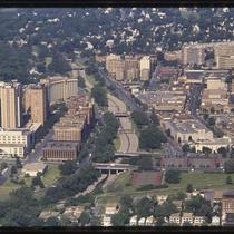
Plaza Aerial View
-
Description
-
Aerial photograph looking west through the Plaza in the 1980s, with 47th Street running along the right edge of the image and Brush Creek running through the middle. The image spans from roughly McGee Street west to State Line Road. Plaza-area commercial and residential buildings filling the bulk of the image.
-
Date
-
1980~/1989~
-
Object Type
-
Photograph, Cityscapes
-

-
Title
-
Boley Building
-
Description
-
Photograph, circa 1980s, of the Boley Building at 1130 Walnut St. It is named the Boley Building for the Boley Clothing Company that was its first occupant. Later, a Katz Drug Store and Three Sisters Clothing Store were housed there. The six-story building was designed by Kansas City architect Louis Curtiss in 1909 and is one of the first buildings in the world to utilize a glass curtain wall system. The building was listed on the National Register of Historic Places in 1971.
-
Date
-
1980~/1989~
-
Object Type
-
Photograph
-

-
Title
-
Ace Caster and Equipment, Inc.
-
Description
-
Photograph of a building at 3240 Main circa 1981. The building was designed by Kansas City architect Louis Curtiss in 1906, and at the time of the photo housed Ace Caster & Equipment, Inc. Part of the ABC Storage & Van Company building can be seen at the left of the photo, at 3244 Main.
-
Date
-
1981~
-
Object Type
-
Photograph
-

-
Title
-
Plaza Center Building
-
Description
-
Photograph of the Plaza Center (formerly John Hancock) office building on 47th Street between Madison and Summit circa 1980. The building opened in 1961 and was designed by architecture firm Skidmore, Owings and Merrill. John Hancock Life Insurance Company was an original tenant.
-
Date
-
1980~
-
Object Type
-
Photograph
-
-
Title
-
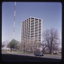
BMA Building
-
Description
-
Photograph of the BMA Tower at 700 West 31st Street circa 1980. The tower was built in 1963 to replace the former headquarters of Business Men's Assurance Company on Pershing Road, and was designed by architecture firm Skidmore Owings and Merrill. The WDAF radio tower can be seen in the background of the image.
-
Date
-
1980~
-
Object Type
-
Photograph
-

-
Title
-
City Center Square
-
Description
-
Aerial photograph of the City Center Square building at 1100 Main Street in downtown Kansas City. It was built in 1977 by the firm Skidmore, Owings & Merrill. It occupies the entire block of 11th Street to 12th Street, and from Main Street to Baltimore Street.
-
Date
-
1980~
-
Object Type
-
Photograph
-

-
Title
-
Board of Trade Building
-
Description
-
Photograph of the Board of Trade building, looking northwest from the intersection of 49th and Main Streets, circa 1980. The Kansas City Board of trade moved to this building in 1966. The Sulgrave Apartments tower, at 121 West 48th Street, can be seen at the left edge of the image.
-
Date
-
1980~
-
Object Type
-
Photograph
-

-
Title
-
South Plaza Buildings
-
Description
-
Photograph, looking south along Baltimore Avenue, of South Plaza apartment and office buildings in the late 1980s. The Casa Loma East and West and Biarritz apartment buildings can be seen to the south of Ward Parkway, with the Sulgrave apartment building to their south. East of Baltimore, the One Ward Parkway, Board of Trade, and 4900 Main office buildings are pictured, from north to south.
-
Date
-
1980~/1989~
-
Object Type
-
Photograph
-
-
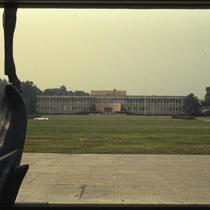
Title
-
Midwest Research Institute
-
Description
-
Photograph of the Midwest Reseach Institute at 425 Volker Boulevard circa 1987. A portion of the William Volker Memorial Fountain in Theis Park is visible at the left edge of the image.
-
Date
-
1987~
-
Object Type
-
Photograph
-

-
Title
-
Plaza Aerial View
-
Description
-
Aerial photograph looking west along 47th Street in the 1980s, Main Street west to Jarboe Street. The Nelson-Atkins Museum's grounds can be seen in the lower right, with Westwood, Kansas, at the top edge. Brush Creek is visible at the left of the image, with Plaza commercial and residential buildings filling the bulk of the picture.
-
Date
-
1980~/1989~
-
Object Type
-
Photograph, Cityscapes
Pages
