-
-
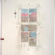
Title
-
Sanborn Map, Kansas City, Vol. 1, 1939-1958, Page p027
-
Description
-
A portion of Kansas City from W. 11th Street south to W. 13th Street and from Wyandotte east to Baltimore, showing buildings and streets. Large numbers at edges of page refer to page with adjoining area.
-
Date
-
1939/1958
-
Object Type
-
Map
-
-
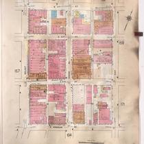
Title
-
Sanborn Map, Kansas City, Vol. 2, 1909-1937, Page p158
-
Description
-
A portion of Kansas City Old Town from E. 3rd Street south to E. Missouri Avenue and from Walnut east to Oak, showing buildings, streets, and additions. Large numbers at edges of page refer to page with adjoining area.
-
Date
-
1909/1937
-
Object Type
-
Map
-

-
Title
-
Sanborn Map, Kansas City, Vol. 1, 1895-1907, Page p046
-
Description
-
North central part of early Kansas City in the Crossroads Arts District from W. 17th Street south to W. 19th Street and from Wyandotte Street east to Main Street, showing buildings, streets and additions. Large numbers at edges of page refer to page with adjoining area.
-
Date
-
1895/1907
-
Object Type
-
Map
