Pages
-

-
Title
-
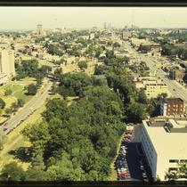
Southmoreland and Plaza Buildings
-
Description
-
Photograph, looking southeast from the top of the Fountain View (later American Century Investments north tower), across 47th Street toward the UMKC campus circa 1987. The Hilton Plaza Inn, at 1 West 45th, occupies the bottom left corner of the image, and numerous residential buildings are pictured lining 47th Street. Streetcar tracks can be seen running behind commercial buildings in the foreground, south diagonally across Main Street, before running alongside Brookside Boulevard south of Brush Creek. Main Street and Brookside Boulevard were later realigned as part of a Brush Creek beautification and flood control project in the 1990s.
-
Date
-
1987~
-
Object Type
-
Photograph
-

-
Title
-
Main Street Buildings and Southmoreland
-
Description
-
Photograph, looking east from the top of the Fountain View (later American Century Investments north tower), circa 1987. One Main Plaza office building occupies the left side of the image, and the Marriott Hotel on the right. The Southmoreland neighborhood and Kansas City Art Institute campus are visible between the buildings.
-
Date
-
1987~
-
Object Type
-
Photograph
-

-
Title
-
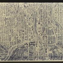
Plaza and Midtown Satellite View
-
Description
-
Satellite image of the Plaza and surrounding areas in the 1980s. The photo spans from roughly 44th Street on the north to 52nd Street on the south, and Liberty Street on the west to Harrison Street on the east. Neighborhoods including the Plaza and Southmoreland are pictured, as are parks including Mill Creek Park, Southmoreland Park, and Gillham Park.
-
Date
-
1980~/1989~
-
Object Type
-
Photograph
-

-
Title
-
218-220 Brush Creek Boulevard
-
Description
-
Photograph circa 1980s of an apartment-condominium building at 218-220 Brush Creek Boulevard (called Emanuel Cleaver II Boulevard since 1999). It was built in 1922 and is located in the Southmoreland neighborhood.
-
Date
-
1980~/1989~
-
Object Type
-
Photograph
-

-
Title
-
Plaza and Midtown Satellite View
-
Description
-
Satellite image of the Plaza and surrounding areas in the 1980s. The photo spans from roughly 42nd Street on the north to 48th Street on the south, and Genessee Street on the west to McGee Street on the east. Neighborhoods including the Plaza and Southmoreland are pictured, as are parks including Mill Creek Park and Southmoreland Park.
-
Date
-
1980~/1989~
-
Object Type
-
Photograph
-

-
Title
-
Plaza and Midtown Satellite View
-
Description
-
Satellite image of the Plaza and surrounding areas in the 1980s. The photo spans from roughly 42nd Street on the north to 49th Street on the south, and Jefferson Street on the west to Tracy Avenue on the east. Neighborhoods including the Plaza and Southmoreland are pictured, as are parks including Mill Creek Park, Southmoreland Park, and Gillham Park.
-
Date
-
1980~/1989~
-
Object Type
-
Photograph
-
-
Title
-
Plaza and Midtown Satellite View
-
Description
-
Satellite image of the Plaza and surrounding areas in the 1980s. The photo spans from roughly 39th Street on the north to 52nd Street on the south, and Rainbow Boulevard in Kansas on the west to Paseo Boulevard on the east. Neighborhoods including the Plaza and Westport are pictured, as are parks including Mill Creek Park, Southmoreland Park, and Gillham Park.
-
Date
-
1980~/1989~
-
Object Type
-
Photograph
-

-
Title
-
Nelson Art Gallery South Lawn
-
Description
-
Photograph, looking south from the south entrance of the Nelson Art Gallery, circa 1986. The view overlooks the Nelson's south lawn, across 47th Street, and across Theis Park and the Volker Memorial Fountain.
-
Date
-
1986
-
Object Type
-
Photograph
-
-
Title
-
Werby Building
-
Description
-
Photograph of the Werby Building at the southeast corner of 39th and Main Streets in 1979. The building was designed by Greenebaum, Hardy and Schumacher, opened in 1924, and consisted of office spaces on the second floor and storefronts on the ground level. Efforts to save the building from demolition led to Mayor Richard Berkley named a week in April 1979 "Werby Week," but it was razed not long after. Signs on plywood boards across the storefronts advertise a "Take Back the Night" event, an anti-nuclear energy rally to take place in Burlington, Kansas, at the Wolf Creek Generating Station, and upcoming concerts. The Hyde Park Building, on the northeast corner of 39th and Main, can be seen at the left of the photo, with the Hotel Netherlands to its north.
-
Date
-
1979
-
Object Type
-
Photograph
-
-
Title
-
Christian Science Reading Room
-
Description
-
Photograph of the Christian Science Reading Room at 3921 Main Street, circa 1982, in a building constructed in 1921. The vacant lot to its left is the site of the former Werby Building, demolished in 1979, and part of the Meyer Building can be seen to its right.
-
Date
-
1982~
-
Object Type
-
Photograph
-

-
Title
-
Southwell Building Architectural Detail
-
Description
-
Detail photograph of the Art Deco terra cotta detail on the second floor of the Southwell Building, at 3935-41 Main Street, at the intersection of Main Street and Westport Road in the late 1970s. The building was designed by architects McKecknie and Trask and opened in 1929.
-
Date
-
1970~/1979~
-
Object Type
-
Photograph
-

-
Title
-
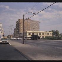
Streetcar Tracks at 47th and Main
-
Description
-
Photograph of the intersection of 47th and Main Streets, looking south along Main, circa 1980. Decommissioned streetcar tracks are pictured in the foreground of the image, running along the path of what later would be Brookside Boulevard's connection to Main Street.
-
Date
-
1980~
-
Object Type
-
Photograph
-
-
Title
-
Westport and Main
-
Description
-
Photograph of the Montrose Apartments building at the corner of 40th and Main Streets in the early 1980s, looking east from the intersection of Westport Road and Main. The building was designed by Shepard & Wiser and built in 1923. It was demolished in early 1998 and the site used for a parking lot. St. Paul's Episcopal Church stands to the south, across 40th Street.
-
Date
-
1980~/1989~
-
Object Type
-
Photograph
-

-
Title
-
210-16 Brush Creek Boulevard
-
Description
-
Photograph circa 1980s of two apartment buildings on the north side of Brush Creek Boulevard (called Emanuel Cleaver II Boulevard since 1999), east of Main Street. 210-12 Brush Creek Boulevard (on the left) is called the Granada and 214-16 Brush Creek Boulevard is named Plaza 52. They were built in 1922.
-
Date
-
1980~/1989~
-
Object Type
-
Photograph
-

-
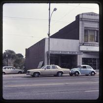
Title
-
Southwell Building
-
Description
-
Photograph of the Southwell Building at the intersection of Main Street and Westport Road, in the late 1980s. The building was designed by architects McKecknie and Trask and opened in 1929. Recycled Sounds, The Futon Company, and Metcalfe Key are among the ground-floor tenants, with Harling's Upstairs Bar and Grill occupying the second floor.
-
Date
-
1980~/1989~
-
Object Type
-
Photograph
-
-
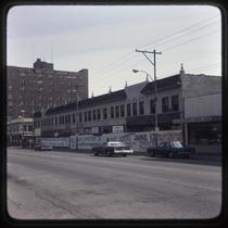
Title
-
39th and Main Streets
-
Description
-
Photograph of the intersection of 39th and Main Streets in the early 1980s. The Netherlands Hotel apartment building and commercial Hyde Park building can be seen on the northeast corner, and the New Earth Books & Records store in the former Price Candy Company building on the northwest corner. A Mobil gas station stands on the southwest corner. The photograph was taken after the demolition of the Werby Building on the southeast corner, circa 1980.
-
Date
-
1980~/1989~
-
Object Type
-
Photograph
-
-
Title
-
J. C. Nichols Parkway and Main Street through Midtown
-
Description
-
Photograph looking north from the top of the Fountain View (later American Century Investments north tower) along J. C. Nichols Parkway/Broadway Boulevard (at left) and Main Street (at right) circa 1987. The Embassy Suites hotel, at at 220 West 43rd Street, is at left, with the streetcar 43rd Street viaduct cross over the intersection of 43rd Street and J. C. Nichols Parkway. Commercial and residential buildings, including the H&R Block headquarters in the lower right corner, line both streets. The downtown skyline can be seen in the background of the image.
-
Date
-
1987~
-
Object Type
-
Photograph
-

-
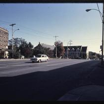
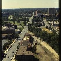
Title
-
47th and Main Intersection
-
Description
-
Photograph, looking south from the top of the Fountain View (later American Century Investments north tower), toward the intersection of 47th and Main Streets circa 1987. Streetcar tracks can be seen running behind commercial buildings in the foreground, south diagonally across Main Street, before running alongside Brookside Boulevard south of Brush Creek. The Plaza Tennis Center courts are visible in the center of the image. Main Street and Brookside Boulevard were later realigned as part of a Brush Creek beautification and flood control project in the 1990s.
-
Date
-
1980~/1989~
-
Object Type
-
Photograph
-

-
Title
-
3901-3915 Main Street
-
Description
-
Photograph of demolition of buildings in the early 1980s at 3901 - 3915 Main Street, including the Werby Building on the southeast corner at the intersection of 39th and Main Streets. The spire of the Calvary Baptist Church at 3921 Baltimore can be seen in the background.
-
Date
-
1980~/1989~
-
Object Type
-
Photograph
-
-
Title
-
47th and Main Intersection
-
Description
-
Photograph, looking south from the top of the Fountain View (later American Century Investments north tower), toward the intersection of 47th and Main Streets. Streetcar tracks can be seen running behind commercial buildings in the foreground, south diagonally across Main Street, before running alongside Brookside Boulevard south of Brush Creek. The Plaza Tennis Center courts are visible in the center of the image. Main Street and Brookside Boulevard were later realigned as part of a Brush Creek beautification and flood control project in the 1990s.
-
Date
-
1980~/1989~
-
Object Type
-
Photograph
Pages
