Pages
-
-
Title
-
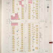
Sanborn Map, Kansas City, Vol. 5, 1940-1941, Page p0632
-
Description
-
A portion of Kansas City from Windsor Avenue south to Anderson Avenue and from Elmwood Avenue east to Van Brunt Boulevard, showing buildings and streets. Large numbers at edges of page refer to page with adjoining area. Top of sheet indicates that this page number corresponds with page 621, 622, 715 and 716 in Vol. 5, 1909-1938.
-
Date
-
1940/1941
-
Object Type
-
Map
-

-
Title
-
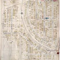
Sanborn Map, Kansas City, Vol. 2, 1940-1950, Page p248
-
Description
-
A portion of northeast Kansas City from Independence Boulevard south to E. 8th Street and from Prospect Avenue east to Chestnut Avenue, showing buildings and streets. Large numbers at edges of pages refer to page with adjoining area.
-
Date
-
1940/1950
-
Object Type
-
Map
-

-
Title
-
Sanborn Map, Kansas City, Vol. 3, 1909-1957, Page p319
-
Description
-
A portion of Kansas City from E. 17th Street Terrace south to E. 19th Street and from The Paseo east to Woodland Avenue, showing buildings, streets, and additions. Large numbers at edges of page refer to page with adjoining area.
-
Date
-
1909/1957
-
Object Type
-
Map
-

-
Title
-
Sanborn Map, Kansas City, Vol. 4, 1909-1950, Page p510
-
Description
-
A portion of Kansas City from E. 38th Street south to E. 39th Street and from Highland Avenue east to Garfield Avenue, showing buildings, streets, and additions. Large numbers at edges of page refer to page with adjoining area.
-
Date
-
1909/1950
-
Object Type
-
Map
-

-
Title
-
Sanborn Map, Kansas City, Vol. 4, 1909-1950, Page p533
-
Description
-
A portion of Kansas City from E. 39th Street south to E. 40th Street and from Campbell Street east to Forest Avenue, showing buildings, streets and additions. Large numbers at edges of page refer to page with adjoining area.
-
Date
-
1909/1950
-
Object Type
-
Map
-

-
Title
-
Sanborn Map, Kansas City, Vol. 3, 1909-1950, Page p318
-
Description
-
A portion of Kansas City from E. 17th Street south to E. 19th Street and from Tracy Avenue east to The Paseo, showing buildings, streets, and additions. Large numbers at edges of page refer to page with adjoining area. Handwritten at the top of the page, "Negro Section."
-
Date
-
1909/1950
-
Object Type
-
Map
-

-
Title
-
Sanborn Map, Kansas City, Vol. 3, 1909-1957, Page p386
-
Description
-
A portion of Kansas City from E. 26th Street south to E. 27th Street and from Prospect Avenue east to Agnes Avenue, showing buildings, streets, and additions. Large numbers at edges of page refer to page with adjoining area.
-
Date
-
1909/1957
-
Object Type
-
Map
-

-
Title
-
Sanborn Map, Kansas City, Vol. 2, 1940-1950, Page p232
-
Description
-
A portion of northeast Kansas City from E. 11th Street south to E. 13th Street and from Benton Boulevard east to Indiana Avenue, showing buildings and streets. Large numbers at edges of pages refer to page with adjoining area.
-
Date
-
1940/1950
-
Object Type
-
Map
-

-
Title
-
Sanborn Map, Kansas City, Vol. 2, 1940-1950, Page p215
-
Description
-
A portion of northeast Kansas City from E. 10th Street south to E. 12th Street and from The Paseo east to Woodland Avenue, showing buildings and streets. Large numbers at edges of page refer to page with adjoining area.
-
Date
-
1940/1950
-
Object Type
-
Map
-

-
Title
-
Sanborn Map, Kansas City, Vol. 2, 1940-1957, Page p232
-
Description
-
A portion of northeast Kansas City from E. 11th Street south to E. 13th Street and from Benton Boulevard east to Indiana Avenue, showing buildings and streets. Large numbers at edges of pages refer to page with adjoining area.
-
Date
-
1940/1957
-
Object Type
-
Map
-

-
Title
-
Sanborn Map, Kansas City, Vol. 5, 1940-1941, Page p0638
-
Description
-
A portion of Kansas City from St. John south to Anderson Avenue and from Hardesy Avenue east to Lawndale Avenue, showing buildings and streets. Large numbers at edges of page refer to page with adjoining area. Indicated at top of sheet that this page number corresponds with page 630 in Vol. 5, 1909-1938.
-
Date
-
1940/1941
-
Object Type
-
Map
-

-
Title
-
Sanborn Map, Kansas City, Vol. 5, 1940-1941, Page p0604
-
Description
-
A portion of Kansas City from E. 12th Street Terrace south to E. 15th Street and from Bellaire Avenue east to Belmont Avenue, showing buildings and streets. Large numbers at edges of page refer to page with adjoining area. Indicated at top of sheet that this page number corresponds with page 660 in Vol. 5, 1909-1938.
-
Date
-
1940/1941
-
Object Type
-
Map
-

-
Title
-
Sanborn Map, Kansas City, Vol. 3, 1909-1950, Page p388
-
Description
-
A portion of Kansas City from E. 26th Street Terrace south to Lockridge and from Agnes Avenue east to Indiana Avenue, showing buildings, streets and additions. Large numbers at edges of page refer to page with adjoining area.
-
Date
-
1909/1950
-
Object Type
-
Map
-

-
Title
-
Missouri Theater, Exterior
-
Description
-
Exterior view of side of Missouri Theater at 14th and Main streets, looking southwest along 14th Street. Theater opened as the Main Street Theater in 1921, changing to the Missouri Theater in 1941. It was later purchased by RKO and renamed the Empire Theater. It was renovated by AMC Entertainment and reopened in 2009 as AMC Main Street Theater, a first-run cineplex.
-
Date
-
1950~
-
Object Type
-
Negative
-

-
Title
-
12th and Main Streets
-
Description
-
Looking north along Main Street from 12th Street. On the right is the southwest corner of the Jones Store building. Harzfeld's Department Store is visible one block south, and signs for King Joy Lo Restaurant, Liggett's Drugs, B & G Hosiery, Newman Theater, and Berkson's line the west side of the street from south to north. The block on the west side of Main was razed in the early 1970s and now occupied by City Center Square.
-
Date
-
1940~
-
Object Type
-
Negative
-

-
Title
-
Sanborn Map, Kansas City, Vol. 6, 1917-1945, Page p854
-
Description
-
A portion of the Intercity District between Kansas City, Missouri, and Independence, Missouri, from E. 11th Street south to E. 14th Street and from Glenwood Avenue east to Ralston Avenue, showing buildings, streets, and additions. Large numbers at edges of page refer to page with adjoining area. At top of map, "Add'l Sheet, Nov. 1936."
-
Date
-
1936
-
Object Type
-
Map
-

-
Title
-
Sanborn Map, Kansas City, Vol. 6, 1917-1945, Page p760
-
Description
-
A portion of northeastern Kansas City from E. 35th Street south to E. 36th Street and from Bellefontaine Avenue east to Indiana Avenue, showing buildings, streets, and additions. Large numbers at edges of page refer to page with adjoining area.
-
Date
-
1917/1945
-
Object Type
-
Map
-
-
Title
-
Sanborn Map, Kansas City, Vol. 6, 1917-1945, Page p840
-
Description
-
A portion of the Intercity District connecting Kansas City, Missouri, and Independence, Missouri, from Independence Avenue south to E. 11th Street and from Overton Avenue east to Hardy Avenue, showing buildings, streets, and additions. Large numbers at edges of page refer to page with adjoining area.
-
Date
-
1917/1945
-
Object Type
-
Map
-

-
Title
-
Sanborn Map, Kansas City, Vol. 6, 1917-1945, Page p783
-
Description
-
A portion of northeastern Kansas City from E. 49th Street south to E. 51st Street and from Prospect Avenue east to South Benton Boulevard, showing buildings, streets, and additions. Large numbers at edges of page refer to page with adjoining area.
-
Date
-
1917/1945
-
Object Type
-
Map
-

-
Title
-
Sanborn Map, Kansas City, Vol. 6, 1917-1945, Page p831
-
Description
-
A portion of Kansas City from E. 80th Street south to E. 81st Street Terrace and from Highland Avenue east to Euclid Avenue, showing buildings, streets, and additions. Large numbers at edges of page refer to page with adjoining area.
-
Date
-
1917/1945
-
Object Type
-
Map
Pages
