Pages
-

-
Title
-
Country Club Plaza
-
Description
-
Distant winter view looking northwest from Main Street bridge over Brush Creek.
-
Date
-
1950
-
Object Type
-
Photograph
-

-
Title
-
Brush Creek Band
-
Description
-
View looking northwest of an unidentified big band playing in Brush Creek beneath a pedestrian bridge that crossed the stream at Central Street. Several concert attendees can be seen.
-
Date
-
1980~
-
Object Type
-
Photograph
-

-
Title
-
Maynard Ferguson in Brush Creek
-
Description
-
View looking northwest of Maynard Ferguson and his band playing in Brush Creek beneath a pedestrian bridge that crossed the stream at Central Street. Several concert attendees can be seen.
-
Date
-
1980~
-
Object Type
-
Photograph
-

-
Title
-
Sister Cities Sign
-
Description
-
View looking southeast of a sister cities sign that once stood along Brush Creek's northern bank in the Country Club Plaza. The following cities are listed on the sign: Seville, Spain - 4700 miles; Freetown, Sierra Leone, Africa - 5000 miles; Kurashiki, Japan - 7000 miles; Tainan, Taiwan - 7500 miles; Morelia, Mexico - 1200 miles.
-
Date
-
1980~
-
Object Type
-
Photograph
-

-
Title
-
Brush Creek Band
-
Description
-
View looking southwest of an unidentified big band playing in Brush Creek beneath a pedestrian bridge that crossed the stream at Central Street. Several concert attendees can be seen.
-
Date
-
1980~
-
Object Type
-
Photograph
-

-
Title
-
Brush Creek
-
Description
-
View of children and adults wading in Brush Creek in the Country Club Plaza.
-
Date
-
1980~
-
Object Type
-
Photograph
-

-
Title
-
Alameda Plaza Hotel
-
Description
-
View looking south along Wornall Road from its bridge over Brush Creek showing the Alameda Plaza Hotel at 401 Ward Parkway in the Country Club Plaza.
-
Date
-
1980~
-
Object Type
-
Photograph
-

-
Title
-
Country Club Plaza
-
Description
-
Elevated view looking northwest of the Country Club Plaza. Brush Creek and Ward Parkway can be seen in the foreground.
-
Date
-
1940~
-
Object Type
-
Photograph
-

-
Title
-
Country Club Plaza
-
Description
-
Aerial view of Country Club Plaza area, looking northeast near 55th Street and Ward Parkway. Parts of Loose Park are in view. Brush Creek before it was paved is also in view.
-
Date
-
1930~
-
Object Type
-
Photograph
-

-
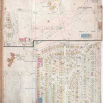
Title
-
Sanborn Map, Kansas City, Vol. 3, 1896-1907, Page p352
-
Description
-
Southeastern part of early Kansas City in the Waldo residential district, showing buildings, streets, and additions. Large numbers at edges of page refer to page with adjoining area.
-
Date
-
1896/1907
-
Object Type
-
Map
-

-
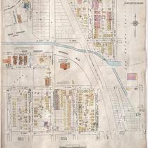
Title
-
Sanborn Map, Kansas City, Vol. 4, 1909-1957, Page p548
-
Description
-
A portion of Kansas City from E. 45th Street south to E. 47th Street and from Virginia Avenue east to Michigan Avenue, showing buildings, streets, and additions. Large numbers at edges of page refer to page with adjoining area.
-
Date
-
1909/1957
-
Object Type
-
Map
-

-
Title
-
Sanborn Map, Kansas City, Vol. 4, 1909-1957, Page p549
-
Description
-
A portion of Kansas City from E. 47th Street south to Volker Boulevard and from McGee east to Locust, showing buildings, streets, and additions. Large numbers at edges of page refer to page with adjoining area.
-
Date
-
1909/1957
-
Object Type
-
Map
-
-
Title
-
Sanborn Map, Kansas City, Vol. 6, 1917-1945, Page p852
-
Description
-
A portion of Kansas City, Missouri, from E. 49th Street south to E. 51st Street and from Grand Avenue east to Lydia Avenue, showing buildings, streets, and additions. Large numbers at edges of page refer to page with adjoining area. At top of map, "Add'l Sheet, Dec. 1933."
-
Date
-
1933
-
Object Type
-
Map
-

-
Title
-
Sanborn Map, Kansas City, Vol. 4, 1909-1957, Page p550
-
Description
-
A portion of Kansas City from E. 47th Street south to Volker Boulevard and from Rockhill Road east to Charlotte, showing buildings, streets, and additions. Large numbers at edges of page refer to page with adjoining area.
-
Date
-
1909/1957
-
Object Type
-
Map
-

-
Title
-
Sanborn Map, Kansas City, Vol. 6, 1917-1945, Page p800
-
Description
-
A portion of western Kansas City from W. 51st Street south to W. 54th Street and from State Line Road east to Belleview Avenue, showing buildings, streets, and additions. Large numbers at edges of page refer to page with adjoining area.
-
Date
-
1917/1945
-
Object Type
-
Map
-

-
Title
-
Sanborn Map, Kansas City, Vol. 6, 1917-1945, Page p799
-
Description
-
A portion of western Kansas City from W. 48th Street south to W. 51st Street and from State Line Road east to Holly Street, showing buildings, streets, and additions. Large numbers at edges of page refer to page with adjoining area.
-
Date
-
1917/1945
-
Object Type
-
Map
-

-
Title
-
Bridge over Brush Creek
-
Description
-
Postcard of a stone bridge over Brush Creek near Rockhill Road.
-
Date
-
1912~
-
Object Type
-
Postcard
-

-
Title
-
Sanborn Map, Kansas City, Vol. 6, 1917-1945, Page p797
-
Description
-
A portion of western Kansas City from W. 47th Street south to W. 50th Street and from Jefferson Avenue east to Wyandotte Avenue, showing buildings, streets, and additions. Large numbers at edges of page refer to page with adjoining area.
-
Date
-
1917/1945
-
Object Type
-
Map
-
-
Title
-
Sanborn Map, Kansas City, Vol. 6, 1917-1945, Page p798
-
Description
-
A portion of western Kansas City from W. 47th Street south to W. 50th Street and from Wyandotte Street east to Oak Street, showing buildings, streets, and additions. Large numbers at edges of page refer to page with adjoining area.
-
Date
-
1917/1945
-
Object Type
-
Map
-

-
Title
-
Brush Creek
-
Description
-
Looking southwest at east side of bridge crossing Brush Creek at Belleview and Ward Parkway.
-
Date
-
1932-06-13
-
Object Type
-
Photograph
Pages
