Pages
-

-
Title
-
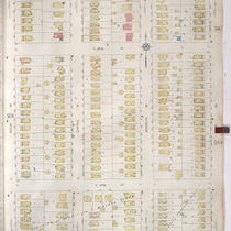
Sanborn Map, Kansas City, Vol. 9, 1930-1957, Page p0916
-
Description
-
A portion of Kansas City from E. 54th Street south to E. 55th Street and from Highland Avenue east to Euclid Avenue, showing buildings, streets, and additions. Large numbers at edges of page refer to page with adjoining area.
-
Date
-
1930/1957
-
Object Type
-
Map
-

-
Title
-
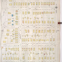
Sanborn Map, Kansas City, Vol. 9, 1930-1957, Page p0917
-
Description
-
A portion of Kansas City from E. 54th Street south to E. 55th Street and from Euclid Avenue east to Park Avenue, showing buildings, streets, and additions. Large numbers at edges of page refer to page with adjoining area.
-
Date
-
1930/1957
-
Object Type
-
Map
-
-
Title
-
Sanborn Map, Kansas City, Vol. 9, 1930-1957, Page p0918
-
Description
-
A portion of Kansas City from E. 56th Street south to E. 57th Street and from Euclid Avenue east to Park Avenue, showing buildings, streets, and additions. Large numbers at edges of page refer to page with adjoining area.
-
Date
-
1930/1957
-
Object Type
-
Map
-

-
Title
-
Sanborn Map, Kansas City, Vol. 9, 1930-1957, Page p1118
-
Description
-
A portion of Kansas City from E. Gregory Boulevard south to E. 74th Street and from Troost Avenue east to Lydia Avenue, showing buildings, streets, and additions. Large numbers at edges of page refer to page with adjoining area.
-
Date
-
1930/1957
-
Object Type
-
Map
-

-
Title
-
Sanborn Map, Kansas City, Vol. 9, 1930-1957, Page p1113
-
Description
-
A portion of Kansas City from E. 74th Street south to E. 77th Street and from Troost Avenue east to Wayne Avenue, showing buildings, streets, and additions. Large numbers at edges of page refer to page with adjoining area. At top of map, "Add'l Sheet, May 1937."
-
Date
-
1930/1957
-
Object Type
-
Map
-

-
Title
-
Sanborn Map, Kansas City, Vol. 9, 1930-1957, Page p1115
-
Description
-
A portion of Kansas City from E. 63rd Street south to Meyer Boulevard and from Prospect Avenue east to College Avenue, showing buildings, streets, and additions. Large numbers at edges of page refer to page with adjoining area.
-
Date
-
1930/1957
-
Object Type
-
Map
-

-
Title
-
Sanborn Map, Kansas City, Vol. 9, 1930-1957, Page p1114
-
Description
-
A portion of Kansas City from E. 74th Street south to E. 77th Street and from Wayne Avenue east to Brooklyn Avenue, showing buildings, streets, and additions. Large numbers at edges of page refer to page with adjoining area. At top of map, "Add'l Sheet, May 1937."
-
Date
-
1930/1957
-
Object Type
-
Map
-

-
Title
-
Sanborn Map, Kansas City, Vol. 9, 1930-1957, Page p1110
-
Description
-
A portion of Kansas City from E. Gregory Boulevard south to E. 74th Street and from Montgall Avenue east to Walrond Avenue, showing buildings, streets, and additions. Large numbers at edges of page refer to page with adjoining area. At top of map, "Add'l Sheet, Jan. 1933."
-
Date
-
1930/1957
-
Object Type
-
Map
-
-
Title
-
Sanborn Map, Kansas City, Vol. 9, 1930-1957, Page p1106
-
Description
-
A portion of Kansas City from E. 69th Street south to E. 70th Street Terrace and from Paseo Boulevard east to Olive Street, showing buildings, streets, and additions. Large numbers at edges of page refer to page with adjoining area.
-
Date
-
1930/1957
-
Object Type
-
Map
-

-
Title
-
Sanborn Map, Kansas City, Vol. 9, 1930-1957, Page p0933
-
Description
-
A portion of Kansas City from E. 59th Street south to E. 61st Street and from Oak Street east to Kenwood Avenue, showing buildings, streets, and additions. Large numbers at edges of page refer to page with adjoining area.
-
Date
-
1930/1957
-
Object Type
-
Map
-

-
Title
-
Sanborn Map, Kansas City, Vol. 9, 1930-1957, Page p0939
-
Description
-
A portion of Kansas City from E. 61st Street south to E. 63rd Street and from Rockhill Road east to Forest Avenue, showing buildings, streets, and additions. Large numbers at edges of page refer to page with adjoining area.
-
Date
-
1930/1957
-
Object Type
-
Map
-

-
Title
-
Sanborn Map, Kansas City, Vol. 9, 1930-1957, Page p1116
-
Description
-
A portion of Kansas City from E. 81st Street south to E. 83rd Street and from Troost Avenue east to Highland Avenue, showing buildings, streets, and additions. Large numbers at edges of page refer to page with adjoining area.
-
Date
-
1930/1957
-
Object Type
-
Map
-

-
Title
-
Sanborn Map, Kansas City, Vol. 9, 1930-1957, Page p1111
-
Description
-
A portion of Kansas City from E. 70th Street Terrace south to E. 74th Street and from Paseo Boulevard east to Olive Street, showing buildings, streets, and additions. Large numbers at edges of page refer to page with adjoining area. At top of map, "Add'l Sheet, Jan. 1936."
-
Date
-
1930/1957
-
Object Type
-
Map
-

-
Title
-
Bird's Eye View of Kansas City, Missouri
-
Description
-
Aerial view of Kansas City from the northeast. Buildings, railroad lines, and other features rendered pictorially. Key at bottom of map identifies churches, schools, reservoirs, businesses, etc. Street names are shown. Hannibal Bridge is shown open for river traffic.
-
Date
-
1878
-
Object Type
-
Map
-

-
Title
-
Housing Survey - Kansas City, Missouri - Negro Districts Map
-
Description
-
Map prepared by the Missouri Era Non-Manual Works Program, the City Plan Commission, and the Jackson County Emergency Relief Committee showing African American population centers in Kansas City in 1934. The map was included as part of the 1934-1935 Report of the Housing Survey of Kansas City, Missouri.
-
Date
-
1934
-
Object Type
-
Map
-

-
Title
-
Kansas City Metropolitan Area
-
Description
-
Plat map of the greater Kansas City area, including north Independence and southern Clay County.
-
Date
-
1927
-
Object Type
-
Map
-

-
Title
-
Transportation Map and Guide of Greater Kansas City
-
Description
-
Map of streetcar, trolley, and motor bus lines in Kansas City with an enlarged map of downtown area inset. Lines are identified by key on map. Also has a list of points of interest and downtown businesses as well as an index to service clubs, hotels, ticket offices, and theatres in the downtown area.
-
Date
-
1944
-
Object Type
-
Map
Pages