Pages
-

-
Title
-
Wheatley-Provident Hospital
-
Description
-
View looking northwest of the Wheatley-Provident Hospital building at 1826 Forest Avenue. Cars parked along Forest Avenue can be seen.
-
Date
-
1967-12
-
Object Type
-
Photograph
-

-
Title
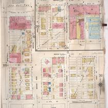
-
Sanborn Map, Kansas City, Vol. 2, 1909-1937, Page p247
-
Description
-
A portion of Kansas City from E. 13th Street south to E. 15th Street and from Lydia Avenue east to Highland Avenue, showing buildings, streets, and additions. Large numbers at edges of page refer to page with adjoining area.
-
Date
-
1909/1937
-
Object Type
-
Map
-

-
Title
-
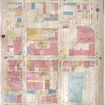
Sanborn Map, Kansas City, Vol. 2, 1909-1937, Page p251
-
Description
-
A portion of Kansas City from E. 13th Street south to E. 15th Street and from Prospect Avenue east to Kansas Avenue, showing buildings, streets, and additions. Large numbers at edges of page refer to page with adjoining area.
-
Date
-
1909/1937
-
Object Type
-
Map
-

-
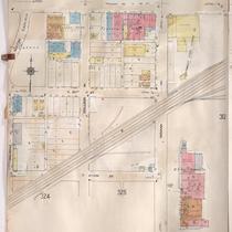
Title
-
Sanborn Map, Kansas City, Vol. 3, 1909-1950, Page p319
-
Description
-
A portion of Kansas City from E. 17th Street south to E. 19th Street and from The Paseo east to Woodland Avenue, showing buildings, streets, and additions. Large numbers at edges of page refer to page with adjoining area.
-
Date
-
1909/1950
-
Object Type
-
Map
-

-
Title
-
Sanborn Map, Kansas City, Vol. 3, 1909-1957, Page p324
-
Description
-
A portion of Kansas City from E. 17th Street south to E. 19th Street and from Agnes Avenue east to College Avenue, showing buildings, streets, and additions. Large numbers at edges of page refer to page with adjoining area.
-
Date
-
1909/1957
-
Object Type
-
Map
-

-
Title
-
Sanborn Map, Kansas City, Vol. 3, 1909-1957, Page p318
-
Description
-
A portion of Kansas City from E. 17th Street south to E. 19th Street and from Tracy Avenue east to The Paseo, showing buildings, streets, and additions. Large numbers at edges of page refer to page with adjoining area.
-
Date
-
1909/1957
-
Object Type
-
Map
-

-
Title
-
Sanborn Map, Kansas City, Vol. 3, 1909-1957, Page p322
-
Description
-
A portion of Kansas City from E. 17th Street south to E. 19th Street and from Olive east to Montgall Avenue, showing buildings, streets, and additions. Large numbers at edges of page refer to page with adjoining area. Formerly, the City Ice Company was in this section of town.
-
Date
-
1909/1957
-
Object Type
-
Map
-

-
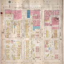
Title
-
Sanborn Map, Kansas City, Vol. 2, 1940-1950, Page p207
-
Description
-
A portion of northeast Kansas City from E. 13th Street south to Truman Road and from Agnes Avenue east to Benton Boulevard, showing buildings and streets. Large numbers at edges of page refer to page with adjoining area.
-
Date
-
1940/1950
-
Object Type
-
Map
-

-
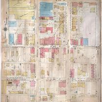
Title
-
Sanborn Map, Kansas City, Vol. 3, 1909-1957, Page p309
-
Description
-
A portion of Kansas City from Truman Road south to E. 17th Street and from Olive east to Montgall Avenue, showing buildings, streets, and additions. Large numbers at edges of page refer to page with adjoining area.
-
Date
-
1909/1957
-
Object Type
-
Map
-
-
Title
-
Sanborn Map, Kansas City, Vol. 3, 1909-1957, Page p311
-
Description
-
A portion of Kansas City from Truman Road south to E. 17th Street and from Walrond Avenue east to Indiana Avenue, showing buildings, streets, railroads and additions. Large numbers at edges of page refer to page with adjoining area.
-
Date
-
1909/1957
-
Object Type
-
Map
-

-
Title
-
Sanborn Map, Kansas City, Vol. 3, 1909-1957, Page p319
-
Description
-
A portion of Kansas City from E. 17th Street Terrace south to E. 19th Street and from The Paseo east to Woodland Avenue, showing buildings, streets, and additions. Large numbers at edges of page refer to page with adjoining area.
-
Date
-
1909/1957
-
Object Type
-
Map
-
-
Title
-
Sanborn Map, Kansas City, Vol. 3, 1909-1950, Page p309
-
Description
-
A portion of Kansas City from Truman Road south to E. 17th Street and from Olive east to Montgall Avenue, showing buildings, streets, and additions. Large numbers at edges of page refer to page with adjoining area.
-
Date
-
1909/1950
-
Object Type
-
Map
-
-
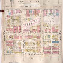
Title
-
Sanborn Map, Kansas City, Vol. 3, 1909-1950, Page p321
-
Description
-
A portion of Kansas City from E. 17th Street south to E. 19th Street Terrace and from Garfield Avenue east to Olive, showing buildings, streets, and additions. Large numbers at edges of page refer to page with adjoining area.
-
Date
-
1909/1950
-
Object Type
-
Map
-
-
Title
-
Sanborn Map, Kansas City, Vol. 3, 1909-1957, Page p307
-
Description
-
A portion of Kansas City from Truman Road south to E. 17th Street and from Woodland Avenue east to Garfield Avenue, showing buildings, streets, and additions. Large numbers at edges of page refer to page with adjoining area.
-
Date
-
1909/1957
-
Object Type
-
Map
-
-
Title
-
Sanborn Map, Kansas City, Vol. 3, 1909-1957, Page p310
-
Description
-
A portion of Kansas City from Truman Road south to E. 17th Street and from Montgall Avenue east to Walrond Avenue, showing buildings, streets, and additions. Large numbers at edges of page refer to page with adjoining area.
-
Date
-
1909/1957
-
Object Type
-
Map
-

-
Title
-
Sanborn Map, Kansas City, Vol. 3, 1909-1957, Page p320
-
Description
-
A portion of Kansas City from E. 17th Street south to E. 19th Street Terrace and from Woodland Avenue east to Garfield Avenue, showing buildings, streets, and additions. Large numbers at edges of page refer to page with adjoining area.
-
Date
-
1909/1957
-
Object Type
-
Map
-

-
Title
-
Sanborn Map, Kansas City, Vol. 3, 1909-1957, Page p308
-
Description
-
A portion of Kansas City from Truman Road south to E. 17th Street and from Garfield Avenue east to Olive, showing buildings, streets, and additions. Large numbers at edges of page refer to page with adjoining area.
-
Date
-
1909/1957
-
Object Type
-
Map
-
-
Title
-
Sanborn Map, Kansas City, Vol. 3, 1909-1957, Page p317
-
Description
-
A portion of Kansas City from E. 17th Street south to E. 19th Street and from Troost east to Tracy, showing buildings, streets, and additions. Large numbers at edges of page refer to page with adjoining area.
-
Date
-
1909/1957
-
Object Type
-
Map
-

-
Title
-
Sanborn Map, Kansas City, Vol. 3, 1909-1950, Page p320
-
Description
-
A portion of Kansas City from E. 17th Street south to Mayfield Avenue and from Woodland Avenue east to Garfield Avenue, showing buildings, streets, and additions. Large numbers at edges of page refer to page with adjoining area.
-
Date
-
1909/1950
-
Object Type
-
Map
Pages

