Pages
-
-
Title
-
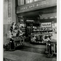
Union Station - News and Books
-
Description
-
View of the News and Books shop inside Union Station. Shelves filled with toys are on display.
-
Date
-
1915
-
Object Type
-
Photograph
-

-
Title
-
Union Station Interior
-
Description
-
Interior view of Union Station showing the passenger waiting area.
-
Object Type
-
Photograph
-

-
Title
-
Union Station Interior
-
Description
-
Interior view of Union Station. Signs reading Candy Shop and Book Shop can be seen.
-
Object Type
-
Photograph
-
-
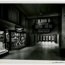
Title
-
Union Station Fred Harvey Restaurant, Store, and Shops
-
Description
-
Interior view of Union Station showing signs for the Fred Harvey restaurant, drug store, lunch room, book shop, candy shop, and cigar shop. The entrance to the drug store is on the left hand side of the image.
-
Object Type
-
Photograph
-
-
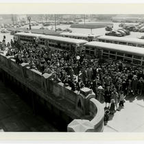
Title
-
Union Station Tour Crowd
-
Description
-
View of a crowd waiting for a tour of Union Station.
-
Date
-
1949
-
Object Type
-
Photograph
-
-
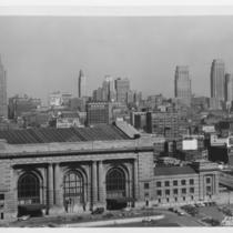
Title
-
Union Station and Skyline
-
Description
-
View looking north showing Union Station and the downtown skyline from the grounds of the Liberty Memorial.
-
Date
-
1945
-
Object Type
-
Photograph
-
-
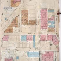
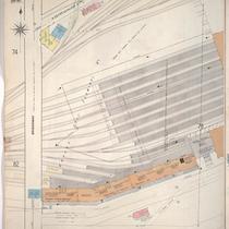
Title
-
Sanborn Map, Kansas City, Vol. 3, 1909-1957, Page p368
-
Description
-
A portion of Kansas City from E. 26th Street south to E. 28th Street and from Main Street east to McGee Street, showing buildings, streets, and additions. Large numbers at edges of page refer to page with adjoining area.
-
Date
-
1909/1957
-
Object Type
-
Map
-
-
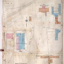
Title
-
Sanborn Map, Kansas City, Vol. 3, 1909-1957, Page p343
-
Description
-
A portion of Kansas City from E. 21st Street south to E. 23rd Street and from McGee east to McCoy Avenue, showing buildings, streets, and additions. Large numbers at edges of page refer to page with adjoining area.
-
Date
-
1909/1957
-
Object Type
-
Map
-

-
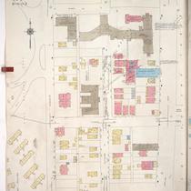
Title
-
Sanborn Map, Kansas City, Vol. 3, 1909-1950, Page p343
-
Description
-
A portion of Kansas City from E. 21st Street south to E. 23rd Street and from McGee east to McCoy Avenue, showing buildings, streets, and additions. Large numbers at edges of page refer to page with adjoining area.
-
Date
-
1909/1950
-
Object Type
-
Map
-

-
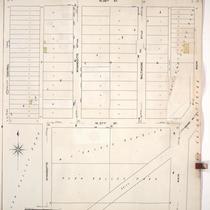
Title
-
Sanborn Map, Kansas City, Vol. 1, 1909-1938, Page p082
-
Description
-
A portion of Kansas City from about W. 24th Street south to W. 25th Street and from Jefferson Street east to Broadway, showing buildings, streets, railroads, and additions. Large numbers at edges of page refer to page with adjoining area.
-
Date
-
1909/1938
-
Object Type
-
Map
-

-
Title
-
Sanborn Map, Kansas City, Vol. 1, 1909-1938, Page p085
-
Description
-
A portion of Kansas City from Esplanade south to W. 26th Street and from Wyandotte east to Main, showing buildings, streets, and additions. Large numbers at edges of page refer to page with adjoining area.
-
Date
-
1909/1938
-
Object Type
-
Map
-

-
Title
-
Sanborn Map, Kansas City, Vol. 1A, 1939-1949, Page p143
-
Description
-
A portion of Kansas City from W. 23rd Street Trafficway south to W. 24th Street and from Madison Avenue east to W. Pennway, showing buildings and streets. Large numbers at edges of page refer to page with adjoining area.
-
Date
-
1939/1949
-
Object Type
-
Map
-
-
Title
-
Sanborn Map, Kansas City, Vol. 1A, 1939-1949, Page p155
-
Description
-
A portion of Kansas City from W. 28th Street south to W. 29th Street and from Wyandotte Street east to Main Street, showing buildings and streets. Large numbers at edges of page refer to page with adjoining area.
-
Date
-
1939/1949
-
Object Type
-
Map
-

-
Title
-
Sanborn Map, Kansas City, Vol. 1A, 1939-1949, Page p146
-
Description
-
A portion of Kansas City from W. 22nd Street south to W. 25th Street and from Broadway east to Main Street, showing buildings and streets. Large numbers at edges of page refer to page with adjoining area.
-
Date
-
1939/1949
-
Object Type
-
Map
-

-
Title
-
Sanborn Map, Kansas City, Vol. 1A, 1939-1949, Page p144
-
Description
-
A portion of Kansas City from W. 24th Street south to W. 25th Street and from Madison Avenue east to W. Pennway, showing buildings, railroads, and streets. Large numbers at edges of page refer to page with adjoining area.
-
Date
-
1939/1949
-
Object Type
-
Map
-

-
Title
-
Sanborn Map, Kansas City, Vol. 1, 1909-1938, Page p084
-
Description
-
A portion of Kansas City from Pershing Road south to W. 26th Street and from Broadway east to Wyandotte, showing buildings, streets, and additions. Large numbers at edges of page refer to page with adjoining area.
-
Date
-
1909/1938
-
Object Type
-
Map
-
-
Title
-
Sanborn Map, Kansas City, Vol. 1, 1909-1938, Page p086
-
Description
-
A portion of Kansas City from W. 26th Street south to W. 27th Street and from Central east to Main, showing buildings, streets, and additions. Large numbers at edges of page refer to page with adjoining area.
-
Date
-
1909/1938
-
Object Type
-
Map
-
-
Title
-
Sanborn Map, Kansas City, Vol. 1, 1909-1938, Page p077
-
Description
-
A portion of Kansas City from W. 22nd Street south to Pershing Road and from Broadway east to Wyandotte, showing buildings, streets, and additions. Large numbers at edges of page refer to page with adjoining area. Noted at top of sheet, "New Sheet April 1914 (formerly sheet 76)."
-
Date
-
1909/1938
-
Object Type
-
Map
Pages

