Pages
-

-
Title
-
Westport City Hall
-
Description
-
View looking east of the Westport City Hall building that once stood at the intersection of Pennsylvania Avenue and High (now W. 40th Terrace) Street. The building also served as stations for the fire and police departments. A car is parked along High Street.
-
Date
-
1929-11-02
-
Object Type
-
Photograph
-
-
Title
-
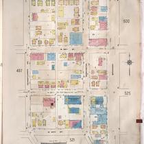
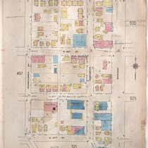
Sanborn Map, Kansas City, Vol. 4, 1909-1957, Page p498
-
Description
-
A portion of Kansas City from W. 38th Street south to W. 40th Street and from Pennsylvania Avenue east to Broadway, showing buildings, streets, and additions. Large numbers at edges of page refer to page with adjoining area.
-
Date
-
1909/1957
-
Object Type
-
Map
-

-
Title
-
Sanborn Map, Kansas City, Vol. 4, 1909-1950, Page p526
-
Description
-
A portion of Kansas City from E. 39th Street south to E. 40th Street and from Baltimore Avenue east to Walnut Street, showing buildings, streets, and additions. Large numbers at edges of page refer to page with adjoining area.
-
Date
-
1909/1950
-
Object Type
-
Map
-
-
Title
-
Sanborn Map, Kansas City, Vol. 4, 1909-1950, Page p524
-
Description
-
A portion of Kansas City from W. 42nd Street south to W. 43rd Street and from Pennsylvania Avenue east to Main Street, showing buildings, streets, and additions. Large numbers at edges of page refer to page with adjoining area.
-
Date
-
1909/1950
-
Object Type
-
Map
-
-
Title
-
Sanborn Map, Kansas City, Vol. 4, 1909-1950, Page p498
-
Description
-
A portion of Kansas City from W. 38th Street south to W. 40th Street and from Pennsylvania Avenue east to Broadway, showing buildings, streets, and additions. Large numbers at edges of page refer to page with adjoining area.
-
Date
-
1909/1950
-
Object Type
-
Map
-

-
Title
-
Sanborn Map, Kansas City, Vol. 4, 1909-1950, Page p525
-
Description
-
A portion of Kansas City from W. 39th Street south to Westport Road and from Broadway east to Baltimore Avenue, showing buildings, streets, and additions. Large numbers at edges of page refer to page with adjoining area.
-
Date
-
1909/1950
-
Object Type
-
Map
-

-
Title
-
Sanborn Map, Kansas City, Vol. 4, 1909-1950, Page p522
-
Description
-
A portion of Kansas City from Westport Road south to W. 43rd Street and from Pennsylvania Avenue east to Wornall Road, showing buildings, streets, and additions. Large numbers at edges of page refer to page with adjoining area.
-
Date
-
1909/1950
-
Object Type
-
Map
-

-
Title
-
Sanborn Map, Kansas City, Vol. 4, 1909-1950, Page p520
-
Description
-
A portion of Kansas City from W. 42nd Street south to W. 43rd Street and from Roanoke Road east to Pennsylvania Avenue, showing buildings, streets, and additions. Large numbers at edges of page refer to page with adjoining area.
-
Date
-
1909/1950
-
Object Type
-
Map
-

-
Title
-
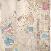
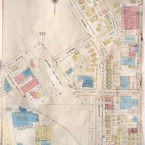
Sanborn Map, Kansas City, Vol. 4, 1909-1950, Page p523
-
Description
-
A portion of Kansas City from W. 40th Street south to Filmore Street and from Pennsylvania Avenue east to Baltimore Avenue, showing buildings, streets, and additions. Large numbers at edges of page refer to page with adjoining area.
-
Date
-
1909/1950
-
Object Type
-
Map
-

-
Title
-
Sanborn Map, Kansas City, Vol. 4, 1909-1950, Page p518
-
Description
-
A portion of Kansas City from W. 42nd Street south to W. 43rd Street and from Holly Street east to Roanoke Road, showing buildings, streets, and additions. Large numbers at edges of page refer to page with adjoining area.
-
Date
-
1909/1950
-
Object Type
-
Map
-

-
Title
-
Sanborn Map, Kansas City, Vol. 4, 1909-1950, Page p521
-
Description
-
A portion of Kansas City from W. 40th Street south to Westport Road and from Waddell Avenue east to Washington Street, showing buildings, streets, and additions. Large numbers at edges of page refer to page with adjoining area.
-
Date
-
1909/1950
-
Object Type
-
Map
-

-
Title
-
Westport City Hall
-
Description
-
View looking southwest along High (now W. 40th Terrace) Street showing the Westport City Hall building that once stood at its intersection with Pennsylvania Avenue. Cars parked along the street can be seen. The building also served as stations for the fire and police departments. A sign for Police Department No. 5 is displayed on the building. A Red Crown Gasoline station east of the building is in view. A portion of a Manor Baking Company building can be seen in the background.
-
Date
-
1930~
-
Object Type
-
Photograph
-

-
Title
-
J. W. Hunt Hardware Store at 523 Westport Road
-
Description
-
View looking southeast of the J. W. Hunt Hardware Store that once stood at 521-523 Westport Road. A car and two individuals can be seen outside of the store.
-
Date
-
1940~
-
Object Type
-
Photograph
-

-
Title
-
Sanborn Map, Kansas City, Vol. 4, 1909-1957, Page p521
-
Description
-
A portion of Kansas City from W. 40th Street south to Westport Road and from Waddell Avenue east to Washington, showing buildings, streets, and additions. Large numbers at edges of page refer to page with adjoining area.
-
Date
-
1909/1957
-
Object Type
-
Map
-

-
Title
-
Sanborn Map, Kansas City, Vol. 4, 1909-1957, Page p525
-
Description
-
A portion of Kansas City from W. 39th Street south to W. 40th Street and from Broadway east to Baltimore Avenue, showing buildings, streets, and additions. Large numbers at edges of page refer to page with adjoining area.
-
Date
-
1909/1957
-
Object Type
-
Map
-

-
Title
-
Sanborn Map, Kansas City, Vol. 4, 1909-1957, Page p518
-
Description
-
A portion of Kansas City from W. 42nd Street south to W. 43rd Street and from Holly Street east to Southwest Trafficway, showing buildings, streets, and additions. Large numbers at edges of page refer to page with adjoining area.
-
Date
-
1909/1957
-
Object Type
-
Map
-
-
Title
-
Sanborn Map, Kansas City, Vol. 4, 1909-1957, Page p524
-
Description
-
A portion of Kansas City from W. 41st Street south to W. 43rd Street and from Pennsylvania Avenue east to Main Street, showing buildings, streets, and additions. Large numbers at edges of page refer to page with adjoining area.
-
Date
-
1909/1957
-
Object Type
-
Map
-

-
Title
-
Sanborn Map, Kansas City, Vol. 4, 1909-1957, Page p520
-
Description
-
A portion of Kansas City from W. 42nd Street south to W. 43rd Street and from Roanoke Road east to Pennsylvania Avenue, showing buildings, streets, and additions. Large numbers at edges of page refer to page with adjoining area.
-
Date
-
1909/1957
-
Object Type
-
Map
-

-
Title
-
Broadway Boulevard from Valentine Road
-
Description
-
View looking south along Broadway Boulevard from south of its intersection with Valentine Road. Several cars traveling and parked along Broadway can be seen.
-
Date
-
1947~
-
Object Type
-
Photograph
-
-
Title
-
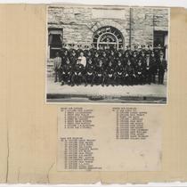
Hugh M. Dougherty Scrapbook #1, p.44
-
Description
-
Page 44 of the Hugh M. Dougherty Scrapbook #1. A group portrait of police officers posed outside of the Westport Police Station No. 5. A printed list of names of the pictured officers is attached to the page below the image.
-
Date
-
1932-08-28
-
Object Type
-
Photograph
Pages
