Pages
-
-
Title
-
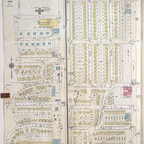
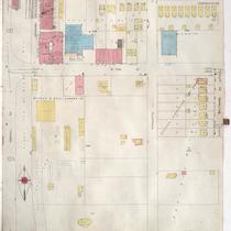
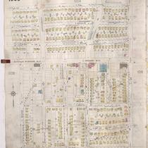
Sanborn Map, Kansas City, Vol. 9, 1930-1957, Page p1025
-
Description
-
A portion of Kansas City from Charlotte Street east to Troost Avenue and E. 70th Street south to E. 76th Street Terrace, showing buildings, streets, and additions. Large numbers at edges of page refer to page with adjoining area.
-
Date
-
1930/1957
-
Object Type
-
Map
-

-
Title
-
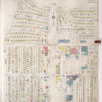
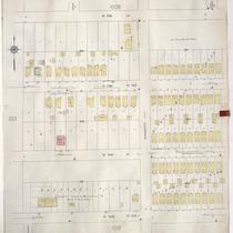
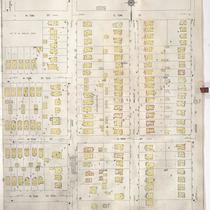
Sanborn Map, Kansas City, Vol. 9, 1930-1957, Page p1018
-
Description
-
A portion of Kansas City from E. 69th Street Terrace south to E. 73rd Street and from Oak Street east to Campbell Street, showing buildings, streets, and additions. Large numbers at edges of page refer to page with adjoining area. At top of map, "Add'l Sheet, Jan. 1935."
-
Date
-
1930/1957
-
Object Type
-
Map
-

-
Title
-
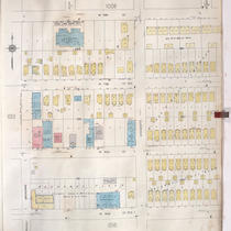
Sanborn Map, Kansas City, Vol. 9, 1930-1957, Page p1010
-
Description
-
A portion of Kansas City from E. 73rd Street south to E. 74th Street and from Main Street east to Grand Avenue, showing buildings, streets, and additions. Large numbers at edges of page refer to page with adjoining area.
-
Date
-
1930/1957
-
Object Type
-
Map
-
-
Title
-
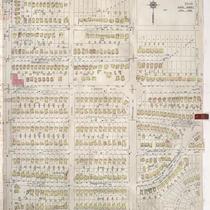
Sanborn Map, Kansas City, Vol. 9, 1930-1957, Page p1008
-
Description
-
A portion of Kansas City from W. 70th Street south to W. 73rd Street and from Jefferson Street east to Baltimore Avenue, showing buildings, streets, and additions. Large numbers at edges of page refer to page with adjoining area. Country Club Lumber Company is noted on the map, but the 1939 city directory calls it the Snyder-Kunkel Lumber Company, 321 W. Gregory Blvd.
-
Date
-
1930/1957
-
Object Type
-
Map
-
-
Title
-
Sanborn Map, Kansas City, Vol. 9, 1930-1957, Page p1014
-
Description
-
A portion of Kansas City from W. 73rd Street south to W. 74th Street Terrace and from Broadway east to Wyandotte Street, showing buildings, streets, and additions. Large numbers at edges of page refer to page with adjoining area.
-
Date
-
1930/1957
-
Object Type
-
Map
-
-
Title
-
Sanborn Map, Kansas City, Vol. 9, 1930-1941, Page p1018
-
Description
-
A portion of Kansas City from E. 69th Street Terrace south to E. 73rd Street and from Oak Street east to Campbell Street, showing buildings, streets, and additions. Large numbers at edges of page refer to page with adjoining area. At top of map, "Add'l Sheet, Jan. 1935."
-
Date
-
1930/1941
-
Object Type
-
Map
-
-
Title
-
Sanborn Map, Kansas City, Vol. 9, 1930-1941, Page p1016
-
Description
-
A portion of Kansas City from W. 74th Street Terrace south to about W. 76th Street and from Wornall Road east to Baltimore Avenue, showing buildings, streets, and additions. Large numbers at edges of page refer to page with adjoining area.
-
Date
-
1930/1941
-
Object Type
-
Map
-
-
Title
-
Sanborn Map, Kansas City, Vol. 9, 1930-1941, Page p1014
-
Description
-
A portion of Kansas City from W. 73rd Street south to W. 74th Street Terrace and from Broadway east to Wyandotte Street, showing buildings, streets, and additions. Large numbers at edges of page refer to page with adjoining area.
-
Date
-
1930/1941
-
Object Type
-
Map
-

-
Title
-
Sanborn Map, Kansas City, Vol. 9, 1930-1957, Page p1016
-
Description
-
A portion of Kansas City from W. 74th Street Terrace south to about W. 76th Street and from Wornall Road east to Baltimore Avenue, showing buildings, streets, and additions. Large numbers at edges of page refer to page with adjoining area.
-
Date
-
1930/1957
-
Object Type
-
Map
-

-
Title
-
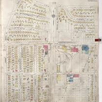
Sanborn Map, Kansas City, Vol. 9, 1930-1957, Page p1023
-
Description
-
A portion of Kansas City from W. 77th Street south to W. 79th Street Terrace and from Pennsylvania Avenue east to Main Street, showing buildings, streets, and additions. Large numbers at edges of page refer to page with adjoining area. At top of map, "A. May 1941."
-
Date
-
1930/1957
-
Object Type
-
Map
-
-
Title
-
Sanborn Map, Kansas City, Vol. 9, 1930-1957, Page p1024
-
Description
-
A portion of Kansas City from E. 73rd Street south to E. 76th Street Oak Street east to Charlotte Street, showing buildings, streets, and additions. Large numbers at edges of page refer to page with adjoining area.
-
Date
-
1930/1957
-
Object Type
-
Map
-
-
Title
-
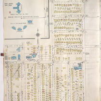
Sanborn Map, Kansas City, Vol. 9, 1930-1957, Page p1017
-
Description
-
A portion of Kansas City from E. 73rd Street south to E. 75th Street and from Baltimore Avenue east to Oak Street, showing buildings, streets, and additions. Large numbers at edges of page refer to page with adjoining area. At top of map, "Add'l Sheet, Jan. 1934."
-
Date
-
1930/1957
-
Object Type
-
Map
-

-
Title
-
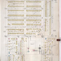
Sanborn Map, Kansas City, Vol. 9, 1930-1957, Page p1009
-
Description
-
A portion of Kansas City from E. 70th Street south to E. 73rd Street and from Baltimore Avenue east to Oak Street, showing buildings, streets, and additions. Large numbers at edges of page refer to page with adjoining area.
-
Date
-
1930/1957
-
Object Type
-
Map
-
-
Title
-
Sanborn Map, Kansas City, Vol. 9, 1930-1941, Page p1009
-
Description
-
A portion of Kansas City from E. 70th Street south to E. 73rd Street and from Baltimore Avenue east to Oak Street, showing buildings, streets, and additions. Large numbers at edges of page refer to page with adjoining area.
-
Date
-
1930/1941
-
Object Type
-
Map
-
-
Title
-
Sanborn Map, Kansas City, Vol. 9, 1930-1941, Page p1010
-
Description
-
A portion of Kansas City from E. 73rd Street south to E. 74th Street and from Main Street east to Grand Avenue, showing buildings, streets, and additions. Large numbers at edges of page refer to page with adjoining area.
-
Date
-
1930/1941
-
Object Type
-
Map
-

-
Title
-
Sanborn Map, Kansas City, Vol. 9, 1930-1941, Page p1023
-
Description
-
A portion of Kansas City from W. 77th Street south to W. 79th Street Terrace and from Pennsylvania Avenue east to Main Street, showing buildings, streets, and additions. Large numbers at edges of page refer to page with adjoining area. At top of map, "A. May 1941."
-
Date
-
1930/1941
-
Object Type
-
Map
-
-
Title
-
Sanborn Map, Kansas City, Vol. 9, 1930-1941, Page p1008
-
Description
-
A portion of Kansas City from W. 70th Street south to W. 73rd Street and from Jefferson Street east to Baltimore Avenue, showing buildings, streets, and additions. Large numbers at edges of page refer to page with adjoining area. Country Club Lumber Company is noted on the map, but the 1939 city directory calls it the Snyder-Kunkel Lumber Company, 321 W. Gregory Blvd.
-
Date
-
1930/1941
-
Object Type
-
Map
-

-
Title
-
Sanborn Map, Kansas City, Vol. 9, 1930-1941, Page p1017
-
Description
-
A portion of Kansas City from E. 73rd Street south to E. 75th Street and from Baltimore Avenue east to Oak Street, showing buildings, streets, and additions. Large numbers at edges of page refer to page with adjoining area. At top of map, "Add'l Sheet, Jan. 1934."
-
Date
-
1930/1941
-
Object Type
-
Map
-

-
Title
-
236 West 73rd Terrace
-
Description
-
Photograph circa 1980s of a house at 236 West 73rd Terrace. The property was zoned for commercial used and served as the offices for a variety of businesses.
-
Date
-
1980~/1989~
-
Object Type
-
Photograph
-

-
Title
-
Waldo Water Tower
-
Description
-
Photograph of the Waldo Water Tower in Tower Park in the 1980s. The water tower was constructed in 1920 and used until 1957, and was originally called the Frank T. Riley Memorial after the owner of the property on which it was built.
-
Date
-
1980~/1989~
-
Object Type
-
Photograph
Pages
