-

-
Title
-
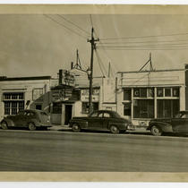
3203-3209 Southwest Boulevard - Last Chance Tavern (Saloon)
-
Description
-
View looking east of the buildings that once stood at 3203-3209 Southwest Boulevard. The Last Chance Tavern (or Saloon) at 3205 Southwest Boulevard, Goulding's, and the Last Chance Cafe are in view. Cars parked on the street can and pedestrians be seen. The state line is indicated with an arrow and the Missouri and Kansas sides are labeled.
-
Date
-
1939-07
-
Object Type
-
Photograph
-
-
Title
-
3203-3209 Southwest Boulevard - Last Chance Tavern (Saloon)
-
Description
-
View looking east of the buildings that once stood at 3203-3209 Southwest Boulevard. The Last Chance Tavern (or Saloon) at 3205 Southwest Boulevard, Goulding's, and the Last Chance Cafe are in view. Cars parked on the street can be seen.
-
Date
-
1950-04
-
Object Type
-
Photograph
-

-
Title
-
3203-3211 Southwest Boulevard - Last Chance Tavern (Saloon)
-
Description
-
View looking east of the buildings that once stood at 3203-3211 Southwest Boulevard. The Last Chance Tavern (or Saloon) at 3205 Southwest Boulevard, Goulding's, and the Last Chance Cafe are in view. Cars parked on the street can be seen.
-
Date
-
1950-04
-
Object Type
-
Photograph
-

-
Title
-
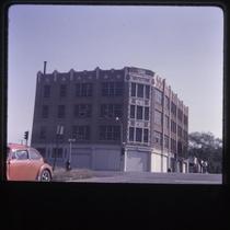
2540 West Pennway Street
-
Description
-
Photograph of architectural details on a commercial building at 2540 West Pennway circa 1980. National Store Fixture Company, a building tenant at the time of the photograph, declared bankruptcy in 1983 and the building was sold to a developer in 1984. The building was formerly a bottling factory and warehouse for Coca-Cola.
-
Date
-
1980~/1989~
-
Object Type
-
Photograph
-

-
Title
-
The BMA Tower
-
Description
-
Aerial view of the Business Men's Assurance (BMA) Tower at 700 W. 31st street. Cars can be seen traveling on 31st Street along the bottom of the image and on Southwest Trafficway along the left hand side. Penn Valley Park and downtown Kansas City can be seen in the background.
-
Date
-
1963~
-
Object Type
-
Photograph
-
-
Title
-
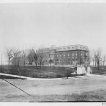
Saint Joseph's Orphan Home
-
Description
-
View of the St. Joseph's Orphan Home, once located at Summit Street and Karnes Boulevard (31st Street).
-
Date
-
1910~
-
Object Type
-
Photograph
-
-
Title
-
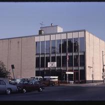
Armed Services Building
-
Description
-
Photograph of the Armed Services Building at 2420 Broadway in the early 1980s. The building served as a recruiting station and entry processing station for the U.S. Armed Forces, handling medical an aptitude exams and background checks for incoming recruits from the 1960s through 1993. The building was later converted to a residential condominium building.
-
Date
-
1980~/1989~
-
Object Type
-
Photograph
-
-
Title
-
514 West 26th Street
-
Description
-
Photograph of a commercial building at the northeast corner of 26th and Broadway in the early 1980s. The building served as a garment factory at the time of the photo, and was sold to Strahm Printing ; Mailing in 1984.
-
Date
-
1980~/1989~
-
Object Type
-
Photograph
-

-
Title
-
Scout Statue
-
Description
-
An autochrome photograph of the Scout Statue, as seen from atop Scout Hill in Penn Valley Park, looking north. Downtown Kansas City, Missouri is picture in the background.
-
Date
-
1938-09-08
-
Object Type
-
Photograph
-

-
Title
-
Scout Statue
-
Description
-
An autochrome photograph of the Scout Statue, as seen from atop Scout Hill in Penn Valley Park, looking north. Downtown Kansas City, Missouri is picture in the background.
-
Date
-
1932-10-20
-
Object Type
-
Photograph
-

-
Title
-
Penn Valley Park from Scout Hill
-
Description
-
An autochrome photograph of Penn Valley Park, as seen looking northeast from Scout Hill.
-
Date
-
1932-06-15
-
Object Type
-
Photograph
-

-
Title
-
Penn Valley Lake
-
Description
-
An autochrome photograph faceing north-northeast across Penn Valley Lake with downtown Kansas City, Missouri in the background.
-
Date
-
1932-10-15
-
Object Type
-
Photograph
-

-
Title
-
William Gillis Farm, 600 Acres, 1846
-
Description
-
Pictorial map showing the 1846 boundaries of the farm of William Gillis, an early settler and business leader in Kansas City. The farm totalled 600 acres, and the map shows the location of the Gillis farmhouse. Twentieth-century streets, parks, bridges, and neighborhoods are superimposed over the image of the farm.
-
Date
-
1927
-
Object Type
-
Map
-

-
Title
-
Mexicans in Kansas City: The First Generation, 1900-1920
-
Description
-
Article describing the push / pull factors that drew Mexican migrants to the Kansas City region in the first two decades of the twentieth century. Revolution in Mexico, lack of migration from Europe due to World War 1, and labor shortages for meat-packing, construction, and railroad work all played a crucial role. Describes the communities the migrants created in the region, including the Santa Fe Railroad Camp at Argentine, West Bottoms and Armourdale, and Rosedale in Kansas, and the Westside Bluffs, Burlington railyard, and Sheffield.
-
Date
-
1989
-
Object Type
-
Magazine
-
-
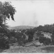
Title
-
Penn Valley Park
-
Description
-
View looking northwest from an elevated position above Broadway Boulevard or Penn Valley Drive as it passes through Penn Valley Park. Cars travelling north along the street can be seen.
-
Date
-
1920~
-
Object Type
-
Photograph
