Pages
-
-
Title
-
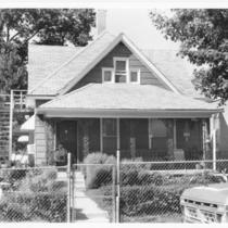
Walt Disney Residence
-
Description
-
View of the house occupied by Walt Disney and has family during their residence in Kansas City, Missouri, located at 3028 Bellefontaine Avenue.
-
Date
-
1989
-
Object Type
-
Photograph
-
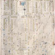
-
Title
-
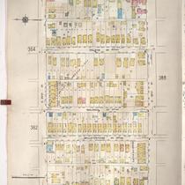
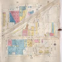
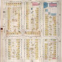
Sanborn Map, Kansas City, Vol. 3, 1909-1957, Page p387
-
Description
-
A portion of Kansas City from E. 25th Street south to E. 26th Street and from Agnes Avenue east to Indiana Avenue, showing buildings, streets, and additions. Large numbers at edges of page refer to page with adjoining area.
-
Date
-
1909/1957
-
Object Type
-
Map
-
-
Title
-
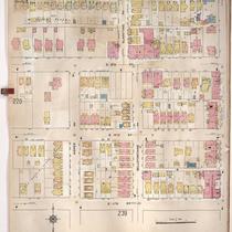
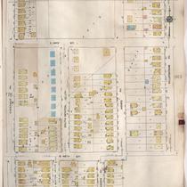
Sanborn Map, Kansas City, Vol. 2, 1909-1937, Page p221
-
Description
-
A portion of Kansas City from E. 8th Street south to E. 11th Street and from Agnes Avenue east to Benton Boulevard, showing buildings, streets, and additions. Large numbers at edges of page refer to page with adjoining area.
-
Date
-
1909/1937
-
Object Type
-
Map
-
-
Title
-
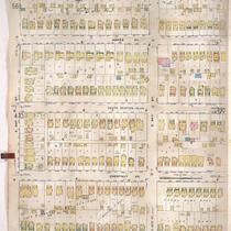
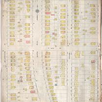
Sanborn Map, Kansas City, Vol. 4, 1909-1957, Page p489
-
Description
-
A portion of Kansas City from E. 33rd Street south to E. 34th Street and from Montgall Avenue east to Bellefontaine Avenue, showing buildings, streets, and additions. Large numbers at edges of page refer to page with adjoining area.
-
Date
-
1909/1957
-
Object Type
-
Map
-
-
Title
-
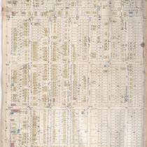
Sanborn Map, Kansas City, Vol. 3, 1909-1957, Page p324
-
Description
-
A portion of Kansas City from E. 17th Street south to E. 19th Street and from Agnes Avenue east to College Avenue, showing buildings, streets, and additions. Large numbers at edges of page refer to page with adjoining area.
-
Date
-
1909/1957
-
Object Type
-
Map
-
-
Title
-
Sanborn Map, Kansas City, Vol. 6, 1917-1957, Page p778
-
Description
-
A portion of northeastern Kansas City from E. 44th Street south to E. 45th Street and from Chestnut Avenue east to Bellefontaine Avenue, showing buildings, streets, and additions. Large numbers at edges of page refer to page with adjoining area.
-
Date
-
1917/1957
-
Object Type
-
Map
-
-
Title
-
Sanborn Map, Kansas City, Vol. 6, 1917-1957, Page p849
-
Description
-
A portion of Kansas City from just north of E. 44th Street south to E. 45th Street and from Bellefontaine Avenue east to Indiana Avenue, showing buildings, streets, and additions. Large numbers at edges of page refer to page with adjoining area. Noted at top of page, "New Sheet Dec. 1931."
-
Date
-
1917/1957
-
Object Type
-
Map
-

-
Title
-
Sanborn Map, Kansas City, Vol. 6, 1917-1957, Page p770
-
Description
-
A portion of northeastern Kansas City from E. 41st Street south to E. 42nd Street and from Chestnut Avenue east to Bellefontaine Avenue, showing buildings, streets, and additions. Large numbers at edges of page refer to page with adjoining area.
-
Date
-
1917/1957
-
Object Type
-
Map
-
-
Title
-
Sanborn Map, Kansas City, Vol. 6, 1917-1957, Page p853
-
Description
-
A portion of Kansas City, Missouri, from E. 55th Street south to E. 58th Street and from Prospect Avenue east to Walrond Avenue, showing buildings, streets, and additions. Large numbers at edges of page refer to page with adjoining area. Noted at top of map, "(786) Add'l Sheet, Nov. 1935."
-
Date
-
1917/1957
-
Object Type
-
Map
-
-
Title
-
Sanborn Map, Kansas City, Vol. 6, 1917-1957, Page p769
-
Description
-
A portion of northeastern Kansas City from E. 39th Street south to about E. 41st Street and from Chestnut Avenue east to Bellefontaine Avenue, showing buildings, streets, and additions. Large numbers at edges of page refer to page with adjoining area.
-
Date
-
1917/1957
-
Object Type
-
Map
-

-
Title
-
Sanborn Map, Kansas City, Vol. 6, 1917-1957, Page p784
-
Description
-
A portion of northeastern Kansas City from E. 49th Street south to E. 51st Street and from South Benton Boulevard east to Walrond Avenue, showing buildings, streets, and additions. Large numbers at edges of page refer to page with adjoining area.
-
Date
-
1917/1957
-
Object Type
-
Map
-
-
Title
-
Sanborn Map, Kansas City, Vol. 6, 1917-1957, Page p761
-
Description
-
A portion of northeastern Kansas City from E. 36th Street south to about E. 38th Street and from Bellefontaine Avenue east to Indiana Avenue, showing buildings, streets, and additions. Large numbers at edges of page refer to page with adjoining area.
-
Date
-
1917/1957
-
Object Type
-
Map
-
-
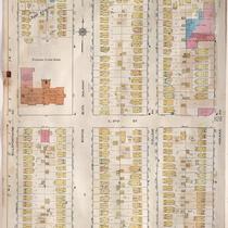
Title
-
Sanborn Map, Kansas City, Vol. 2, 1909-1937, Page p179
-
Description
-
A portion of Kansas City from Lexington Avenue south to E. Missouri Avenue and from Highland Avenue east to Maple Avenue, showing buildings, streets and additions. Another portion from Anderson Avenue south to Smart Avenue and from Bellefontaine Avenue east to Benton Boulevard is shown. Large numbers at edges of page refer to page with adjoining area.
-
Date
-
1909/1937
-
Object Type
-
Map
-
-
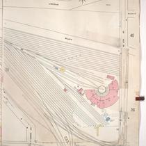
Title
-
Sanborn Map, Kansas City, Vol. 1, 1909-1938, Page p030
-
Description
-
A portion of Kansas City from Union Avenue south to W. 12th Street and from Santa Fe east to Lincoln, showing buildings, streets, railroads, and additions. Large numbers at edges of page refer to page with adjoining area.
-
Date
-
1909/1938
-
Object Type
-
Map
-

-
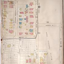
Title
-
Sanborn Map, Kansas City, Vol. 5, 1909-1938, Page p710
-
Description
-
A portion of Kansas City in the Blue Valley Industrial District, showing buildings, streets, railroads, and additions. Large numbers at edges of page refer to page with adjoining area. At the top of page, "Add'l Sheet, Aug. 1912."
-
Date
-
1909/1938
-
Object Type
-
Map
-
-
Title
-
Sanborn Map, Kansas City, Vol. 6, 1917-1957, Page p786
-
Description
-
A portion of northeastern Kansas City from E. 51st Street south to E. 54th Street and from Prospect Avenue east to Walrond Avenue, showing buildings, streets, and additions. Large numbers at edges of page refer to page with adjoining area. At top of sheet reads "New Sheet Nov. 1935 X."
-
Date
-
1917/1957
-
Object Type
-
Map
-

-
Title
-
Sanborn Map, Kansas City, Vol. 6, 1917-1957, Page p856
-
Description
-
A portion of Kansas City, Missouri, from E. 58th Street south to E. 61st Street and from Prospect Avenue east to Walrond Avenue, showing buildings, streets, and additions. Large numbers at edges of page refer to page with adjoining area. Noted at top of map, "Add'l Sheet, Nov. 1937."
-
Date
-
1917/1957
-
Object Type
-
Map
-
-
Title
-
Sanborn Map, Kansas City, Vol. 6, 1917-1957, Page p760
-
Description
-
A portion of Kansas City from E. 35th Street south to E. 36th Street and from Bellefontaine Avenue east to Indiana Avenue, showing buildings, streets, and additions. Large numbers at edges of page refer to page with adjoining area.
-
Date
-
1917/1957
-
Object Type
-
Map
-

-
Title
-
Sanborn Map, Kansas City, Vol. 6, 1917-1957, Page p762
-
Description
-
A portion of northeastern Kansas City from E. 38th Street south to about E. 40th Street and from Bellefontaine Avenue east to Indiana Avenue, showing buildings, streets, and additions. Large numbers at edges of page refer to page with adjoining area.
-
Date
-
1917/1957
-
Object Type
-
Map
-
-
Title
-
Sanborn Map, Kansas City, Vol. 6, 1917-1957, Page p780
-
Description
-
A portion of northeastern Kansas City from about E. 45th Street south to E. 47th Street and from Chestnut Avenue east to Bellefontaine Avenue, showing buildings, streets, and additions. Large numbers at edges of page refer to page with adjoining area.
-
Date
-
1917/1957
-
Object Type
-
Map
Pages
