Pages
-
-
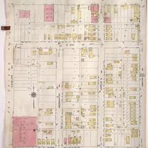
Title
-
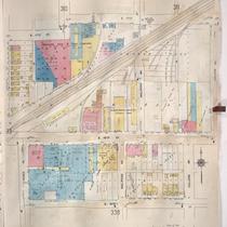
Sanborn Map, Kansas City, Vol. 3, 1909-1957, Page p306
-
Description
-
A portion of Kansas City from Truman Road south to E. 17th Street and from Tracy Avenue east to The Paseo, showing buildings, streets, and additions. Large numbers at edges of page refer to page with adjoining area.
-
Date
-
1909/1957
-
Object Type
-
Map
-

-
Title
-
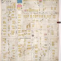
Sanborn Map, Kansas City, Vol. 5, 1909-1938, Page p671
-
Description
-
A portion of Kansas City from E. 17th Street south to E. 20th Street and from Kensington Avenue east to Lawn Avenue, showing buildings, streets, and additions. Large numbers at edges of page refer to page with adjoining area.
-
Date
-
1909/1938
-
Object Type
-
Map
-
-
Title
-
Sanborn Map, Kansas City, Vol. 5, 1909-1938, Page p672
-
Description
-
A portion of Kansas City from E. 17th Street south to E. 20th Street and from Lawn Avenue east to Brighton Avenue, showing buildings, streets, and additions. Large numbers at edges of page refer to page with adjoining area.
-
Date
-
1909/1938
-
Object Type
-
Map
-
-
Title
-
Sanborn Map, Kansas City, Vol. 5, 1909-1938, Page p718
-
Description
-
A portion of Kansas City from E. 15th Street south to E. 17th Street and from Drury Avenue east to Topping Avenue, showing buildings, streets, and additions. Large numbers at edges of page refer to page with adjoining area. At the top of page, "Add'l Sheet, Dec. 1916."
-
Date
-
1909/1938
-
Object Type
-
Map
-

-
Title
-
Sanborn Map, Kansas City, Vol. 3, 1909-1957, Page p316
-
Description
-
A portion of Kansas City from E. 17th Street south to E. 19th Street and from Charlotte east to Harrison, showing buildings, streets, and additions. Large numbers at edges of page refer to page with adjoining area.
-
Date
-
1909/1957
-
Object Type
-
Map
-

-
Title
-
Sanborn Map, Kansas City, Vol. 5, 1909-1938, Page p719
-
Description
-
A portion of Kansas City from E. 15th Street south to E. 17th Street and from Topping Avenue east to White Avenue, showing buildings, streets, and additions. Large numbers at edges of page refer to page with adjoining area. At the top of page, "Add'l Sheet, Dec. 1916."
-
Date
-
1909/1938
-
Object Type
-
Map
-

-
Title
-
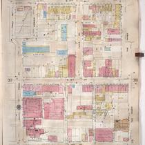
Sanborn Map, Kansas City, Vol. 3, 1909-1957, Page p302
-
Description
-
A portion of Kansas City from Truman Road south to E. 17th Street and from Grand Avenue east to Locust, showing buildings, streets, and additions. Large numbers at edges of page refer to page with adjoining area.
-
Date
-
1909/1957
-
Object Type
-
Map
-

-
Title
-
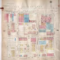
Sanborn Map, Kansas City, Vol. 3, 1909-1957, Page p314
-
Description
-
A portion of Kansas City from E. 17th Street south to E. 19th Street and from Grand Avenue east to Locust, showing buildings, streets, and additions. Large numbers at edges of page refer to page with adjoining area.
-
Date
-
1909/1957
-
Object Type
-
Map
-
-
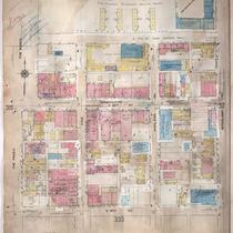
Title
-
Sanborn Map, Kansas City, Vol. 3, 1909-1950, Page p319
-
Description
-
A portion of Kansas City from E. 17th Street south to E. 19th Street and from The Paseo east to Woodland Avenue, showing buildings, streets, and additions. Large numbers at edges of page refer to page with adjoining area.
-
Date
-
1909/1950
-
Object Type
-
Map
-
-
Title
-
Sanborn Map, Kansas City, Vol. 3, 1909-1957, Page p324
-
Description
-
A portion of Kansas City from E. 17th Street south to E. 19th Street and from Agnes Avenue east to College Avenue, showing buildings, streets, and additions. Large numbers at edges of page refer to page with adjoining area.
-
Date
-
1909/1957
-
Object Type
-
Map
-
-
Title
-
Sanborn Map, Kansas City, Vol. 3, 1909-1957, Page p318
-
Description
-
A portion of Kansas City from E. 17th Street south to E. 19th Street and from Tracy Avenue east to The Paseo, showing buildings, streets, and additions. Large numbers at edges of page refer to page with adjoining area.
-
Date
-
1909/1957
-
Object Type
-
Map
-

-
Title
-
Sanborn Map, Kansas City, Vol. 3, 1909-1957, Page p322
-
Description
-
A portion of Kansas City from E. 17th Street south to E. 19th Street and from Olive east to Montgall Avenue, showing buildings, streets, and additions. Large numbers at edges of page refer to page with adjoining area. Formerly, the City Ice Company was in this section of town.
-
Date
-
1909/1957
-
Object Type
-
Map
-

-
Title
-
Sanborn Map, Kansas City, Vol. 3, 1909-1957, Page p313
-
Description
-
A portion of Kansas City from E. 17th Street south to E. 19th Street and from Main Street east to Grand Avenue, showing buildings, streets, and additions. Large numbers at edges of page refer to page with adjoining area.
-
Date
-
1909/1957
-
Object Type
-
Map
-
-
Title
-
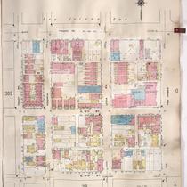
Sanborn Map, Kansas City, Vol. 3, 1909-1950, Page p305
-
Description
-
A portion of Kansas City from Truman Road south to E. 17th Street and from Troost Avenue east to Tracy Avenue, showing buildings, streets, and additions. Large numbers at edges of page refer to page with adjoining area.
-
Date
-
1909/1950
-
Object Type
-
Map
-

-
Title
-
Sanborn Map, Kansas City, Vol. 3, 1909-1950, Page p312
-
Description
-
A portion of Kansas City from Truman Road south to E. 17th Street and from Bales Avenue east to Cleveland Avenue, showing buildings, streets, and additions. Large numbers at edges of page refer to page with adjoining area.
-
Date
-
1909/1950
-
Object Type
-
Map
-

-
Title
-
Sanborn Map, Kansas City, Vol. 3, 1909-1950, Page p301
-
Description
-
A portion of Kansas City from Truman Road south to E. 17th Street and from Main Street east to Grand Avenue, showing buildings, streets, and additions. Large numbers at edges of page refer to page with adjoining area.
-
Date
-
1909/1950
-
Object Type
-
Map
-
-
Title
-
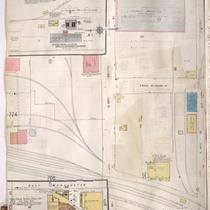
Sanborn Map, Kansas City, Vol. 5, 1909-1938, Page p707
-
Description
-
A portion of Kansas City at the intersection of E. 39th Street and Ewing Avenue, showing buildings, streets, railroads, and additions. Large numbers at edges of page refer to page with adjoining area.
-
Date
-
1909/1938
-
Object Type
-
Map
-

-
Title
-
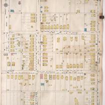
Sanborn Map, Kansas City, Vol. 5, 1909-1938, Page p667
-
Description
-
A portion of Kansas City from E. 15th Street south to E. 17th Street and from Poplar Avenue east to Denver Avenue, showing buildings, streets, and additions. Large numbers at edges of page refer to page with adjoining area.
-
Date
-
1909/1938
-
Object Type
-
Map
-

-
Title
-
Sanborn Map, Kansas City, Vol. 5, 1909-1938, Page p699
-
Description
-
A portion of Kansas City from E. 16th Street south to E. 17th Street and from Ewing Avenue east to Bristol Avenue, showing buildings, streets, railroads, and additions. Large numbers at edges of page refer to page with adjoining area.
-
Date
-
1909/1938
-
Object Type
-
Map
-
-
Title
-
Sanborn Map, Kansas City, Vol. 5, 1909-1938, Page p663
-
Description
-
A portion of Kansas City from E. 15th Street south to E. 17th Street and from Cleveland Avenue east to Norton Avenue, showing buildings, streets, and additions. Large numbers at edges of page refer to page with adjoining area.
-
Date
-
1909/1938
-
Object Type
-
Map
Pages
