Pages
-

-
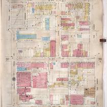
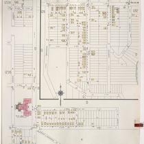
Title
-
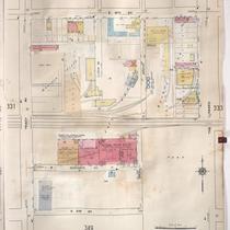
Sanborn Map, Kansas City, Vol. 5, 1909-1938, Page p671
-
Description
-
A portion of Kansas City from E. 17th Street south to E. 20th Street and from Kensington Avenue east to Lawn Avenue, showing buildings, streets, and additions. Large numbers at edges of page refer to page with adjoining area.
-
Date
-
1909/1938
-
Object Type
-
Map
-

-
Title
-
Sanborn Map, Kansas City, Vol. 5, 1909-1938, Page p672
-
Description
-
A portion of Kansas City from E. 17th Street south to E. 20th Street and from Lawn Avenue east to Brighton Avenue, showing buildings, streets, and additions. Large numbers at edges of page refer to page with adjoining area.
-
Date
-
1909/1938
-
Object Type
-
Map
-

-
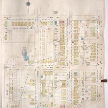
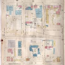
Title
-
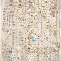
Sanborn Map, Kansas City, Vol. 3, 1909-1957, Page p316
-
Description
-
A portion of Kansas City from E. 17th Street south to E. 19th Street and from Charlotte east to Harrison, showing buildings, streets, and additions. Large numbers at edges of page refer to page with adjoining area.
-
Date
-
1909/1957
-
Object Type
-
Map
-
-
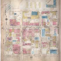
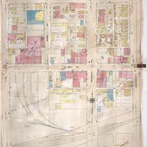
Title
-
Sanborn Map, Kansas City, Vol. 3, 1909-1957, Page p340
-
Description
-
A portion of Kansas City from E. 19th Street south to E. 21st Street and from Bales Avenue east to Cleveland Avenue, showing buildings, streets, and additions. Large numbers at edges of page refer to page with adjoining area.
-
Date
-
1909/1957
-
Object Type
-
Map
-
-
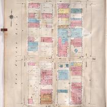
Title
-
Sanborn Map, Kansas City, Vol. 3, 1909-1957, Page p314
-
Description
-
A portion of Kansas City from E. 17th Street south to E. 19th Street and from Grand Avenue east to Locust, showing buildings, streets, and additions. Large numbers at edges of page refer to page with adjoining area.
-
Date
-
1909/1957
-
Object Type
-
Map
-
-
Title
-
Sanborn Map, Kansas City, Vol. 3, 1909-1950, Page p319
-
Description
-
A portion of Kansas City from E. 17th Street south to E. 19th Street and from The Paseo east to Woodland Avenue, showing buildings, streets, and additions. Large numbers at edges of page refer to page with adjoining area.
-
Date
-
1909/1950
-
Object Type
-
Map
-
-
Title
-
Sanborn Map, Kansas City, Vol. 3, 1909-1957, Page p324
-
Description
-
A portion of Kansas City from E. 17th Street south to E. 19th Street and from Agnes Avenue east to College Avenue, showing buildings, streets, and additions. Large numbers at edges of page refer to page with adjoining area.
-
Date
-
1909/1957
-
Object Type
-
Map
-
-
Title
-
Sanborn Map, Kansas City, Vol. 3, 1909-1957, Page p318
-
Description
-
A portion of Kansas City from E. 17th Street south to E. 19th Street and from Tracy Avenue east to The Paseo, showing buildings, streets, and additions. Large numbers at edges of page refer to page with adjoining area.
-
Date
-
1909/1957
-
Object Type
-
Map
-
-
Title
-
Sanborn Map, Kansas City, Vol. 3, 1909-1957, Page p333
-
Description
-
A portion of Kansas City from E. 19th Street south to E. 21st Street and from The Paseo east to Woodland Avenue, showing buildings, streets, and additions. Large numbers at edges of page refer to page with adjoining area.
-
Date
-
1909/1957
-
Object Type
-
Map
-
-
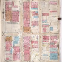
Title
-
Sanborn Map, Kansas City, Vol. 3, 1909-1957, Page p322
-
Description
-
A portion of Kansas City from E. 17th Street south to E. 19th Street and from Olive east to Montgall Avenue, showing buildings, streets, and additions. Large numbers at edges of page refer to page with adjoining area. Formerly, the City Ice Company was in this section of town.
-
Date
-
1909/1957
-
Object Type
-
Map
-
-
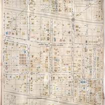
Title
-
Sanborn Map, Kansas City, Vol. 3, 1909-1957, Page p313
-
Description
-
A portion of Kansas City from E. 17th Street south to E. 19th Street and from Main Street east to Grand Avenue, showing buildings, streets, and additions. Large numbers at edges of page refer to page with adjoining area.
-
Date
-
1909/1957
-
Object Type
-
Map
-

-
Title
-
Sanborn Map, Kansas City, Vol. 3, 1909-1957, Page p330
-
Description
-
A portion of Kansas City from E. 19th Street south to E. 21st Street and from Charlotte east to Harrison, showing buildings, streets, and additions. Large numbers at edges of page refer to page with adjoining area.
-
Date
-
1909/1957
-
Object Type
-
Map
-
-
Title
-
Sanborn Map, Kansas City, Vol. 3, 1909-1957, Page p332
-
Description
-
A portion of Kansas City from E. 19th Street south to E. 21st Street and from Tracy Avenue east to The Paseo, showing buildings, streets, and additions. Large numbers at edges of page refer to page with adjoining area.
-
Date
-
1909/1957
-
Object Type
-
Map
-

-
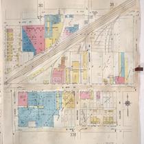
Title
-
Sanborn Map, Kansas City, Vol. 3, 1909-1950, Page p339
-
Description
-
A portion of Kansas City from E. 19th Street south to E. 21st Street and from College Avenue east to Bales Avenue, showing buildings, streets, and additions. Large numbers at edges of page refer to page with adjoining area.
-
Date
-
1909/1950
-
Object Type
-
Map
-

-
Title
-
Sanborn Map, Kansas City, Vol. 3, 1909-1950, Page p331
-
Description
-
A portion of Kansas City from E. 19th Street south to E. 21st Street and from Troost Avenue east to Tracy Avenue, showing buildings, streets and additions. Large numbers at edges of page refer to page with adjoining area.
-
Date
-
1909/1950
-
Object Type
-
Map
-
-
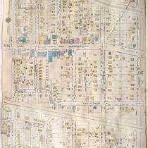
Title
-
Sanborn Map, Kansas City, Vol. 6, 1917-1957, Page p834
-
Description
-
A portion of the Intercity District connecting Kansas City, Missouri, and Independence, Missouri, from E. 15th Street south to E. 19th Street and from Maywood Avenue east to Northern Boulevard, showing buildings, streets, and additions. Large numbers at edges of page refer to page with adjoining area.
-
Date
-
1917/1957
-
Object Type
-
Map
-
-
Title
-
Sanborn Map, Kansas City, Vol. 6, 1917-1957, Page p842
-
Description
-
A portion of Independence, Missouri from Short Street south to W. South Avenue and from Claremont east to Forest Avenue, showing buildings, streets, and additions. Large numbers at edges of page refer to page with adjoining area.
-
Date
-
1917/1957
-
Object Type
-
Map
-
-
Title
-
Sanborn Map, Kansas City, Vol. 6, 1917-1957, Page p841
-
Description
-
A portion of Independence, Missouri, from Winner Road south to E. 20th Street and from Northern Boulevard east to Claremont, showing buildings, streets, and additions. Large numbers at edges of page refer to page with adjoining area.
-
Date
-
1917/1957
-
Object Type
-
Map
-
-
Title
-
Sanborn Map, Kansas City, Vol. 5, 1940-1941, Page p1236
-
Description
-
A portion of Kansas City from E. 18th Street south to E. 20th Street and from Bennington Avenue east to Winchester Avenue and a portion from E. 24th Street south to E. 27th Street and Lawndale Avenue east to Belmont Avenue, showing buildings and streets. Large numbers at edges of page refer to page with adjoining area. Indicated at top of sheet that this page number corresponds with pages 751 and 756 in Vol. 6.
-
Date
-
1940/1941
-
Object Type
-
Map
-

-
Title
-
Sanborn Map, Kansas City, Vol. 5, 1940-1941, Page p1209
-
Description
-
A portion of Kansas City from E. 15th Street south to E. 19th Street and from Oakley Avenue east to Belmont Avenue, showing buildings and streets. Large numbers at edges of page refer to page with adjoining area. Indicated at top of sheet that this page number corresponds with pages 718-720 in Vol. 5, 1909-1938.
-
Date
-
1940/1941
-
Object Type
-
Map
Pages
