Pages
-

-
Title
-
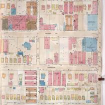
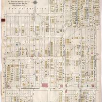
Sanborn Map, Kansas City, Vol. 1, 1909-1938, Page p095
-
Description
-
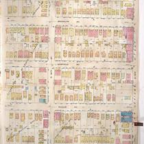
A portion of Kansas City from E. 30th Street south to E. 31st Street and from Southwest Boulevard east to Wyoming, showing buildings, streets, and additions. Large numbers at edges of page refer to page with adjoining area.
-
Date
-
1909/1938
-
Object Type
-
Map
-
-
Title
-
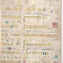
Sanborn Map, Kansas City, Vol. 3, 1909-1957, Page p398
-
Description
-
A portion of Kansas City from E. 30th Street south to E. 31st Street and from Campbell Street east to Forest Avenue, showing buildings, streets, and additions. Large numbers at edges of page refer to page with adjoining area.
-
Date
-
1909/1957
-
Object Type
-
Map
-
-
Title
-
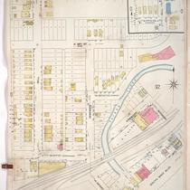
Sanborn Map, Kansas City, Vol. 3, 1909-1957, Page p414
-
Description
-
A portion of Kansas City from E. 30th Street south to E. 31st Street and from Indiana Avenue east to Cleveland Avenue, showing buildings, streets, and additions. Large numbers at edges of page refer to page with adjoining area.
-
Date
-
1909/1957
-
Object Type
-
Map
-
-
Title
-
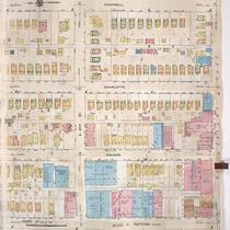
Sanborn Map, Kansas City, Vol. 3, 1909-1957, Page p396
-
Description
-
A portion of Kansas City from E. 30th Street south to E. 31st Street and from McGee Street Trafficway east to Campbell Street, showing buildings, streets, and additions. Large numbers at edges of page refer to page with adjoining area.
-
Date
-
1909/1957
-
Object Type
-
Map
-
-
Title
-
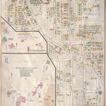
Sanborn Map, Kansas City, Vol. 1, 1909-1938, Page p091
-
Description
-
A portion of Kansas City from W. 27th Street south to E. 30th Street and from Bell east to Southwest Boulevard, showing buildings, streets, and additions. Large numbers at edges of page refer to page with adjoining area.
-
Date
-
1909/1938
-
Object Type
-
Map
-
-
Title
-
Sanborn Map, Kansas City, Vol. 6, 1917-1957, Page p753o
-
Description
-
A portion of Kansas City from E. 28th Street south to E. 31st Street and from Cleveland Avenue east to Kensington Avenue, showing buildings, streets, and additions. Large numbers at edges of page refer to page with adjoining area. At top of page, "All territory north of E. 31st St. not corrected since Nov. 1939. Now shown in Vol. 5." "Void" written in blue across page.
-
Date
-
1917/1957
-
Object Type
-
Map
-
-
Title
-
Sanborn Map, Kansas City, Vol. 6, 1917-1957, Page p755
-
Description
-
A portion of Kansas City from E. 27th Street south to Linwood Boulevard and from Lister Avenue east to Colorado Avenue, showing buildings, streets, and additions. Included are the McCune Parental Home for Boys, Hill Top School, and Jackson County Parental Home for Girls located near Independence, Missouri. Large numbers at edges of page refer to page with adjoining area. At top of page, "This sheet, except detachments, not corrected since Nov. 1939. Now shown in Vol. 5."
-
Date
-
1917/1957
-
Object Type
-
Map
-
-
Title
-
Sanborn Map, Kansas City, Vol. 5, 1940-1941, Page p1238
-
Description
-
A portion of Kansas City from E. 29th Street south to E. 31st Street and from Spruce Avenue east to York Avenue, showing buildings and streets. Large numbers at edges of page refer to page with adjoining area. Indicated at top of sheet that this page number corresponds with pages 753 and 754 in Vol. 6.
-
Date
-
1940/1941
-
Object Type
-
Map
-

-
Title
-
Sanborn Map, Kansas City, Vol. 5, 1940-1941, Page p1218
-
Description
-
A portion of Kansas City from E. 28th Street south to E. 31st Street and from Cleveland Avenue east to Wenzel Avenue, showing buildings and streets. Large numbers at edges of page refer to page with adjoining area. Indicated at top of sheet that this page number corresponds with page 685 in Vol. 5, 1909-1938 and page 753 in Vol. 6.
-
Date
-
1940/1941
-
Object Type
-
Map
-
-
Title
-
Sanborn Map, Kansas City, Vol. 5, 1940-1941, Page p1240
-
Description
-
A portion of Kansas City from E. 29th Street south to E. 31st Street and from York Avenue east to Oakley Avenue, showing buildings and streets. Large numbers at edges of page refer to page with adjoining area. Indicated at top of sheet that this page number corresponds with pages 754-756 in Vol. 6.
-
Date
-
1940/1941
-
Object Type
-
Map
-
-
Title
-
Sanborn Map, Kansas City, Vol. 3, 1909-1957, Page p391
-
Description
-
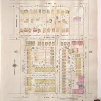
A portion of Kansas City from E. 29th Street south to E. 30th Street and from Main Street east to McGee Street, showing buildings, streets, and additions. Large numbers at edges of page refer to page with adjoining area.
-
Date
-
1909/1957
-
Object Type
-
Map
-
-
Title
-
Sanborn Map, Kansas City, Vol. 3, 1909-1957, Page p400
-
Description
-
A portion of Kansas City from E. 30th Street south to E. 31st Street and from Forest Avenue east to Flora Avenue, showing buildings, streets, and additions. Large numbers at edges of page refer to page with adjoining area.
-
Date
-
1909/1957
-
Object Type
-
Map
-
-
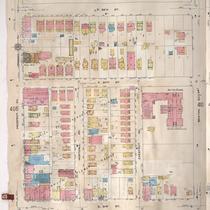
Title
-
Sanborn Map, Kansas City, Vol. 3, 1909-1957, Page p409
-
Description
-
A portion of Kansas City from E. 29th Street south to E. 31st Street and from Prospect Avenue east to Benton Boulevard, showing buildings, streets, and additions. Large numbers at edges of page refer to page with adjoining area.
-
Date
-
1909/1957
-
Object Type
-
Map
-
-
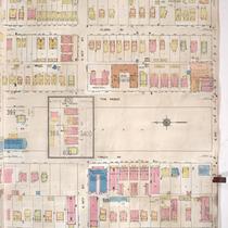
Title
-
Sanborn Map, Kansas City, Vol. 3, 1909-1957, Page p406
-
Description
-
A portion of Kansas City from E. 30th Street south to E. 31st Street and from Park Avenue east to Prospect Avenue, showing buildings, streets, and additions. Large numbers at edges of page refer to page with adjoining area.
-
Date
-
1909/1957
-
Object Type
-
Map
-
-
Title
-
Sanborn Map, Kansas City, Vol. 3, 1909-1957, Page p404
-
Description
-
A portion of Kansas City from E. 30th Street south to E. 31st and from Michigan Avenue east to Brooklyn Avenue, showing buildings, streets, and additions. Large numbers at edges of page refer to page with adjoining area.
-
Date
-
1909/1957
-
Object Type
-
Map
-

-
Title
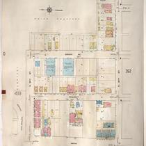
-
Sanborn Map, Kansas City, Vol. 3, 1909-1957, Page p392
-
Description
-
A portion of Kansas City from E. 30th Street south to E. 31st Street and from Main Street east to McGee Street, showing buildings, streets, and additions. Large numbers at edges of page refer to page with adjoining area.
-
Date
-
1909/1957
-
Object Type
-
Map
-

-
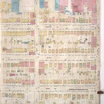
Title
-
Sanborn Map, Kansas City, Vol. 3, 1909-1957, Page p410
-
Description
-
A portion of Kansas City from E. 29th Street south to E. 31st Street and from Benton Boulevard east to Walrond Avenue, showing buildings, streets, and additions. Large numbers at edges of page refer to page with adjoining area.
-
Date
-
1909/1957
-
Object Type
-
Map
-
-
Title
-
Sanborn Map, Kansas City, Vol. 3, 1909-1957, Page p412
-
Description
-
A portion of Kansas City from E. 29th Street south to E. 31st Street and from Walrond Avenue east to Indiana Avenue, showing buildings, streets, and additions. Large numbers at edges of page refer to page with adjoining area.
-
Date
-
1909/1957
-
Object Type
-
Map
-

-
Title
-
Sanborn Map, Kansas City, Vol. 3, 1909-1957, Page p402
-
Description
-
A portion of Kansas City from E. 30th Street south to E. 31st Street and from Wayne Avenue east to Michigan Avenue, showing buildings, streets, and additions. Large numbers at edges of page refer to page with adjoining area.
-
Date
-
1909/1957
-
Object Type
-
Map
-

-
Title
-
Sanborn Map, Kansas City, Vol. 5, 1940-1941, Page p1241
-
Description
-
A portion of Kansas City from E. 27th Street south to E. 31st Street and from Oakley Avenue east to Belmont Avenue, showing buildings and streets. Large numbers at edges of page refer to page with adjoining area. Indicated at top of sheet that this page number corresponds with page 726 in Vol. 6.
-
Date
-
1940/1941
-
Object Type
-
Map
Pages
