Pages
-

-
Title
-
Sanborn Map, Kansas City, Vol. 5, 1909-1938, Page p706
-
Description
-
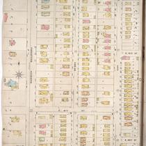
A portion of Kansas City from E. 38th Street south to E. 40th Street and from Fremont Avenue east to Bennington Avenue, showing buildings, streets, railroads, and additions. Large numbers at edges of page refer to page with adjoining area.
-
Date
-
1909/1938
-
Object Type
-
Map
-

-
Title
-
Sanborn Map, Kansas City, Vol. 4, 1909-1950, Page p537
-
Description
-
A portion of Kansas City from E. 39th Street south to E. 40th Street and from Flora Avenue east to Michigan Avenue, showing buildings, streets, and additions. Large numbers at edges of page refer to page with adjoining area.
-
Date
-
1909/1950
-
Object Type
-
Map
-
-
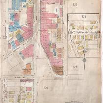
Title
-
Sanborn Map, Kansas City, Vol. 4, 1909-1950, Page p527
-
Description
-
A portion of Kansas City from E. 39th Street south to E. 40th Street and from Walnut Street east to Locust Street, showing buildings, streets, and additions. Large numbers at edges of page refer to page with adjoining area.
-
Date
-
1909/1950
-
Object Type
-
Map
-
-
Title
-
Sanborn Map, Kansas City, Vol. 6, 1917-1957, Page p763
-
Description
-
A portion of northeastern Kansas City from E. 39th Street south to about E. 41st Street and from Michigan Avenue east to Brooklyn Avenue, showing buildings, streets, and additions. Large numbers at edges of page refer to page with adjoining area.
-
Date
-
1917/1957
-
Object Type
-
Map
-

-
Title
-
Sanborn Map, Kansas City, Vol. 6, 1917-1957, Page p769
-
Description
-
A portion of northeastern Kansas City from E. 39th Street south to about E. 41st Street and from Chestnut Avenue east to Bellefontaine Avenue, showing buildings, streets, and additions. Large numbers at edges of page refer to page with adjoining area.
-
Date
-
1917/1957
-
Object Type
-
Map
-

-
Title
-
Sanborn Map, Kansas City, Vol. 6, 1917-1957, Page p860
-
Description
-
A portion of Leeds, Missouri, from E. 37th Street south to E. 40th Street and from Bennington Avenue east to Raytown Road, showing buildings, streets, and additions. Large numbers at edges of page refer to page with adjoining area. Noted at top of map, "(705-706-707-724-Vol. 5) Add'l Sheet, Nov. 1939."
-
Date
-
1917/1957
-
Object Type
-
Map
-
-
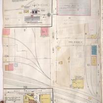
Title
-
Sanborn Map, Kansas City, Vol. 6, 1917-1957, Page p859
-
Description
-
A portion of Leeds, Missouri, from E. 37th Street south to E. 40th Street and from Belmont Avenue east to Bennington Avenue, showing buildings, streets, and additions. Large numbers at edges of page refer to page with adjoining area. Noted at top of map, "(705-706-722-Vol. 5) Add'l Sheet, Nov. 1939."
-
Date
-
1917/1957
-
Object Type
-
Map
-
-
Title
-
Sanborn Map, Kansas City, Vol. 5, 1909-1938, Page p707
-
Description
-
A portion of Kansas City at the intersection of E. 39th Street and Ewing Avenue, showing buildings, streets, railroads, and additions. Large numbers at edges of page refer to page with adjoining area.
-
Date
-
1909/1938
-
Object Type
-
Map
-

-
Title
-
Sanborn Map, Kansas City, Vol. 6, 1917-1957, Page p765
-
Description
-
A portion of northeastern Kansas City from E. 39th Street south to about E. 41st Street and from Brooklyn Avenue east to Wabash Avenue, showing buildings, streets, and additions. Large numbers at edges of page refer to page with adjoining area.
-
Date
-
1917/1957
-
Object Type
-
Map
-

-
Title
-
Sanborn Map, Kansas City, Vol. 6, 1917-1957, Page p767
-
Description
-
A portion of northeastern Kansas City from E. 39th Street south to about E. 41st Street and from Wabash Avenue east to Chestnut Avenue, showing buildings, streets, and additions. Large numbers at edges of page refer to page with adjoining area.
-
Date
-
1917/1957
-
Object Type
-
Map
-

-
Title
-
Sanborn Map, Kansas City, Vol. 6, 1917-1957, Page p829
-
Description
-
A portion of Kansas City from E. 40th Street south to E. 41st Street and from Bellefontaine Avenue east to Indiana Avenue, showing buildings, streets, and additions. Large numbers at edges of page refer to page with adjoining area. Noted at top of page, "New Sheet Dec. 1931."
-
Date
-
1917/1957
-
Object Type
-
Map
-
-
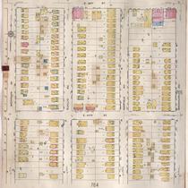
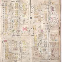
Title
-
Sanborn Map, Kansas City, Vol. 4, 1909-1950, Page p526
-
Description
-
A portion of Kansas City from E. 39th Street south to E. 40th Street and from Baltimore Avenue east to Walnut Street, showing buildings, streets, and additions. Large numbers at edges of page refer to page with adjoining area.
-
Date
-
1909/1950
-
Object Type
-
Map
-

-
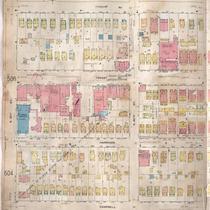
Title
-
Sanborn Map, Kansas City, Vol. 4, 1909-1950, Page p529
-
Description
-
A portion of Kansas City from E. 40th Street south to E. 41st Street and from Main Street east to Oak Street, showing buildings, streets, and additions. Large numbers at edges of page refer to page with adjoining area.
-
Date
-
1909/1950
-
Object Type
-
Map
-
-
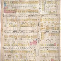
Title
-
Sanborn Map, Kansas City, Vol. 4, 1909-1950, Page p528
-
Description
-
A portion of Kansas City from E. 40th Street south to E. 43rd Street and from Oak Street east to Gillham Road, showing buildings, streets, and additions. Large numbers at edges of page refer to page with adjoining area.
-
Date
-
1909/1950
-
Object Type
-
Map
-

-
Title
-
Sanborn Map, Kansas City, Vol. 4, 1909-1950, Page p531
-
Description
-
A portion of Kansas City from E. 39th Street south to E. 40th Street and from Gillham Road east to Campbell Street, showing buildings, streets, and additions. Large numbers at edges of page refer to page with adjoining area.
-
Date
-
1909/1950
-
Object Type
-
Map
-
-
Title
-
Sanborn Map, Kansas City, Vol. 4, 1909-1950, Page p533
-
Description
-
A portion of Kansas City from E. 39th Street south to E. 40th Street and from Campbell Street east to Forest Avenue, showing buildings, streets and additions. Large numbers at edges of page refer to page with adjoining area.
-
Date
-
1909/1950
-
Object Type
-
Map
-
-
Title
-
Sanborn Map, Kansas City, Vol. 4, 1909-1950, Page p535
-
Description
-
A portion of Kansas City from E. 39th Street south to E. 40th Street and from Forest Avenue east to Flora Avenue, showing buildings, streets, and additions. Large numbers at edges of page refer to page with adjoining area.
-
Date
-
1909/1950
-
Object Type
-
Map
-

-
Title
-
Sanborn Map, Kansas City, Vol. 5, 1909-1938, Page p705
-
Description
-
A portion of Kansas City from E. 37th Street south to E. 38th Street and from Fremont Avenue east to Bennington Avenue, showing buildings, streets, and additions. Large numbers at edges of page refer to page with adjoining area.
-
Date
-
1909/1938
-
Object Type
-
Map
-
-
Title
-
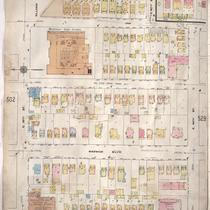
Sanborn Map, Kansas City, Vol. 1, 1895-1907, Page p093
-
Description
-
Southern part of early Kansas City on the outskirts of Westport from E. 40th Street south to E. 42nd Street and from Warwick Boulevard east to Oak Street, showing buildings, streets, and additions. Large numbers at edges of page refer to page with adjoining area.
-
Date
-
1895/1907
-
Object Type
-
Map
-
-
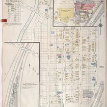
Title
-
Sanborn Map, Kansas City, Vol. 3, 1896-1907, Page p353
-
Description
-
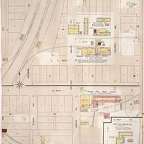
Southeastern part of early Kansas City in the Leeds Industrial district from E. 39th Street south to E. 40th Street, showing buildings, streets, railroad lines, and additions. Large numbers at edges of page refer to page with adjoining area.
-
Date
-
1896/1907
-
Object Type
-
Map
Pages
