Pages
-
-
Title
-
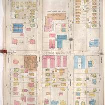
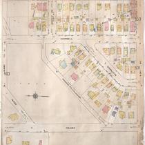
Sanborn Map, Kansas City, Vol. 4, 1909-1957, Page p479
-
Description
-
A portion of Kansas City from E. 34th Street south to E. 36th Street and from Locust east to Holmes Street, showing buildings, streets, and additions. Large numbers at edges of page refer to page with adjoining area.
-
Date
-
1909/1957
-
Object Type
-
Map
-

-
Title
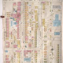
-
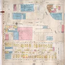
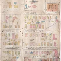
Sanborn Map, Kansas City, Vol. 3, 1909-1957, Page p393
-
Description
-
A portion of Kansas City from E. 28th Street south to McGee Street Trafficway and from Oak Street east to Cherry Street, showing buildings, streets, and additions. Large numbers at edges of page refer to page with adjoining area.
-
Date
-
1909/1957
-
Object Type
-
Map
-
-
Title
-
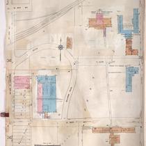
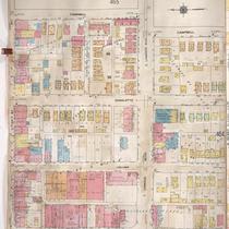
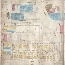
Sanborn Map, Kansas City, Vol. 4, 1909-1957, Page p461
-
Description
-
A portion of Kansas City from E. 31st Street south to E. Linwood Boulevard and from McGee east to Gillham Road, showing buildings, streets, and additions. Large numbers at edges of page refer to page with adjoining area.
-
Date
-
1909/1957
-
Object Type
-
Map
-
-
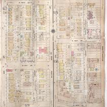
Title
-
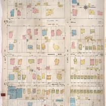
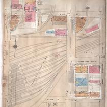
Sanborn Map, Kansas City, Vol. 3, 1909-1957, Page p343
-
Description
-
A portion of Kansas City from E. 21st Street south to E. 23rd Street and from McGee east to McCoy Avenue, showing buildings, streets, and additions. Large numbers at edges of page refer to page with adjoining area.
-
Date
-
1909/1957
-
Object Type
-
Map
-

-
Title
-
Sanborn Map, Kansas City, Vol. 4, 1909-1950, Page p463
-
Description
-
A portion of Kansas City from E. 31st Street south to E. Linwood Boulevard and from Gillham Road east to Campbell Street, showing buildings, streets, and additions. Large numbers at edges of page refer to page with adjoining area.
-
Date
-
1909/1950
-
Object Type
-
Map
-

-
Title
-
Sanborn Map, Kansas City, Vol. 4, 1909-1950, Page p540
-
Description
-
A portion of Kansas City from E. 44th Street south to E. 45th Street and from Kenwood Avenue east to Harrison Street, showing buildings, streets, and additions. Large numbers at edges of page refer to page with adjoining area.
-
Date
-
1909/1950
-
Object Type
-
Map
-
-
Title
-
Sanborn Map, Kansas City, Vol. 4, 1909-1950, Page p527
-
Description
-
A portion of Kansas City from E. 39th Street south to E. 40th Street and from Walnut Street east to Locust Street, showing buildings, streets, and additions. Large numbers at edges of page refer to page with adjoining area.
-
Date
-
1909/1950
-
Object Type
-
Map
-

-
Title
-
Sanborn Map, Kansas City, Vol. 3, 1909-1950, Page p343
-
Description
-
A portion of Kansas City from E. 21st Street south to E. 23rd Street and from McGee east to McCoy Avenue, showing buildings, streets, and additions. Large numbers at edges of page refer to page with adjoining area.
-
Date
-
1909/1950
-
Object Type
-
Map
-
-
Title
-
Sanborn Map, Kansas City, Vol. 4, 1909-1950, Page p504
-
Description
-
A portion of Kansas City from Gleed Terrace south to E. 39th Street and from Holmes Street east to Harrison Boulevard, showing buildings, streets. and additions. Large numbers at edges of page refer to page with adjoining area.
-
Date
-
1909/1950
-
Object Type
-
Map
-
-
Title
-
Sanborn Map, Kansas City, Vol. 4, 1909-1950, Page p502
-
Description
-
A portion of Kansas City from E. 38th Street south to E. 39th Street and from Main Street east to Locust Street, showing buildings, streets, and additions. Large numbers at edges of page refer to page with adjoining area.
-
Date
-
1909/1950
-
Object Type
-
Map
-

-
Title
-
Sanborn Map, Kansas City, Vol. 4, 1909-1950, Page p546
-
Description
-
A portion of Kansas City from E. 45th Street south to E. 47th Street and from Campbell Street east to Forest Avenue, showing buildings, streets, and additions. Large numbers at edges of page refer to page with adjoining area.
-
Date
-
1909/1950
-
Object Type
-
Map
-
-
Title
-
Sanborn Map, Kansas City, Vol. 4, 1909-1957, Page p463
-
Description
-
A portion of Kansas City from E. 31st Street south to E. Linwood Boulevard and from Gillham Road east to Campbell Street, showing buildings, streets, and additions. Large numbers at edges of page refer to page with adjoining area.
-
Date
-
1909/1957
-
Object Type
-
Map
-
-
Title
-
Sanborn Map, Kansas City, Vol. 4, 1909-1957, Page p501
-
Description
-
A portion of Kansas City from W. 36th Street south to W. 37th Street and from Main Street east to Locust Street, showing buildings, streets, and additions. Large numbers at edges of page refer to page with adjoining area.
-
Date
-
1909/1957
-
Object Type
-
Map
-
-
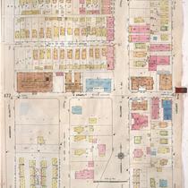
Title
-
Sanborn Map, Kansas City, Vol. 3, 1909-1950, Page p341
-
Description
-
A portion of Kansas City from E. 21st Street south to E. 23rd Street and from Main Street east to McGee, showing buildings, streets, and additions. Large numbers at edges of page refer to page with adjoining area.
-
Date
-
1909/1950
-
Object Type
-
Map
-
-
Title
-
Sanborn Map, Kansas City, Vol. 3, 1909-1957, Page p371
-
Description
-
A portion of Kansas City from E. 25th Street south to E. 26th Street and from Gillham Road east to Campbell Street, showing buildings, streets, and additions. Large numbers at edges of page refer to page with adjoining area.
-
Date
-
1909/1957
-
Object Type
-
Map
-
-
Title
-
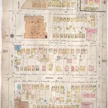
Sanborn Map, Kansas City, Vol. 4, 1909-1957, Page p478
-
Description
-
A portion of Kansas City from E. 34th Street south to E. 36th Street and from Warwick Boulevard east to Locust, showing buildings, streets, and additions. Large numbers at edges of page refer to page with adjoining area.
-
Date
-
1909/1957
-
Object Type
-
Map
-
-
Title
-
Sanborn Map, Kansas City, Vol. 4, 1909-1950, Page p528
-
Description
-
A portion of Kansas City from E. 40th Street south to E. 43rd Street and from Oak Street east to Gillham Road, showing buildings, streets, and additions. Large numbers at edges of page refer to page with adjoining area.
-
Date
-
1909/1950
-
Object Type
-
Map
-

-
Title
-
Sanborn Map, Kansas City, Vol. 4, 1909-1950, Page p531
-
Description
-
A portion of Kansas City from E. 39th Street south to E. 40th Street and from Gillham Road east to Campbell Street, showing buildings, streets, and additions. Large numbers at edges of page refer to page with adjoining area.
-
Date
-
1909/1950
-
Object Type
-
Map
-
-
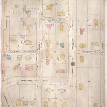
Title
-
Sanborn Map, Kansas City, Vol. 4, 1909-1950, Page p461
-
Description
-
A portion of Kansas City from E. 31st Street south to E. Linwood Boulevard and from McGee Street east to Gillham Road, showing buildings, streets, and additions. Large numbers at edges of page refer to page with adjoining area.
-
Date
-
1909/1950
-
Object Type
-
Map
-
-
Title
-
Sanborn Map, Kansas City, Vol. 4, 1909-1950, Page p545
-
Description
-
A portion of Kansas City from E. 45th Street south to E. 47th Street and from Kenwood Avenue east to Campbell Street, showing buildings, streets, and additions. Large numbers at edges of page refer to page with adjoining area.
-
Date
-
1909/1950
-
Object Type
-
Map
Pages
