Pages
-

-
Title
-
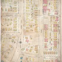
Sanborn Map, Kansas City, Vol. 4, 1909-1957, Page p495
-
Description
-
A portion of Kansas City from Valentine Road south to W. 38th Street and from Belleview Avenue east to Jefferson, showing buildings, streets, and additions. Large numbers at edges of page refer to page with adjoining area.
-
Date
-
1909/1957
-
Object Type
-
Map
-
-
Title
-
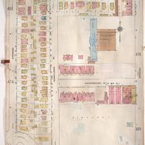
Sanborn Map, Kansas City, Vol. 4, 1909-1957, Page p475
-
Description
-
A portion of Kansas City from W. 35th Street south to Valentine Road and from Jefferson Street east to Broadway, showing buildings, streets, and additions. Large numbers at edges of page refer to page with adjoining area.
-
Date
-
1909/1957
-
Object Type
-
Map
-

-
Title
-
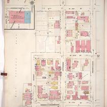
Sanborn Map, Kansas City, Vol. 4, 1909-1957, Page p474
-
Description
-
A portion of Kansas City from W. 36th Street south to Valentine Road and from Belleview Avenue east to Jefferson Street, showing buildings, streets, and additions. Large numbers at edges of page refer to page with adjoining area.
-
Date
-
1909/1957
-
Object Type
-
Map
-

-
Title
-
Sanborn Map, Kansas City, Vol. 1, 1909-1938, Page p058
-
Description
-
A portion of Kansas City from W. 18th Street south to W. 20th Street and from Belleview Avenue east to Jefferson Street, showing buildings, streets, and additions. Large numbers at edges of page refer to page with adjoining area.
-
Date
-
1909/1938
-
Object Type
-
Map
-
-
Title
-
Sanborn Map, Kansas City, Vol. 1, 1909-1938, Page p031
-
Description
-
A portion of Kansas City from W. 9th Street south to W. 11th Street and from Summit east to Pennsylvania Avenue, showing buildings, streets, and additions. Large numbers at edges of page refer to page with adjoining area.
-
Date
-
1909/1938
-
Object Type
-
Map
-

-
Title
-
Sanborn Map, Kansas City, Vol. 1, 1909-1938, Page p057
-
Description
-
A portion of Kansas City from W. 16th Street south to W. 17th Street and from Belleview Avenue east to Jefferson, showing buildings, streets, and additions. Large numbers at edges of page refer to page with adjoining area.
-
Date
-
1909/1938
-
Object Type
-
Map
-

-
Title
-
Sanborn Map, Kansas City, Vol. 4, 1909-1957, Page p453
-
Description
-
A portion of Kansas City from W. 31st Street south to W. 33rd Street and from Karnes Boulevard east to Pennsylvania Avenue, showing buildings, streets, and additions. Large numbers at edges of page refer to page with adjoining area.
-
Date
-
1909/1957
-
Object Type
-
Map
-

-
Title
-
Sanborn Map, Kansas City, Vol. 4, 1909-1950, Page p564
-
Description
-
A portion of Kansas City from W. 44th Street Terrace south to W. 46th Street and from Madison Avenue east to Pennsylvania Avenue, showing buildings, streets, and additions. Large numbers at edges of page refer to page with adjoining area.
-
Date
-
1909/1950
-
Object Type
-
Map
-
-
Title
-
Sanborn Map, Kansas City, Vol. 4, 1909-1950, Page p455
-
Description
-
A portion of Kansas City from W. 33rd Street south to W. 35th Street and from Coleman Road east to Jefferson Street, showing buildings, streets, and additions. Large numbers at edges of page refer to page with adjoining area.
-
Date
-
1909/1950
-
Object Type
-
Map
-

-
Title
-
Sanborn Map, Kansas City, Vol. 4, 1909-1950, Page p453
-
Description
-
A portion of Kansas City from W. 31st Street south to W. 33rd Street and from Karnes Boulevard east to Pennsylvania Avenue, showing buildings, streets, and additions. Large numbers at edges of page refer to page with adjoining area.
-
Date
-
1909/1950
-
Object Type
-
Map
-

-
Title
-
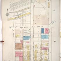
Sanborn Map, Kansas City, Vol. 1, 1909-1938, Page p082
-
Description
-
A portion of Kansas City from about W. 24th Street south to W. 25th Street and from Jefferson Street east to Broadway, showing buildings, streets, railroads, and additions. Large numbers at edges of page refer to page with adjoining area.
-
Date
-
1909/1938
-
Object Type
-
Map
-

-
Title
-
Sanborn Map, Kansas City, Vol. 1, 1909-1938, Page p071
-
Description
-
A portion of Kansas City from W. 20th Street south to W. Penn Way and from Madison Avenue east to Pennsylvania Avenue, showing buildings, streets, and additions. Large numbers at edges of page refer to page with adjoining area.
-
Date
-
1909/1938
-
Object Type
-
Map
-
-
Title
-
Sanborn Map, Kansas City, Vol. 1, 1909-1938, Page p081
-
Description
-
A portion of Kansas City from W. 25th Street south to W. 26th Street and from Madison Avenue east to Jefferson Street, showing buildings, streets, and additions. Large numbers at edges of page refer to page with adjoining area.
-
Date
-
1909/1938
-
Object Type
-
Map
-

-
Title
-
Sanborn Map, Kansas City, Vol. 9, 1930-1957, Page p1012
-
Description
-
A portion of Kansas City from W. 73rd Street south to W. 76th Street Terrace and from Jarboe Street east to Pennsylvania Avenue, showing buildings, streets, and additions. Large numbers at edges of page refer to page with adjoining area.
-
Date
-
1930/1957
-
Object Type
-
Map
-

-
Title
-
Sanborn Map, Kansas City, Vol. 1A, 1939-1949, Page p135
-
Description
-
A portion of Kansas City from W. 20th Street south to W. Pennway and from Madison Avenue east to Pennsylvania Avenue, showing buildings and streets. Large numbers at edges of page refer to page with adjoining area.
-
Date
-
1939/1949
-
Object Type
-
Map
-

-
Title
-
Sanborn Map, Kansas City, Vol. 9, 1930-1957, Page p1007
-
Description
-
A portion of Kansas City from Romany Road south to W. 73rd Street and from Ward Parkway east to Jefferson Street, showing buildings, streets, and additions. Large numbers at edges of page refer to page with adjoining area.
-
Date
-
1930/1957
-
Object Type
-
Map
-

-
Title
-
Sanborn Map, Kansas City, Vol. 9, 1930-1957, Page p1008
-
Description
-
A portion of Kansas City from W. 70th Street south to W. 73rd Street and from Jefferson Street east to Baltimore Avenue, showing buildings, streets, and additions. Large numbers at edges of page refer to page with adjoining area. Country Club Lumber Company is noted on the map, but the 1939 city directory calls it the Snyder-Kunkel Lumber Company, 321 W. Gregory Blvd.
-
Date
-
1930/1957
-
Object Type
-
Map
-

-
Title
-
Sanborn Map, Kansas City, Vol. 9, 1930-1941, Page p1015
-
Description
-
A portion of Kansas City from W. 75th Street south to W. 76th Street and from Jefferson Street east to Wornall Road, showing buildings, streets, and additions. Large numbers at edges of page refer to page with adjoining area.
-
Date
-
1930/1941
-
Object Type
-
Map
-

-
Title
-
Sanborn Map, Kansas City, Vol. 9, 1930-1941, Page p1001
-
Description
-
A portion of Kansas City from W. 63rd Street south to W. 66th Street Terrace and from Ward Parkway east to Pennsylvania Avenue, showing buildings, streets, and additions. Large numbers at edges of page refer to page with adjoining area.
-
Date
-
1930/1941
-
Object Type
-
Map
-

-
Title
-
Sanborn Map, Kansas City, Vol. 9, 1930-1941, Page p1012
-
Description
-
A portion of Kansas City from W. 73rd Street south to W. 76th Street Terrace and from Jarboe Street east to Pennsylvania Avenue, showing buildings, streets, and additions. Large numbers at edges of page refer to page with adjoining area.
-
Date
-
1930/1941
-
Object Type
-
Map
Pages
