Pages
-

-
Title
-
St. Luke's Episcopal Church
-
Description
-
Exterior view looking east along 4th street showing the original St. Luke's Episcopal Church (later renamed St. Mary's), once located on the northeast corner of 4th and Locust streets. The building was later occupied by St. Paul's Baptist Church.
-
Date
-
1892
-
Object Type
-
Photograph
-

-
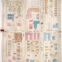
Title
-
Sanborn Map, Kansas City, Vol. 2, 1909-1937, Page p229
-
Description
-
A portion of Kansas City from E. 11th Street south to E. 13th Street and from Oak Street east to Cherry Street, showing buildings, streets, and additions. Large numbers at edges of page refer to page with adjoining area.
-
Date
-
1909/1937
-
Object Type
-
Map
-
-
Title
-
Sanborn Map, Kansas City, Vol. 4, 1909-1957, Page p479
-
Description
-
A portion of Kansas City from E. 34th Street south to E. 36th Street and from Locust east to Holmes Street, showing buildings, streets, and additions. Large numbers at edges of page refer to page with adjoining area.
-
Date
-
1909/1957
-
Object Type
-
Map
-
-
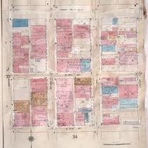
Title
-
Sanborn Map, Kansas City, Vol. 3, 1909-1957, Page p302
-
Description
-
A portion of Kansas City from Truman Road south to E. 17th Street and from Grand Avenue east to Locust, showing buildings, streets, and additions. Large numbers at edges of page refer to page with adjoining area.
-
Date
-
1909/1957
-
Object Type
-
Map
-

-
Title
-
Sanborn Map, Kansas City, Vol. 3, 1909-1957, Page p314
-
Description
-
A portion of Kansas City from E. 17th Street south to E. 19th Street and from Grand Avenue east to Locust, showing buildings, streets, and additions. Large numbers at edges of page refer to page with adjoining area.
-
Date
-
1909/1957
-
Object Type
-
Map
-

-
Title
-
Sanborn Map, Kansas City, Vol. 4, 1909-1950, Page p567
-
Description
-
A portion of Kansas City from E. 36th Street south to about E. 37th Street and from Locust east to Janssen Place, showing buildings, streets, and additions. Large numbers at edges of page refer to page with adjoining area. At top of map, "Add'l Sheet, May 1912."
-
Date
-
1909/1950
-
Object Type
-
Map
-

-
Title
-
Sanborn Map, Kansas City, Vol. 9, 1930-1957, Page p0937
-
Description
-
A portion of Kansas City from E. 61st Street south to E. 63rd Street and from Oak Street east to Kenwood Avenue, showing buildings, streets, and additions. Large numbers at edges of page refer to page with adjoining area.
-
Date
-
1930/1957
-
Object Type
-
Map
-
-
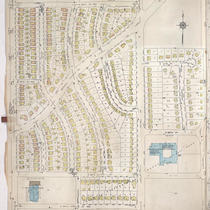
Title
-
Sanborn Map, Kansas City, Vol. 9, 1930-1957, Page p1019
-
Description
-
A portion of Kansas City from E. 66th Street Terrace south to E. 69th Street Terrace and from Oak Street east to Campbell Street, showing buildings, streets, and additions. Large numbers at edges of page refer to page with adjoining area. At top of map, "Add'l Sheet, June 1938."
-
Date
-
1930/1957
-
Object Type
-
Map
-

-
Title
-
Sanborn Map, Kansas City, Vol. 9, 1930-1941, Page p0937
-
Description
-
A portion of Kansas City from E. 61st Street south to E. 63rd Street and from Oak Street east to Kenwood Avenue, showing buildings, streets, and additions. Large numbers at edges of page refer to page with adjoining area.
-
Date
-
1930/1941
-
Object Type
-
Map
-

-
Title
-
Sanborn Map, Kansas City, Vol. 9, 1930-1957, Page p1024
-
Description
-
A portion of Kansas City from E. 73rd Street south to E. 76th Street Oak Street east to Charlotte Street, showing buildings, streets, and additions. Large numbers at edges of page refer to page with adjoining area.
-
Date
-
1930/1957
-
Object Type
-
Map
-

-
Title
-
Sanborn Map, Kansas City, Vol. 2, 1909-1937, Page p195
-
Description
-
A portion of Kansas City from Independence Avenue south to E. 8th Street and from Oak Street east to Cherry Street, showing buildings, streets and additions. Includes school district equipment storage buildings. Large numbers at edges of page refer to page with adjoining area.
-
Date
-
1909/1937
-
Object Type
-
Map
-

-
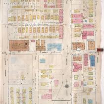
Title
-
Sanborn Map, Kansas City, Vol. 2, 1909-1937, Page p212
-
Description
-
A portion of Kansas City from E. 8th Street south to E. 11th Street and from Oak Street east to Holmes Street, showing buildings, streets, and additions. Large numbers at edges of page refer to page with adjoining area.
-
Date
-
1909/1937
-
Object Type
-
Map
-

-
Title
-
Sanborn Map, Kansas City, Vol. 4, 1909-1950, Page p502
-
Description
-
A portion of Kansas City from E. 38th Street south to E. 39th Street and from Main Street east to Locust Street, showing buildings, streets, and additions. Large numbers at edges of page refer to page with adjoining area.
-
Date
-
1909/1950
-
Object Type
-
Map
-

-
Title
-
Sanborn Map, Kansas City, Vol. 4, 1909-1957, Page p501
-
Description
-
A portion of Kansas City from W. 36th Street south to W. 37th Street and from Main Street east to Locust Street, showing buildings, streets, and additions. Large numbers at edges of page refer to page with adjoining area.
-
Date
-
1909/1957
-
Object Type
-
Map
-

-
Title
-
Sanborn Map, Kansas City, Vol. 3, 1909-1950, Page p329
-
Description
-
A portion of Kansas City from E. 19th Street south to E. 21st Street and from Locust east to Charlotte, showing buildings, streets, and additions. Large numbers at edges of page refer to page with adjoining area.
-
Date
-
1909/1950
-
Object Type
-
Map
-
-
Title
-
Sanborn Map, Kansas City, Vol. 4, 1909-1957, Page p478
-
Description
-
A portion of Kansas City from E. 34th Street south to E. 36th Street and from Warwick Boulevard east to Locust, showing buildings, streets, and additions. Large numbers at edges of page refer to page with adjoining area.
-
Date
-
1909/1957
-
Object Type
-
Map
-

-
Title
-
Sanborn Map, Kansas City, Vol. 4, 1909-1950, Page p528
-
Description
-
A portion of Kansas City from E. 40th Street south to E. 43rd Street and from Oak Street east to Gillham Road, showing buildings, streets, and additions. Large numbers at edges of page refer to page with adjoining area.
-
Date
-
1909/1950
-
Object Type
-
Map
-
-
Title
-
Sanborn Map, Kansas City, Vol. 3, 1909-1950, Page p314
-
Description
-
A portion of Kansas City from E. 17th Street south to E. 19th Street and from Grand Avenue east to Locust, showing buildings, streets, and additions. Large numbers at edges of page refer to page with adjoining area.
-
Date
-
1909/1950
-
Object Type
-
Map
-

-
Title
-
Sanborn Map, Kansas City, Vol. 3, 1909-1950, Page p315
-
Description
-
A portion of Kansas City from E. 17th Street south to E. 19th Street and from Locust east to Charlotte, showing buildings, streets and additions. Large numbers at edges of page refer to page with adjoining area.
-
Date
-
1909/1950
-
Object Type
-
Map
Pages

