-
-
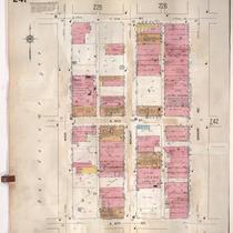
Title
-
Sanborn Map, Kansas City, Vol. 2, 1909-1937, Page p241
-
Description
-
A portion of Kansas City from E. 13th Street south to E. 15th Street and from Main Street east to Grand Avenue, showing buildings, streets, and additions. Large numbers at edges of page refer to page with adjoining area.
-
Date
-
1909/1937
-
Object Type
-
Map
-

-
Title
-
Sanborn Map, Kansas City, Vol. 2, 1909-1937, Page p157
-
Description
-
A portion of Kansas City Old Town from E. 3rd Street south to E. Missouri Avenue and from Main Street east to Walnut, showing buildings, streets and additions. Large numbers at edges of page refer to page with adjoining area.
-
Date
-
1909/1937
-
Object Type
-
Map
-

-
Title
-
Sanborn Map, Kansas City, Vol. 2, 1909-1937, Page p207
-
Description
-
A portion of Kansas City from E. 7th Street south to E. 9th Street and from Main Street east to Walnut Street, showing buildings, streets, and additions. Large numbers at edges of page refer to page with adjoining area.
-
Date
-
1909/1937
-
Object Type
-
Map
-

-
Title
-
Sanborn Map, Kansas City, Vol. 2, 1909-1937, Page p193
-
Description
-
A portion of Kansas City from E. Missouri Avenue south to E. 7th Street and from Main Street east to Walnut, showing buildings, streets, and additions. Large numbers at edges of page refer to page with adjoining area.
-
Date
-
1909/1937
-
Object Type
-
Map
-

-
Title
-
Sanborn Map, Kansas City, Vol. 2, 1909-1937, Page p151
-
Description
-
A portion of Kansas City Old Town from E. 1st Street south to E. 3rd Street and from Main Street east to Grand Avenue, showing buildings, streets, railroads, and additions. Large numbers at edges of page refer to page with adjoining area. Volume begins with sheet 151.
-
Date
-
1909/1937
-
Object Type
-
Map
