-

-
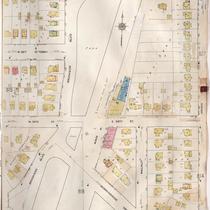
Title
-
Sanborn Map, Kansas City, Vol. 6, 1917-1957, Page p812
-
Description
-
A portion of Kansas City from E. 55th Street south to E. 57th Street and from Main Street east to Brookside Boulevard, showing buildings, streets, and additions. Large numbers at edges of page refer to page with adjoining area.
-
Date
-
1917/1957
-
Object Type
-
Map
-
-
Title
-
Sanborn Map, Kansas City, Vol. 6, 1917-1957, Page p816
-
Description
-
A portion of Kansas City from W. 58th Street south to Morningside Drive and from Brookside Boulevard east to Grand Avenue, showing buildings, streets, and additions. Large numbers at edges of page refer to page with adjoining area.
-
Date
-
1917/1957
-
Object Type
-
Map
-

-
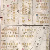
Title
-
Sanborn Map, Kansas City, Vol. 6, 1917-1957, Page p818
-
Description
-
A portion of Kansas City from Huntington Road south to W. 61st Street Terrace and from Brookside Boulevard east to Walnut Street, showing buildings, streets, and additions. Large numbers at edges of page refer to page with adjoining area.
-
Date
-
1917/1957
-
Object Type
-
Map
-

-
Title
-
Sanborn Map, Kansas City, Vol. 6, 1917-1957, Page p806
-
Description
-
A portion of western Kansas City from E. 51st Street south to E. 53rd Street and from Main Street east to Grand Avenue, showing buildings, streets, and additions. Large numbers at edges of page refer to page with adjoining area.
-
Date
-
1917/1957
-
Object Type
-
Map
-

-
Title
-
Sanborn Map, Kansas City, Vol. 6, 1917-1957, Page p810
-
Description
-
A portion of Kansas City from E. 53rd Street south to E. 54th Street Terrace and from Baltimore Avenue east to Westover Road, showing buildings, streets, and additions. Large numbers at edges of page refer to page with adjoining area.
-
Date
-
1917/1957
-
Object Type
-
Map
-

-
Title
-
Sanborn Map, Kansas City, Vol. 6, 1917-1957, Page p804
-
Description
-
A portion of western Kansas City from E. 50th Street south to E. 51st Street Terrace and from Baltimore Avenue east to Grand Avenue, showing buildings, streets, and additions. Large numbers at edges of page refer to page with adjoining area.
-
Date
-
1917/1957
-
Object Type
-
Map
-
-
Title
-
Sanborn Map, Kansas City, Vol. 6, 1917-1957, Page p813
-
Description
-
A portion of Kansas City from 57th Street south to 58th Street and from Wornall Road east to Brookside Boulevard, showing buildings, streets, and additions. Large numbers at edges of page refer to page with adjoining area.
-
Date
-
1917/1957
-
Object Type
-
Map
