Pages
-
-
Title
-
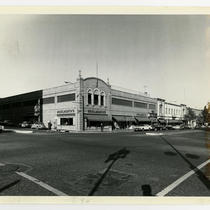
Woolworth's Country Club Plaza
-
Description
-
View looking northeast of the Woolworth's store and other buildings that once stood along the north side of Nichols Road from its intersection with Pennsylvania Avenue in the Country Club Plaza. Cars and pedestrians can be seen.
-
Date
-
1980-12
-
Object Type
-
Photograph
-

-
Title
-
Westport City Hall
-
Description
-
View looking east of the Westport City Hall building that once stood at the intersection of Pennsylvania Avenue and High (now W. 40th Terrace) Street. The building also served as stations for the fire and police departments. A car is parked along High Street.
-
Date
-
1929-11-02
-
Object Type
-
Photograph
-

-
Title
-
Woolworth's Country Club Plaza
-
Description
-
View looking north of the Woolworth's store that once stood along the north side of Nichols Road at its intersection with Pennsylvania Avenue in the Country Club Plaza. Cars and pedestrians can be seen.
-
Date
-
1980-10
-
Object Type
-
Photograph
-

-
Title
-
Penn School
-
Description
-
View of the Penn School, once located at 4237 Pennsylvania Avenue.
-
Object Type
-
Photograph
-
-
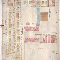
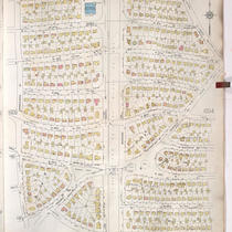
Title
-
Sanborn Map, Kansas City, Vol. 4, 1909-1957, Page p475
-
Description
-
A portion of Kansas City from W. 35th Street south to Valentine Road and from Jefferson Street east to Broadway, showing buildings, streets, and additions. Large numbers at edges of page refer to page with adjoining area.
-
Date
-
1909/1957
-
Object Type
-
Map
-

-
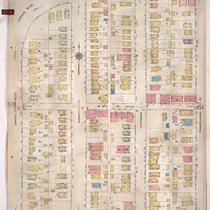
Title
-
Sanborn Map, Kansas City, Vol. 1, 1909-1938, Page p031
-
Description
-
A portion of Kansas City from W. 9th Street south to W. 11th Street and from Summit east to Pennsylvania Avenue, showing buildings, streets, and additions. Large numbers at edges of page refer to page with adjoining area.
-
Date
-
1909/1938
-
Object Type
-
Map
-

-
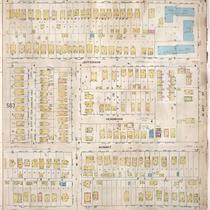
Title
-
Sanborn Map, Kansas City, Vol. 1, 1909-1938, Page p032
-
Description
-
A portion of Kansas City from W. 9th Street south to W. 11th Street and from Pennsylvania Avenue east to Broadway, showing buildings, streets, and additions. Large numbers at edges of page refer to page with adjoining area.
-
Date
-
1909/1938
-
Object Type
-
Map
-

-
Title
-
Sanborn Map, Kansas City, Vol. 1, 1909-1938, Page p099
-
Description
-
A portion of Kansas City from W. 29th Street south to Karnes Boulevard and from Madison Avenue east to Pennsylvania Avenue, showing buildings, streets, and additions. Large numbers at edges of page refer to page with adjoining area.
-
Date
-
1909/1938
-
Object Type
-
Map
-

-
Title
-
Sanborn Map, Kansas City, Vol. 1, 1909-1938, Page p073
-
Description
-
A portion of Kansas City from W. 20th Street south to Southwest Boulevard and from Pennsylvania Avenue east to Broadway, showing buildings, streets, and additions. Large numbers at edges of page refer to page with adjoining area.
-
Date
-
1909/1938
-
Object Type
-
Map
-
-
Title
-
Sanborn Map, Kansas City, Vol. 4, 1909-1957, Page p453
-
Description
-
A portion of Kansas City from W. 31st Street south to W. 33rd Street and from Karnes Boulevard east to Pennsylvania Avenue, showing buildings, streets, and additions. Large numbers at edges of page refer to page with adjoining area.
-
Date
-
1909/1957
-
Object Type
-
Map
-

-
Title
-
Sanborn Map, Kansas City, Vol. 4, 1909-1957, Page p498
-
Description
-
A portion of Kansas City from W. 38th Street south to W. 40th Street and from Pennsylvania Avenue east to Broadway, showing buildings, streets, and additions. Large numbers at edges of page refer to page with adjoining area.
-
Date
-
1909/1957
-
Object Type
-
Map
-
-
Title
-
Sanborn Map, Kansas City, Vol. 4, 1909-1950, Page p564
-
Description
-
A portion of Kansas City from W. 44th Street Terrace south to W. 46th Street and from Madison Avenue east to Pennsylvania Avenue, showing buildings, streets, and additions. Large numbers at edges of page refer to page with adjoining area.
-
Date
-
1909/1950
-
Object Type
-
Map
-

-
Title
-
Sanborn Map, Kansas City, Vol. 4, 1909-1950, Page p453
-
Description
-
A portion of Kansas City from W. 31st Street south to W. 33rd Street and from Karnes Boulevard east to Pennsylvania Avenue, showing buildings, streets, and additions. Large numbers at edges of page refer to page with adjoining area.
-
Date
-
1909/1950
-
Object Type
-
Map
-

-
Title
-
Sanborn Map, Kansas City, Vol. 1, 1909-1938, Page p071
-
Description
-
A portion of Kansas City from W. 20th Street south to W. Penn Way and from Madison Avenue east to Pennsylvania Avenue, showing buildings, streets, and additions. Large numbers at edges of page refer to page with adjoining area.
-
Date
-
1909/1938
-
Object Type
-
Map
-
-
Title
-
Sanborn Map, Kansas City, Vol. 9, 1930-1957, Page p1006
-
Description
-
A portion of Kansas City from W. 66th Street Terrace south to W. 70th Street and from Pennsylvania Avenue east to Linden Road, showing buildings, streets, and additions. Large numbers at edges of page refer to page with adjoining area.
-
Date
-
1930/1957
-
Object Type
-
Map
-

-
Title
-
Sanborn Map, Kansas City, Vol. 9, 1930-1957, Page p1013
-
Description
-
A portion of Kansas City from W. 73rd Street south to W. 75th Street and from Pennsylvania Avenue east to Wornall Road, showing buildings, streets, and additions. Large numbers at edges of page refer to page with adjoining area.
-
Date
-
1930/1957
-
Object Type
-
Map
-

-
Title
-
Sanborn Map, Kansas City, Vol. 9, 1930-1957, Page p1012
-
Description
-
A portion of Kansas City from W. 73rd Street south to W. 76th Street Terrace and from Jarboe Street east to Pennsylvania Avenue, showing buildings, streets, and additions. Large numbers at edges of page refer to page with adjoining area.
-
Date
-
1930/1957
-
Object Type
-
Map
-

-
Title
-
Sanborn Map, Kansas City, Vol. 9, 1930-1957, Page p1002
-
Description
-
A portion of Kansas City from W. 63rd Street south to W. 66th Street Terrace and from Pennsylvania Avenue east to Baltimore Avenue, showing buildings, streets, and additions. Large numbers at edges of page refer to page with adjoining area.
-
Date
-
1930/1957
-
Object Type
-
Map
-

-
Title
-
Sanborn Map, Kansas City, Vol. 9, 1930-1957, Page p1005
-
Description
-
A portion of Kansas City from W. 66th Street Terrace south to W. 70th Street and from Ward Parkway east to Pennsylvania Avenue, showing buildings, streets, and additions. Large numbers at edges of page refer to page with adjoining area.
-
Date
-
1930/1957
-
Object Type
-
Map
-

-
Title
-
Sanborn Map, Kansas City, Vol. 1A, 1939-1949, Page p135
-
Description
-
A portion of Kansas City from W. 20th Street south to W. Pennway and from Madison Avenue east to Pennsylvania Avenue, showing buildings and streets. Large numbers at edges of page refer to page with adjoining area.
-
Date
-
1939/1949
-
Object Type
-
Map
Pages
