Pages
-

-
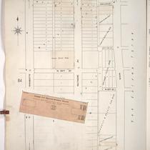
Title
-
Sanborn Map, Kansas City, Vol. 1, 1909-1938, Page p070
-
Description
-
A portion of Kansas City from W. 23rd Street Trafficway south to W. 25th Street and from Holly Street east to Madison Avenue, showing buildings, streets, and additions. Large numbers at edges of page refer to page with adjoining area.
-
Date
-
1909/1938
-
Object Type
-
Map
-

-
Title
-
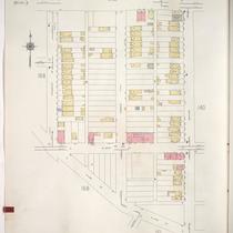
Sanborn Map, Kansas City, Vol. 1, 1909-1938, Page p082
-
Description
-
A portion of Kansas City from about W. 24th Street south to W. 25th Street and from Jefferson Street east to Broadway, showing buildings, streets, railroads, and additions. Large numbers at edges of page refer to page with adjoining area.
-
Date
-
1909/1938
-
Object Type
-
Map
-

-
Title
-
Sanborn Map, Kansas City, Vol. 1, 1909-1938, Page p085
-
Description
-
A portion of Kansas City from Esplanade south to W. 26th Street and from Wyandotte east to Main, showing buildings, streets, and additions. Large numbers at edges of page refer to page with adjoining area.
-
Date
-
1909/1938
-
Object Type
-
Map
-
-
Title
-
Sanborn Map, Kansas City, Vol. 1, 1909-1938, Page p085
-
Description
-
A portion of Kansas City from Esplanade south to W. 26th Street and from Wyandotte east to Main, showing buildings, streets, and additions. Large numbers at edges of page refer to page with adjoining area.
-
Date
-
1909/1938
-
Object Type
-
Map
-

-
Title
-
Sanborn Map, Kansas City, Vol. 1, 1909-1938, Page p081
-
Description
-
A portion of Kansas City from W. 25th Street south to W. 26th Street and from Madison Avenue east to Jefferson Street, showing buildings, streets, and additions. Large numbers at edges of page refer to page with adjoining area.
-
Date
-
1909/1938
-
Object Type
-
Map
-

-
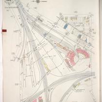
Title
-
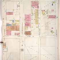
Sanborn Map, Kansas City, Vol. 1A, 1939-1949, Page p142
-
Description
-
A portion of Kansas City from W. 25th Street south to W. 26th Street and from Southwest Boulevard east to Madison Avenue, showing buildings, railroads, and streets. Large numbers at edges of page refer to page with adjoining area.
-
Date
-
1939/1949
-
Object Type
-
Map
-
-
Title
-
Sanborn Map, Kansas City, Vol. 1A, 1939-1949, Page p146
-
Description
-
A portion of Kansas City from W. 22nd Street south to W. 25th Street and from Broadway east to Main Street, showing buildings and streets. Large numbers at edges of page refer to page with adjoining area.
-
Date
-
1939/1949
-
Object Type
-
Map
-
-
Title
-
Sanborn Map, Kansas City, Vol. 1A, 1939-1949, Page p144
-
Description
-
A portion of Kansas City from W. 24th Street south to W. 25th Street and from Madison Avenue east to W. Pennway, showing buildings, railroads, and streets. Large numbers at edges of page refer to page with adjoining area.
-
Date
-
1939/1949
-
Object Type
-
Map
-

-
Title
-
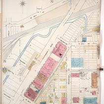
Sanborn Map, Kansas City, Vol. 1, 1909-1938, Page p068
-
Description
-
A portion of Kansas City from 23rd Street Trafficway south to W. 25th Street and from Fairmount Avenue east to Holly Street, showing buildings, streets, and additions. Large numbers at edges of page refer to page with adjoining area.
-
Date
-
1909/1938
-
Object Type
-
Map
-

-
Title
-
Sanborn Map, Kansas City, Vol. 1A, 1939-1949, Page p140
-
Description
-
A portion of Kansas City from W. 23rd Street Trafficway south to W. 25th Street and from Mercier Street east to Jarboe Street, showing buildings and streets. Large numbers at edges of page refer to page with adjoining area. Handwritten at the top of the page in red, "Poor Section."
-
Date
-
1939/1949
-
Object Type
-
Map
-
-
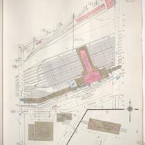
Title
-
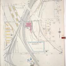
Sanborn Map, Kansas City, Vol. 1A, 1939-1949, Page p151
-
Description
-
A portion of Kansas City from W. 25th Street south to W. 27th Street and from Wyoming east to Jarboe, showing the Kansas City Terminal Railway Company yards, roundhouse and shops. Large numbers at edges of page refer to page with adjoining area.
-
Date
-
1939/1949
-
Object Type
-
Map
-

-
Title
-
Sanborn Map, Kansas City, Vol. 1A, 1939-1949, Page p145
-
Description
-
A portion of Kansas City from W. 24th Street south to W. 25th Street and from W. Pennway east to Broadway, showing buildings, railroads, and streets. Large numbers at edges of page refer to page with adjoining area.
-
Date
-
1939/1949
-
Object Type
-
Map
-
-
Title
-
Sanborn Map, Kansas City, Vol. 1A, 1939-1949, Page p148
-
Description
-
A portion of Kansas City from W. 25th Street south to W. 26th Street and from Madison Avenue east to W. Pennway, showing buildings and streets. Large numbers at edges of page refer to page with adjoining area.
-
Date
-
1939/1949
-
Object Type
-
Map
-
-
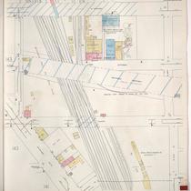
Title
-
Sanborn Map, Kansas City, Vol. 1A, 1939-1949, Page p168
-
Description
-
A portion of Kansas City from W. 21st Street south to W. 25th Street and from State Line east to Terrace Street, showing buildings, railroads, and streets. Large numbers at edges of page refer to page with adjoining area.
-
Date
-
1939/1949
-
Object Type
-
Map
-
-
Title
-
Sanborn Map, Kansas City, Vol. 1A, 1939-1949, Page p139
-
Description
-
A portion of Kansas City from W. 23rd Street Trafficway south to W. 25th Street and from Fairmount Street east to Mercier Street, showing buildings and streets. Large numbers at edges of page refer to page with adjoining area.
-
Date
-
1939/1949
-
Object Type
-
Map
-

-
Title
-
Sanborn Map, Kansas City, Vol. 1A, 1939-1949, Page p147
-
Description
-
A portion of Kansas City from W. 25th Street south to W. 26th Street and from W. Pennway east to Central Street, showing buildings and streets. Large numbers at edges of page refer to page with adjoining area.
-
Date
-
1939/1949
-
Object Type
-
Map
-
-
Title
-
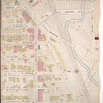
Sanborn Map, Kansas City, Vol. 1, 1909-1938, Page p083
-
Description
-
A portion of Kansas City from W. 25th Street south to W. 26th Street and from Jefferson east to Broadway, showing buildings, streets, and additions. Large numbers at edges of page refer to page with adjoining area.
-
Date
-
1909/1938
-
Object Type
-
Map
-

-
Title
-
Sanborn Map, Kansas City, Vol. 1A, 1939-1949, Page p141
-
Description
-
A portion of Kansas City from W. 23rd Street Trafficway south to W. 25th Street and from Jarboe Street east to Madison Avenue, showing buildings, railroads, and streets. Large numbers at edges of page refer to page with adjoining area.
-
Date
-
1939/1949
-
Object Type
-
Map
-
-
Title
-
Sanborn Map, Kansas City, Vol. 1, 1909-1938, Page p080
-
Description
-
A portion of Kansas City from W. 25th Street south to W. 26th Street and from Holly east to Madison Avenue, showing buildings, streets, and additions. Large numbers at edges of page refer to page with adjoining area.
-
Date
-
1909/1938
-
Object Type
-
Map
-
-
Title
-
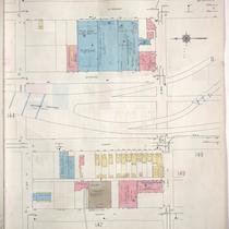
Sanborn Map, Kansas City, Vol. 1, 1895-1907, Page p054
-
Description
-
North central part of early Kansas City in the West Bottoms area from about W. 24th Street south to W. 25th Street and from Holly Street east to Madison Avenue, showing buildings, streets, and O. K. Creek. Large numbers at edges of page refer to page with adjoining area.
-
Date
-
1895/1907
-
Object Type
-
Map
Pages
