-

-
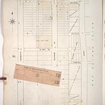
Title
-
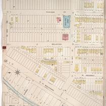
Sanborn Map, Kansas City, Vol. 1, 1909-1938, Page p085
-
Description
-
A portion of Kansas City from Esplanade south to W. 26th Street and from Wyandotte east to Main, showing buildings, streets, and additions. Large numbers at edges of page refer to page with adjoining area.
-
Date
-
1909/1938
-
Object Type
-
Map
-
-
Title
-
Sanborn Map, Kansas City, Vol. 1, 1909-1938, Page p081
-
Description
-
A portion of Kansas City from W. 25th Street south to W. 26th Street and from Madison Avenue east to Jefferson Street, showing buildings, streets, and additions. Large numbers at edges of page refer to page with adjoining area.
-
Date
-
1909/1938
-
Object Type
-
Map
-

-
Title
-
Sanborn Map, Kansas City, Vol. 1A, 1939-1949, Page p142
-
Description
-
A portion of Kansas City from W. 25th Street south to W. 26th Street and from Southwest Boulevard east to Madison Avenue, showing buildings, railroads, and streets. Large numbers at edges of page refer to page with adjoining area.
-
Date
-
1939/1949
-
Object Type
-
Map
-

-
Title
-
Sanborn Map, Kansas City, Vol. 1, 1909-1938, Page p086
-
Description
-
A portion of Kansas City from W. 26th Street south to W. 27th Street and from Central east to Main, showing buildings, streets, and additions. Large numbers at edges of page refer to page with adjoining area.
-
Date
-
1909/1938
-
Object Type
-
Map
-

-
Title
-
Sanborn Map, Kansas City, Vol. 1, 1909-1938, Page p090
-
Description
-
A portion of Kansas City from W. 26th Street south to W. 27th Street and from Jarboe east to Summit, showing buildings, streets, and additions. Large numbers at edges of page refer to page with adjoining area.
-
Date
-
1909/1938
-
Object Type
-
Map
-

-
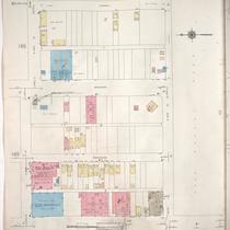
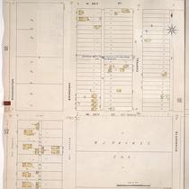
Title
-
Sanborn Map, Kansas City, Vol. 1A, 1939-1949, Page p149
-
Description
-
A portion of Kansas City from W. 26th Street south to W. 27th Street and from Jarboe Street east to Summit Street, showing buildings and streets. Large numbers at edges of page refer to page with adjoining area. Handwritten at top of page in red, "Negro Section."
-
Date
-
1939/1949
-
Object Type
-
Map
-
-
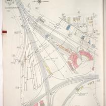
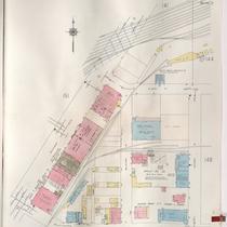
Title
-
Sanborn Map, Kansas City, Vol. 1A, 1939-1949, Page p151
-
Description
-
A portion of Kansas City from W. 25th Street south to W. 27th Street and from Wyoming east to Jarboe, showing the Kansas City Terminal Railway Company yards, roundhouse and shops. Large numbers at edges of page refer to page with adjoining area.
-
Date
-
1939/1949
-
Object Type
-
Map
-

-
Title
-
Sanborn Map, Kansas City, Vol. 1A, 1939-1949, Page p148
-
Description
-
A portion of Kansas City from W. 25th Street south to W. 26th Street and from Madison Avenue east to W. Pennway, showing buildings and streets. Large numbers at edges of page refer to page with adjoining area.
-
Date
-
1939/1949
-
Object Type
-
Map
-
-
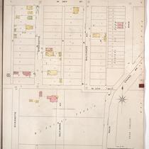
Title
-
Sanborn Map, Kansas City, Vol. 1A, 1939-1949, Page p147
-
Description
-
A portion of Kansas City from W. 25th Street south to W. 26th Street and from W. Pennway east to Central Street, showing buildings and streets. Large numbers at edges of page refer to page with adjoining area.
-
Date
-
1939/1949
-
Object Type
-
Map
-

-
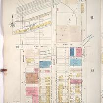
Title
-
Sanborn Map, Kansas City, Vol. 1, 1909-1938, Page p083
-
Description
-
A portion of Kansas City from W. 25th Street south to W. 26th Street and from Jefferson east to Broadway, showing buildings, streets, and additions. Large numbers at edges of page refer to page with adjoining area.
-
Date
-
1909/1938
-
Object Type
-
Map
-

-
Title
-
Sanborn Map, Kansas City, Vol. 1, 1909-1938, Page p080
-
Description
-
A portion of Kansas City from W. 25th Street south to W. 26th Street and from Holly east to Madison Avenue, showing buildings, streets, and additions. Large numbers at edges of page refer to page with adjoining area.
-
Date
-
1909/1938
-
Object Type
-
Map
-

-
Title
-
Sanborn Map, Kansas City, Vol. 1, 1895-1907, Page p063
-
Description
-
Central part of early Kansas City from about W. 24th Street south to W. 26th Street and from Washington Street east to Central Street, showing buildings, streets, and additions. Large numbers at edges of page refer to page with adjoining area.
-
Date
-
1895/1907
-
Object Type
-
Map
-

-
Title
-
Sanborn Map, Kansas City, Vol. 1, 1895-1907, Page p064
-
Description
-
Central part of early Kansas City in the Union Hill area from about W. 24th Street south to W. 26th Street and from Wyandotte Street east to Main Street, showing buildings, streets, and additions. Large numbers at edges of page refer to page with adjoining area.
-
Date
-
1895/1907
-
Object Type
-
Map
-
-
Title
-
Sanborn Map, Kansas City, Vol. 1, 1895-1907, Page p059
-
Description
-
Central part of early Kansas City from W. 25th Street south to W. 26th Street and from Holly Street east to Madision Avenue, showing buildings, streets, and Turkey Creek. Large numbers on edges of page refer to page with adjoining area.
-
Date
-
1895/1907
-
Object Type
-
Map
-
-
Title
-
Sanborn Map, Kansas City, Vol. 1, 1895-1907, Page p065
-
Description
-
Penn Valley Park area of early Kansas City from W. 26th Street south to W. 27th Street and from Washington Street east to Wyandotte Street, showing buildings, streets, and additions. Large numbers at edges of page refer to page with adjoining area.
-
Date
-
1895/1907
-
Object Type
-
Map
-

-
Title
-
Sanborn Map, Kansas City, Vol. 1A, 1939-1957, Page p149
-
Description
-
A portion of Kansas City from W. 26th Street south to W. 27th Street and from Jarboe Street east to Summit Street, showing buildings and streets. Large numbers at edges of page refer to page with adjoining area.
-
Date
-
1939/1957
-
Object Type
-
Map
-
-
Title
-
Sanborn Map, Kansas City, Vol. 1A, 1939-1957, Page p142
-
Description
-
A portion of Kansas City from W. 25th Street south to W. 26th Street and from Southwest Boulevard east to Madison Avenue, showing buildings, railroads, and streets. Large numbers at edges of page refer to page with adjoining area.
-
Date
-
1939/1957
-
Object Type
-
Map
-
-
Title
-
Sanborn Map, Kansas City, Vol. 1, 1895-1907, Page p066
-
Description
-
Central part of early Kansas City in the Union Hill area from W. 26th Street south to W. 27th Street and from Wyandotte Street east to the edge of Union Cemetery, showing buildings, streets, and additions. Large numbers at edges of page refer to page with adjoining area.
-
Date
-
1895/1907
-
Object Type
-
Map
-

-
Title
-
Sanborn Map, Kansas City, Vol. 1A, 1939-1957, Page p148
-
Description
-
A portion of Kansas City from W. 25th Street south to W. 26th Street and from Madison Avenue east to W. Pennway, showing buildings and streets. Large numbers at edges of page refer to page with adjoining area.
-
Date
-
1939/1957
-
Object Type
-
Map
