Pages
-

-
Title
-
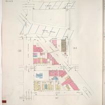
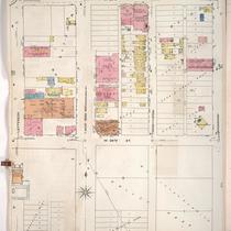
Sanborn Map, Kansas City, Vol. 1, 1909-1938, Page p058
-
Description
-
A portion of Kansas City from W. 18th Street south to W. 20th Street and from Belleview Avenue east to Jefferson Street, showing buildings, streets, and additions. Large numbers at edges of page refer to page with adjoining area.
-
Date
-
1909/1938
-
Object Type
-
Map
-

-
Title
-
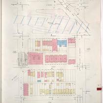
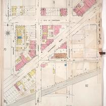
Sanborn Map, Kansas City, Vol. 1, 1909-1938, Page p073
-
Description
-
A portion of Kansas City from W. 20th Street south to Southwest Boulevard and from Pennsylvania Avenue east to Broadway, showing buildings, streets, and additions. Large numbers at edges of page refer to page with adjoining area.
-
Date
-
1909/1938
-
Object Type
-
Map
-

-
Title
-
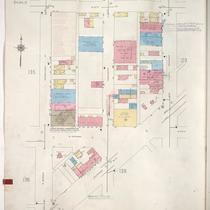
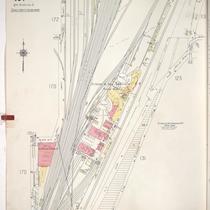
Sanborn Map, Kansas City, Vol. 1, 1909-1938, Page p082
-
Description
-
A portion of Kansas City from about W. 24th Street south to W. 25th Street and from Jefferson Street east to Broadway, showing buildings, streets, railroads, and additions. Large numbers at edges of page refer to page with adjoining area.
-
Date
-
1909/1938
-
Object Type
-
Map
-

-
Title
-
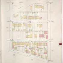
Sanborn Map, Kansas City, Vol. 1, 1909-1938, Page p071
-
Description
-
A portion of Kansas City from W. 20th Street south to W. Penn Way and from Madison Avenue east to Pennsylvania Avenue, showing buildings, streets, and additions. Large numbers at edges of page refer to page with adjoining area.
-
Date
-
1909/1938
-
Object Type
-
Map
-

-
Title
-
Sanborn Map, Kansas City, Vol. 1A, 1939-1949, Page p135
-
Description
-
A portion of Kansas City from W. 20th Street south to W. Pennway and from Madison Avenue east to Pennsylvania Avenue, showing buildings and streets. Large numbers at edges of page refer to page with adjoining area.
-
Date
-
1939/1949
-
Object Type
-
Map
-
-
Title
-
Sanborn Map, Kansas City, Vol. 1A, 1939-1949, Page p143
-
Description
-
A portion of Kansas City from W. 23rd Street Trafficway south to W. 24th Street and from Madison Avenue east to W. Pennway, showing buildings and streets. Large numbers at edges of page refer to page with adjoining area.
-
Date
-
1939/1949
-
Object Type
-
Map
-

-
Title
-
Sanborn Map, Kansas City, Vol. 1A, 1939-1949, Page p138
-
Description
-
A portion of Kansas City from W. Pennway south to W. 24th Street and from W. Pennway east to Broadway, showing buildings, railroads, and streets. Large numbers at edges of page refer to page with adjoining area.
-
Date
-
1939/1949
-
Object Type
-
Map
-

-
Title
-
Sanborn Map, Kansas City, Vol. 1A, 1939-1949, Page p144
-
Description
-
A portion of Kansas City from W. 24th Street south to W. 25th Street and from Madison Avenue east to W. Pennway, showing buildings, railroads, and streets. Large numbers at edges of page refer to page with adjoining area.
-
Date
-
1939/1949
-
Object Type
-
Map
-
-
Title
-
Sanborn Map, Kansas City, Vol. 1A, 1939-1949, Page p136
-
Description
-
A portion of Kansas City from W. 21st Street south to W. 23rd Street Trafficway and from Madison Avenue east to W. Pennway, showing buildings and streets. Large numbers at edges of page refer to page with adjoining area.
-
Date
-
1939/1949
-
Object Type
-
Map
-

-
Title
-
Sanborn Map, Kansas City, Vol. 1A, 1939-1949, Page p128
-
Description
-
A portion of Kansas City from W. 18th Street south to W. 20th Street and from Belleview Avenue east to Jefferson Street, showing buildings and streets. Large numbers at edges of page refer to page with adjoining area.
-
Date
-
1939/1949
-
Object Type
-
Map
-

-
Title
-
Sanborn Map, Kansas City, Vol. 1A, 1939-1949, Page p145
-
Description
-
A portion of Kansas City from W. 24th Street south to W. 25th Street and from W. Pennway east to Broadway, showing buildings, railroads, and streets. Large numbers at edges of page refer to page with adjoining area.
-
Date
-
1939/1949
-
Object Type
-
Map
-
-
Title
-
Sanborn Map, Kansas City, Vol. 1A, 1939-1949, Page p137
-
Description
-
A portion of Kansas City from W. 20th Street south to Southwest Boulevard and from W. Pennway east to Broadway, showing buildings and streets. Large numbers at edges of page refer to page with adjoining area.
-
Date
-
1939/1949
-
Object Type
-
Map
-

-
Title
-
Sanborn Map, Kansas City, Vol. 1A, 1939-1949, Page p148
-
Description
-
A portion of Kansas City from W. 25th Street south to W. 26th Street and from Madison Avenue east to W. Pennway, showing buildings and streets. Large numbers at edges of page refer to page with adjoining area.
-
Date
-
1939/1949
-
Object Type
-
Map
-
-
Title
-
Sanborn Map, Kansas City, Vol. 1A, 1939-1949, Page p126
-
Description
-
A portion of Kansas City from W. 18th Street south to W. 20th Street and from Mercier east to Belleview, showing buildings and streets. Large numbers at edges of page refer to page with adjoining area.
-
Date
-
1939/1949
-
Object Type
-
Map
-

-
Title
-
Sanborn Map, Kansas City, Vol. 1A, 1939-1949, Page p133
-
Description
-
A portion of Kansas City from W. 20th Street south to W. 21st Street and from Holly Street east to Madison Avenue, showing buildings and streets. Large numbers at edges of page refer to page with adjoining area.
-
Date
-
1939/1949
-
Object Type
-
Map
-

-
Title
-
Sanborn Map, Kansas City, Vol. 1A, 1939-1949, Page p147
-
Description
-
A portion of Kansas City from W. 25th Street south to W. 26th Street and from W. Pennway east to Central Street, showing buildings and streets. Large numbers at edges of page refer to page with adjoining area.
-
Date
-
1939/1949
-
Object Type
-
Map
-
-
Title
-
Sanborn Map, Kansas City, Vol. 1, 1909-1938, Page p083
-
Description
-
A portion of Kansas City from W. 25th Street south to W. 26th Street and from Jefferson east to Broadway, showing buildings, streets, and additions. Large numbers at edges of page refer to page with adjoining area.
-
Date
-
1909/1938
-
Object Type
-
Map
-
-
Title
-
Sanborn Map, Kansas City, Vol. 1, 1909-1938, Page p072
-
Description
-
A portion of Kansas City from W. 23rd Street Trafficway south to W. 24th Street and from Madison Avenue east to W. Penn Way, showing buildings, streets, and additions. Large numbers at edges of page refer to page with adjoining area.
-
Date
-
1909/1938
-
Object Type
-
Map
-
-
Title
-
Sanborn Map, Kansas City, Vol. 1A, 1939-1949, Page p167
-
Description
-
A portion of Kansas City from W. 17th Street south to W. 21st Street and from Wyoming east to Holly Street, showing buildings, railroads, and streets. Large numbers at edges of page refer to page with adjoining area.
-
Date
-
1939/1949
-
Object Type
-
Map
-

-
Title
-
Sanborn Map, Kansas City, Vol. 1A, 1939-1957, Page p133
-
Description
-
A portion of Kansas City from W. 20th Street south to W. 21st Street and from Holly Street east to Madison Avenue, showing buildings and streets. Large numbers at edges of page refer to page with adjoining area.
-
Date
-
1939/1957
-
Object Type
-
Map
Pages
