Pages
-
-
Title
-
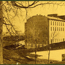
Coates Opera House
-
Description
-
View looking northeast of the rear of the Coates Opera House from about 10th and Washington streets in the Quality Hill area.
-
Date
-
1877
-
Object Type
-
Photograph
-

-
Title
-
Progress Club Building
-
Description
-
View of the Progress Club Building at 1021 Washington Street. Figures standing near the front entryway can be seen. A car parked on Washington Street is in view.
-
Date
-
1915
-
Object Type
-
Photograph
-

-
Title
-
Progress Club Building
-
Description
-
View looking northeast of the Progress Club Building located at 1021 Washington Street. Cars parked on the street can be seen.
-
Date
-
1989
-
Object Type
-
Photograph
-

-
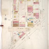
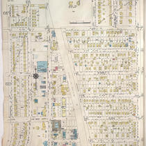
Title
-
Sanborn Map, Kansas City, Vol. 1, 1909-1938, Page p032
-
Description
-
A portion of Kansas City from W. 9th Street south to W. 11th Street and from Pennsylvania Avenue east to Broadway, showing buildings, streets, and additions. Large numbers at edges of page refer to page with adjoining area.
-
Date
-
1909/1938
-
Object Type
-
Map
-
-
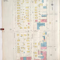
Title
-
Sanborn Map, Kansas City, Vol. 1, 1909-1938, Page p073
-
Description
-
A portion of Kansas City from W. 20th Street south to Southwest Boulevard and from Pennsylvania Avenue east to Broadway, showing buildings, streets, and additions. Large numbers at edges of page refer to page with adjoining area.
-
Date
-
1909/1938
-
Object Type
-
Map
-

-
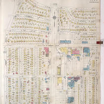
Title
-
Sanborn Map, Kansas City, Vol. 4, 1909-1957, Page p498
-
Description
-
A portion of Kansas City from W. 38th Street south to W. 40th Street and from Pennsylvania Avenue east to Broadway, showing buildings, streets, and additions. Large numbers at edges of page refer to page with adjoining area.
-
Date
-
1909/1957
-
Object Type
-
Map
-

-
Title
-
Sanborn Map, Kansas City, Vol. 1, 1909-1938, Page p082
-
Description
-
A portion of Kansas City from about W. 24th Street south to W. 25th Street and from Jefferson Street east to Broadway, showing buildings, streets, railroads, and additions. Large numbers at edges of page refer to page with adjoining area.
-
Date
-
1909/1938
-
Object Type
-
Map
-
-
Title
-
Sanborn Map, Kansas City, Vol. 9, 1930-1957, Page p1013
-
Description
-
A portion of Kansas City from W. 73rd Street south to W. 75th Street and from Pennsylvania Avenue east to Wornall Road, showing buildings, streets, and additions. Large numbers at edges of page refer to page with adjoining area.
-
Date
-
1930/1957
-
Object Type
-
Map
-

-
Title
-
Sanborn Map, Kansas City, Vol. 9, 1930-1957, Page p1002
-
Description
-
A portion of Kansas City from W. 63rd Street south to W. 66th Street Terrace and from Pennsylvania Avenue east to Baltimore Avenue, showing buildings, streets, and additions. Large numbers at edges of page refer to page with adjoining area.
-
Date
-
1930/1957
-
Object Type
-
Map
-

-
Title
-
Sanborn Map, Kansas City, Vol. 1A, 1939-1949, Page p104
-
Description
-
A portion of Kansas City from W. 7th Street south to W. 9th Street and from Washington Street east to Broadway, showing buildings and streets. Large numbers at edges of page refer to page with adjoining area.
-
Date
-
1939/1949
-
Object Type
-
Map
-
-
Title
-
Sanborn Map, Kansas City, Vol. 9, 1930-1957, Page p1008
-
Description
-
A portion of Kansas City from W. 70th Street south to W. 73rd Street and from Jefferson Street east to Baltimore Avenue, showing buildings, streets, and additions. Large numbers at edges of page refer to page with adjoining area. Country Club Lumber Company is noted on the map, but the 1939 city directory calls it the Snyder-Kunkel Lumber Company, 321 W. Gregory Blvd.
-
Date
-
1930/1957
-
Object Type
-
Map
-

-
Title
-
Sanborn Map, Kansas City, Vol. 9, 1930-1941, Page p1015
-
Description
-
A portion of Kansas City from W. 75th Street south to W. 76th Street and from Jefferson Street east to Wornall Road, showing buildings, streets, and additions. Large numbers at edges of page refer to page with adjoining area.
-
Date
-
1930/1941
-
Object Type
-
Map
-

-
Title
-
Sanborn Map, Kansas City, Vol. 9, 1930-1941, Page p1013
-
Description
-
A portion of Kansas City from W. 73rd Street south to W. 75th Street and from Pennsylvania Avenue east to Wornall Road, showing buildings, streets, and additions. Large numbers at edges of page refer to page with adjoining area.
-
Date
-
1930/1941
-
Object Type
-
Map
-

-
Title
-
Sanborn Map, Kansas City, Vol. 1A, 1939-1949, Page p103
-
Description
-
A portion of Kansas City from W. 7th Street south to W. 9th Street and from Jefferson east to Washington, showing buildings and streets. Large numbers at edges of page refer to page with adjoining area.
-
Date
-
1939/1949
-
Object Type
-
Map
-

-
Title
-
Sanborn Map, Kansas City, Vol. 1A, 1939-1949, Page p116
-
Description
-
A portion of Kansas City from W. 16th Street south to W. 17th Street and from Pennsylvania Avenue east to Broadway, showing buildings and streets. Large numbers at edges of page refer to page with adjoining area.
-
Date
-
1939/1949
-
Object Type
-
Map
-

-
Title
-
Sanborn Map, Kansas City, Vol. 1A, 1939-1949, Page p129
-
Description
-
A portion of Kansas City from W. 17th Street south to W. 18th Street and from Jefferson Street east to Broadway, showing buildings and streets. Large numbers at edges of page refer to page with adjoining area.
-
Date
-
1939/1949
-
Object Type
-
Map
-
-
Title
-
Sanborn Map, Kansas City, Vol. 9, 1930-1957, Page p1023
-
Description
-
A portion of Kansas City from W. 77th Street south to W. 79th Street Terrace and from Pennsylvania Avenue east to Main Street, showing buildings, streets, and additions. Large numbers at edges of page refer to page with adjoining area. At top of map, "A. May 1941."
-
Date
-
1930/1957
-
Object Type
-
Map
-

-
Title
-
Sanborn Map, Kansas City, Vol. 9, 1930-1957, Page p1015
-
Description
-
A portion of Kansas City from W. 75th Street south to W. 76th Street and from Jefferson Street east to Wornall Road, showing buildings, streets, and additions. Large numbers at edges of page refer to page with adjoining area.
-
Date
-
1930/1957
-
Object Type
-
Map
-

-
Title
-
Sanborn Map, Kansas City, Vol. 1A, 1939-1949, Page p138
-
Description
-
A portion of Kansas City from W. Pennway south to W. 24th Street and from W. Pennway east to Broadway, showing buildings, railroads, and streets. Large numbers at edges of page refer to page with adjoining area.
-
Date
-
1939/1949
-
Object Type
-
Map
-

-
Title
-
Sanborn Map, Kansas City, Vol. 1, 1909-1938, Page p074
-
Description
-
A portion of Kansas City from Southwest Boulevard south to W. 23rd Street and from West Penn Way east to Broadway, showing buildings, streets, and additions. Large numbers at edges of page refer to page with adjoining area.
-
Date
-
1909/1938
-
Object Type
-
Map
Pages
