Pages
-
-
Title
-
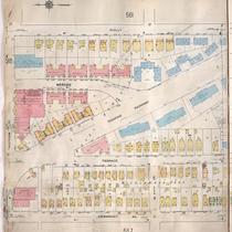
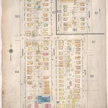
Sanborn Map, Kansas City, Vol. 4, 1909-1950, Page p559
-
Description
-
A portion of Kansas City from Westport Road south to W. 44th Street and from Fairmount Avenue east to Holly Street, showing buildings, streets, and additions. Large numbers at edges of page refer to page with adjoining area.
-
Date
-
1909/1950
-
Object Type
-
Map
-
-
Title
-
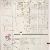
Sanborn Map, Kansas City, Vol. 5, 1940-1941, Page p1236
-
Description
-
A portion of Kansas City from E. 18th Street south to E. 20th Street and from Bennington Avenue east to Winchester Avenue and a portion from E. 24th Street south to E. 27th Street and Lawndale Avenue east to Belmont Avenue, showing buildings and streets. Large numbers at edges of page refer to page with adjoining area. Indicated at top of sheet that this page number corresponds with pages 751 and 756 in Vol. 6.
-
Date
-
1940/1941
-
Object Type
-
Map
-
-
Title
-
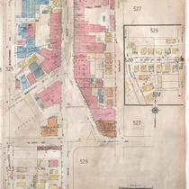
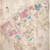
Sanborn Map, Kansas City, Vol. 4, 1909-1950, Page p526
-
Description
-
A portion of Kansas City from E. 39th Street south to E. 40th Street and from Baltimore Avenue east to Walnut Street, showing buildings, streets, and additions. Large numbers at edges of page refer to page with adjoining area.
-
Date
-
1909/1950
-
Object Type
-
Map
-

-
Title
-
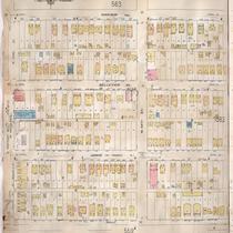
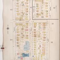
Sanborn Map, Kansas City, Vol. 4, 1909-1950, Page p554
-
Description
-
A portion of Kansas City from W. 42nd Street south to Westport Road and from State Line east to Terrace, showing buildings, streets, and additions. Large numbers at edges of page refer to page with adjoining area.
-
Date
-
1909/1950
-
Object Type
-
Map
-
-
Title
-
Sanborn Map, Kansas City, Vol. 4, 1909-1950, Page p561
-
Description
-
A portion of Kansas City from W. 43rd Street south to W. 44th Street and from Holly Street east to Madison Avenue, showing buildings, streets, and additions. Large numbers at edges of page refer to page with adjoining area.
-
Date
-
1909/1950
-
Object Type
-
Map
-

-
Title
-
Sanborn Map, Kansas City, Vol. 4, 1909-1950, Page p525
-
Description
-
A portion of Kansas City from W. 39th Street south to Westport Road and from Broadway east to Baltimore Avenue, showing buildings, streets, and additions. Large numbers at edges of page refer to page with adjoining area.
-
Date
-
1909/1950
-
Object Type
-
Map
-

-
Title
-
Sanborn Map, Kansas City, Vol. 4, 1909-1950, Page p522
-
Description
-
A portion of Kansas City from Westport Road south to W. 43rd Street and from Pennsylvania Avenue east to Wornall Road, showing buildings, streets, and additions. Large numbers at edges of page refer to page with adjoining area.
-
Date
-
1909/1950
-
Object Type
-
Map
-
-
Title
-
Sanborn Map, Kansas City, Vol. 4, 1909-1950, Page p555
-
Description
-
A portion of Kansas City from W. 41st Street south to Westport Road and from Terrace east to Holly Street, showing buildings, streets, and additions. Large numbers at edges of page refer to page with adjoining area.
-
Date
-
1909/1950
-
Object Type
-
Map
-
-
Title
-
Sanborn Map, Kansas City, Vol. 4, 1909-1950, Page p523
-
Description
-
A portion of Kansas City from W. 40th Street south to Filmore Street and from Pennsylvania Avenue east to Baltimore Avenue, showing buildings, streets, and additions. Large numbers at edges of page refer to page with adjoining area.
-
Date
-
1909/1950
-
Object Type
-
Map
-

-
Title
-
Sanborn Map, Kansas City, Vol. 4, 1909-1950, Page p518
-
Description
-
A portion of Kansas City from W. 42nd Street south to W. 43rd Street and from Holly Street east to Roanoke Road, showing buildings, streets, and additions. Large numbers at edges of page refer to page with adjoining area.
-
Date
-
1909/1950
-
Object Type
-
Map
-

-
Title
-
Sanborn Map, Kansas City, Vol. 4, 1909-1950, Page p521
-
Description
-
A portion of Kansas City from W. 40th Street south to Westport Road and from Waddell Avenue east to Washington Street, showing buildings, streets, and additions. Large numbers at edges of page refer to page with adjoining area.
-
Date
-
1909/1950
-
Object Type
-
Map
-

-
Title
-
Sanborn Map, Kansas City, Vol. 5, 1940-1941, Page p1241
-
Description
-
A portion of Kansas City from E. 27th Street south to E. 31st Street and from Oakley Avenue east to Belmont Avenue, showing buildings and streets. Large numbers at edges of page refer to page with adjoining area. Indicated at top of sheet that this page number corresponds with page 726 in Vol. 6.
-
Date
-
1940/1941
-
Object Type
-
Map
-

-
Title
-
Sanborn Map, Kansas City, Vol. 3, 1909-1957, Page p341
-
Description
-
A portion of Kansas City from E. 21st Street south to E. 23rd Street and from Main Street east to McGee, showing buildings, streets, and additions. Large numbers at edges of page refer to page with adjoining area.
-
Date
-
1909/1957
-
Object Type
-
Map
-
-
Title
-
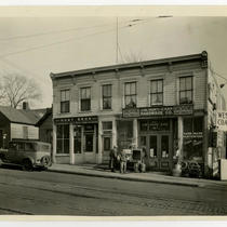
J. W. Hunt Hardware Store at 523 Westport Road
-
Description
-
View looking southeast of the J. W. Hunt Hardware Store that once stood at 521-523 Westport Road. A car and two individuals can be seen outside of the store.
-
Date
-
1940~
-
Object Type
-
Photograph
-
-
Title
-
Sanborn Map, Kansas City, Vol. 4, 1909-1957, Page p555
-
Description
-
A portion of Kansas City from W. 41st Street south to Westport Road and from Terrace east to Holly, showing buildings, streets, and additions. Large numbers at edges of page refer to page with adjoining area.
-
Date
-
1909/1957
-
Object Type
-
Map
-

-
Title
-
Sanborn Map, Kansas City, Vol. 4, 1909-1957, Page p521
-
Description
-
A portion of Kansas City from W. 40th Street south to Westport Road and from Waddell Avenue east to Washington, showing buildings, streets, and additions. Large numbers at edges of page refer to page with adjoining area.
-
Date
-
1909/1957
-
Object Type
-
Map
-

-
Title
-
Sanborn Map, Kansas City, Vol. 4, 1909-1957, Page p525
-
Description
-
A portion of Kansas City from W. 39th Street south to W. 40th Street and from Broadway east to Baltimore Avenue, showing buildings, streets, and additions. Large numbers at edges of page refer to page with adjoining area.
-
Date
-
1909/1957
-
Object Type
-
Map
-

-
Title
-
Sanborn Map, Kansas City, Vol. 3, 1896-1907, Page p292
-
Description
-
Southeastern part of early Kansas City from E. 24th Street south to E. 25th Street and from Main Street east to McGee Street, showing buildings, streets, and additions. Large numbers at edges of page refer to page with adjoining area.
-
Date
-
1896/1907
-
Object Type
-
Map
-

-
Title
-
Sanborn Map, Kansas City, Vol. 3, 1896-1907, Page p291
-
Description
-
Southeastern part of early Kansas City from E. 22nd Street south to E. 24th Street and from Main Street east to McGee Street, showing buildings, streets, and railroad lines. Large numbers at edges of page refer to page with adjoining area.
-
Date
-
1896/1907
-
Object Type
-
Map
-

-
Title
-
Sanborn Map, Kansas City, Vol. 4, 1909-1957, Page p554
-
Description
-
A portion of Kansas City from W. 42nd Street south to Westport Road and from State Line east to Terrace, showing buildings, streets, and additions. Large numbers at edges of page refer to page with adjoining area.
-
Date
-
1909/1957
-
Object Type
-
Map
Pages
