-
-
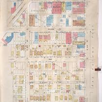
Title
-
Sanborn Map, Kansas City, Vol. 3, 1909-1957, Page p394
-
Description
-
A portion of Kansas City from E. 30th Street south to E. 31st Street and from McGee Street east to McGee Street Trafficway (Cherry), showing buildings, streets, and additions. Large numbers at edges of page refer to page with adjoining area.
-
Date
-
1909/1957
-
Object Type
-
Map
-
-
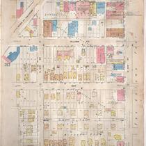
Title
-
Sanborn Map, Kansas City, Vol. 3, 1909-1950, Page p394
-
Description
-
A portion of Kansas City from E. 30th Street south to E. 31st Street and from McGee Street east to McGee Street Trafficway (Cherry), showing buildings, streets, and additions. Large numbers at edges of page refer to page with adjoining area.
-
Date
-
1909/1950
-
Object Type
-
Map
-
-
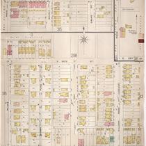
Title
-
Sanborn Map, Kansas City, Vol. 3, 1896-1907, Page p316
-
Description
-
Southeastern part of early Kansas City from E. 30th Street south to E. 31st Street and from McGee Street east to Gillham Road, as well as a portion of E. 29th Street from Main Street east to Grand Avenue, showing buildings, streets, and additions. Large numbers at edges of page refer to page with the adjoining area.
-
Date
-
1896/1907
-
Object Type
-
Map
