-

-
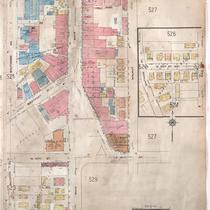
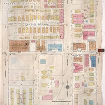
Title
-
Sanborn Map, Kansas City, Vol. 4, 1909-1950, Page p527
-
Description
-
A portion of Kansas City from E. 39th Street south to E. 40th Street and from Walnut Street east to Locust Street, showing buildings, streets, and additions. Large numbers at edges of page refer to page with adjoining area.
-
Date
-
1909/1950
-
Object Type
-
Map
-

-
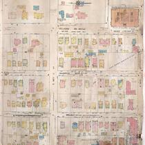
Title
-
Sanborn Map, Kansas City, Vol. 4, 1909-1950, Page p500
-
Description
-
A portion of Kansas City from W. 38th Street south to W. 39th Street and from Broadway east to Main Street, showing buildings, streets, and additions. Large numbers at edges of page refer to page with adjoining area.
-
Date
-
1909/1950
-
Object Type
-
Map
-
-
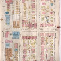
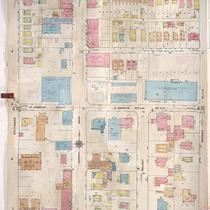
Title
-
Sanborn Map, Kansas City, Vol. 4, 1909-1950, Page p526
-
Description
-
A portion of Kansas City from E. 39th Street south to E. 40th Street and from Baltimore Avenue east to Walnut Street, showing buildings, streets, and additions. Large numbers at edges of page refer to page with adjoining area.
-
Date
-
1909/1950
-
Object Type
-
Map
-
-
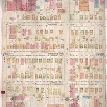
Title
-
Sanborn Map, Kansas City, Vol. 4, 1909-1950, Page p502
-
Description
-
A portion of Kansas City from E. 38th Street south to E. 39th Street and from Main Street east to Locust Street, showing buildings, streets, and additions. Large numbers at edges of page refer to page with adjoining area.
-
Date
-
1909/1950
-
Object Type
-
Map
-
-
Title
-
Sanborn Map, Kansas City, Vol. 4, 1909-1957, Page p476
-
Description
-
A portion of Kansas City from W. 34th Street south to W. 36th Street and from Broadway east to Baltimore Avenue, showing buildings, streets, and additions. Large numbers at edges of page refer to page with adjoining area.
-
Date
-
1909/1957
-
Object Type
-
Map
-
-
Title
-
Sanborn Map, Kansas City, Vol. 4, 1909-1957, Page p499
-
Description
-
A portion of Kansas City from W. 36th Street south to W. 37th Street and from Broadway east to Main Street, showing buildings, streets, and additions. Large numbers at edges of page refer to page with adjoining area.
-
Date
-
1909/1957
-
Object Type
-
Map
-
-
Title
-
Sanborn Map, Kansas City, Vol. 4, 1909-1957, Page p501
-
Description
-
A portion of Kansas City from W. 36th Street south to W. 37th Street and from Main Street east to Locust Street, showing buildings, streets, and additions. Large numbers at edges of page refer to page with adjoining area.
-
Date
-
1909/1957
-
Object Type
-
Map
-
-
Title
-
Sanborn Map, Kansas City, Vol. 4, 1909-1957, Page p478
-
Description
-
A portion of Kansas City from E. 34th Street south to E. 36th Street and from Warwick Boulevard east to Locust, showing buildings, streets, and additions. Large numbers at edges of page refer to page with adjoining area.
-
Date
-
1909/1957
-
Object Type
-
Map
-

-
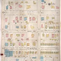
Title
-
Sanborn Map, Kansas City, Vol. 4, 1909-1950, Page p525
-
Description
-
A portion of Kansas City from W. 39th Street south to Westport Road and from Broadway east to Baltimore Avenue, showing buildings, streets, and additions. Large numbers at edges of page refer to page with adjoining area.
-
Date
-
1909/1950
-
Object Type
-
Map
-

-
Title
-
Sanborn Map, Kansas City, Vol. 4, 1909-1950, Page p499
-
Description
-
A portion of Kansas City from W. 36th Street south to W. 37th Street and from Broadway east to Main Street, showing buildings, streets, and additions. Large numbers at edges of page refer to page with adjoining area.
-
Date
-
1909/1950
-
Object Type
-
Map
-
-
Title
-
Sanborn Map, Kansas City, Vol. 4, 1909-1957, Page p477
-
Description
-
A portion of Kansas City from W. 34th Street south to W. 36th Street and from Baltimore Avenue east to Warwick Boulevard, showing buildings, streets, and additions. Large numbers at edges of page refer to page with adjoining area.
-
Date
-
1909/1957
-
Object Type
-
Map
-

-
Title
-
Sanborn Map, Kansas City, Vol. 4, 1909-1950, Page p501
-
Description
-
A portion of Kansas City from E. 36th Street south to E. 37th Street and from Main Street east to Locust Street, showing buildings, streets, and additions. Large numbers at edges of page refer to page with adjoining area.
-
Date
-
1909/1950
-
Object Type
-
Map
