-
-
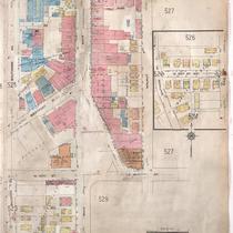
Title
-
Sanborn Map, Kansas City, Vol. 4, 1909-1950, Page p526
-
Description
-
A portion of Kansas City from E. 39th Street south to E. 40th Street and from Baltimore Avenue east to Walnut Street, showing buildings, streets, and additions. Large numbers at edges of page refer to page with adjoining area.
-
Date
-
1909/1950
-
Object Type
-
Map
-

-
Title
-
Sanborn Map, Kansas City, Vol. 1, 1895-1907, Page p089
-
Description
-
Southern part of early Kansas City in the Hyde Park area on the outskirts of Westport from W. 39th Street south to Westport Avenue and from Central Street east to Main Street, showing buildings, streets, and additions. Large numbers at edges of page refer to page with adjoining area.
-
Date
-
1895/1907
-
Object Type
-
Map
