Pages
-

-
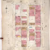
Title
-
Sanborn Map, Kansas City, Vol. 2, 1909-1937, Page p229
-
Description
-
A portion of Kansas City from E. 11th Street south to E. 13th Street and from Oak Street east to Cherry Street, showing buildings, streets, and additions. Large numbers at edges of page refer to page with adjoining area.
-
Date
-
1909/1937
-
Object Type
-
Map
-

-
Title
-
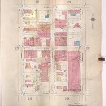
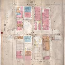
Sanborn Map, Kansas City, Vol. 2, 1909-1937, Page p242
-
Description
-
A portion of Kansas City from E. 13th Street south to E. 15th Street and from Grand Avenue east to Oak Street, showing buildings, streets, and additions. Large numbers at edges of page refer to page with adjoining area.
-
Date
-
1909/1937
-
Object Type
-
Map
-
-
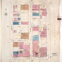
Title
-
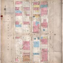
Sanborn Map, Kansas City, Vol. 2, 1909-1937, Page p241
-
Description
-
A portion of Kansas City from E. 13th Street south to E. 15th Street and from Main Street east to Grand Avenue, showing buildings, streets, and additions. Large numbers at edges of page refer to page with adjoining area.
-
Date
-
1909/1937
-
Object Type
-
Map
-
-
Title
-
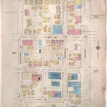
Sanborn Map, Kansas City, Vol. 1, 1909-1938, Page p062
-
Description
-
A portion of Kansas City from W. 16th Street south to W. 18th Street and from Wyandotte east to Main Street, showing buildings, streets, and additions. Large numbers at edges of page refer to page with adjoining area.
-
Date
-
1909/1938
-
Object Type
-
Map
-
-
Title
-
Sanborn Map, Kansas City, Vol. 3, 1909-1957, Page p302
-
Description
-
A portion of Kansas City from Truman Road south to E. 17th Street and from Grand Avenue east to Locust, showing buildings, streets, and additions. Large numbers at edges of page refer to page with adjoining area.
-
Date
-
1909/1957
-
Object Type
-
Map
-

-
Title
-
Sanborn Map, Kansas City, Vol. 3, 1909-1957, Page p314
-
Description
-
A portion of Kansas City from E. 17th Street south to E. 19th Street and from Grand Avenue east to Locust, showing buildings, streets, and additions. Large numbers at edges of page refer to page with adjoining area.
-
Date
-
1909/1957
-
Object Type
-
Map
-
-
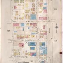
Title
-
Sanborn Map, Kansas City, Vol. 4, 1909-1957, Page p498
-
Description
-
A portion of Kansas City from W. 38th Street south to W. 40th Street and from Pennsylvania Avenue east to Broadway, showing buildings, streets, and additions. Large numbers at edges of page refer to page with adjoining area.
-
Date
-
1909/1957
-
Object Type
-
Map
-

-
Title
-
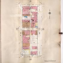
Sanborn Map, Kansas City, Vol. 3, 1909-1957, Page p313
-
Description
-
A portion of Kansas City from E. 17th Street south to E. 19th Street and from Main Street east to Grand Avenue, showing buildings, streets, and additions. Large numbers at edges of page refer to page with adjoining area.
-
Date
-
1909/1957
-
Object Type
-
Map
-
-
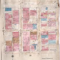
Title
-
Sanborn Map, Kansas City, Vol. 3, 1909-1950, Page p301
-
Description
-
A portion of Kansas City from Truman Road south to E. 17th Street and from Main Street east to Grand Avenue, showing buildings, streets, and additions. Large numbers at edges of page refer to page with adjoining area.
-
Date
-
1909/1950
-
Object Type
-
Map
-

-
Title
-
Sanborn Map, Kansas City, Vol. 1, 1909-1938, Page p064
-
Description
-
A portion of Kansas City from W. 18th Street south to W. 20th Street and from Wyandotte Street east to Main Street, showing buildings, streets, and additions. Large numbers at edges of page refer to page with adjoining area.
-
Date
-
1909/1938
-
Object Type
-
Map
-

-
Title
-
Sanborn Map, Kansas City, Vol. 1, 1909-1938, Page p054
-
Description
-
A portion of Kansas City from W. 14th Street south to W. 16th Street and from Wyandotte east to Main, showing buildings, streets, and additions. Large numbers at edges of page refer to page with adjoining area.
-
Date
-
1909/1938
-
Object Type
-
Map
-
-
Title
-
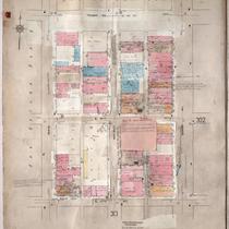
Sanborn Map, Kansas City, Vol. 2, 1909-1937, Page p226
-
Description
-
A portion of Kansas City from E. 11th Street south to E. 13th Street and from Walnut Street east to Grand Avenue, showing buildings, streets, and additions. Large numbers at edges of page refer to page with adjoining area.
-
Date
-
1909/1937
-
Object Type
-
Map
-

-
Title
-
Sanborn Map, Kansas City, Vol. 2, 1909-1937, Page p227
-
Description
-
A portion of Kansas City from E. 11th Street south to E. 13th Street and from Grand Avenue east to McGee Street, showing buildings, streets, and additions. Large numbers at edges of page refer to page with adjoining area.
-
Date
-
1909/1937
-
Object Type
-
Map
-
-
Title
-
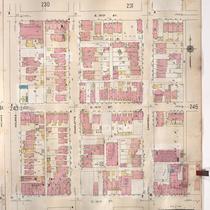
Sanborn Map, Kansas City, Vol. 2, 1909-1937, Page p230
-
Description
-
A portion of Kansas City from E. 11th Street south to E. 13th Street and from Cherry Street east to Charlotte Street, showing buildings, streets, and additions. Large numbers at edges of page refer to page with adjoining area.
-
Date
-
1909/1937
-
Object Type
-
Map
-
-
Title
-
Sanborn Map, Kansas City, Vol. 2, 1909-1937, Page p228
-
Description
-
A portion of Kansas City from E. 11th Street south to E. 13th Street and from McGee Street east to Oak Street, showing buildings, streets, and additions. Large numbers at edges of page refer to page with adjoining area.
-
Date
-
1909/1937
-
Object Type
-
Map
-
-
Title
-
Sanborn Map, Kansas City, Vol. 2, 1909-1937, Page p244
-
Description
-
A portion of Kansas City from E. 13th Street south to E. 15th Street and from Holmes Street east to Campbell, showing buildings, streets, and additions. Large numbers at edges of page refer to page with adjoining area.
-
Date
-
1909/1937
-
Object Type
-
Map
-
-
Title
-
Sanborn Map, Kansas City, Vol. 3, 1909-1950, Page p327
-
Description
-
A portion of Kansas City from E. 19th Street south to E. 21st Street and from Main Street east to Grand Avenue, showing buildings, streets and additions. Large numbers at edges of page refer to page with adjoining area.
-
Date
-
1909/1950
-
Object Type
-
Map
-
-
Title
-
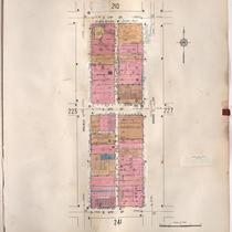
Sanborn Map, Kansas City, Vol. 3, 1909-1950, Page p313
-
Description
-
A portion of Kansas City from E. 17th Street south to E. 19th Street and from Main Street east to Grand Avenue, showing buildings, streets, and additions. Large numbers at edges of page refer to page with adjoining area.
-
Date
-
1909/1950
-
Object Type
-
Map
-
-
Title
-
Sanborn Map, Kansas City, Vol. 4, 1909-1950, Page p498
-
Description
-
A portion of Kansas City from W. 38th Street south to W. 40th Street and from Pennsylvania Avenue east to Broadway, showing buildings, streets, and additions. Large numbers at edges of page refer to page with adjoining area.
-
Date
-
1909/1950
-
Object Type
-
Map
-

-
Title
-
Sanborn Map, Kansas City, Vol. 3, 1909-1950, Page p314
-
Description
-
A portion of Kansas City from E. 17th Street south to E. 19th Street and from Grand Avenue east to Locust, showing buildings, streets, and additions. Large numbers at edges of page refer to page with adjoining area.
-
Date
-
1909/1950
-
Object Type
-
Map
Pages
