-

-
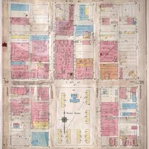
Title
-
Sanborn Map, Kansas City, Vol. 3, 1909-1957, Page p314
-
Description
-
A portion of Kansas City from E. 17th Street south to E. 19th Street and from Grand Avenue east to Locust, showing buildings, streets, and additions. Large numbers at edges of page refer to page with adjoining area.
-
Date
-
1909/1957
-
Object Type
-
Map
-

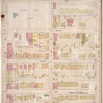
-
Title
-
Sanborn Map, Kansas City, Vol. 3, 1909-1950, Page p329
-
Description
-
A portion of Kansas City from E. 19th Street south to E. 21st Street and from Locust east to Charlotte, showing buildings, streets, and additions. Large numbers at edges of page refer to page with adjoining area.
-
Date
-
1909/1950
-
Object Type
-
Map
-

-
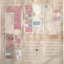
Title
-
Sanborn Map, Kansas City, Vol. 3, 1909-1950, Page p314
-
Description
-
A portion of Kansas City from E. 17th Street south to E. 19th Street and from Grand Avenue east to Locust, showing buildings, streets, and additions. Large numbers at edges of page refer to page with adjoining area.
-
Date
-
1909/1950
-
Object Type
-
Map
-
-
Title
-
Sanborn Map, Kansas City, Vol. 3, 1909-1950, Page p315
-
Description
-
A portion of Kansas City from E. 17th Street south to E. 19th Street and from Locust east to Charlotte, showing buildings, streets and additions. Large numbers at edges of page refer to page with adjoining area.
-
Date
-
1909/1950
-
Object Type
-
Map
-
-
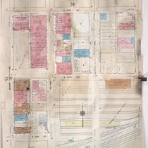
Title
-
Sanborn Map, Kansas City, Vol. 3, 1909-1957, Page p328
-
Description
-
A portion of Kansas City from E. 19th Street south to E. 21st Street and from Grand Avenue east to Locust, showing buildings, streets, and additions. Large numbers at edges of page refer to page with adjoining area.
-
Date
-
1909/1957
-
Object Type
-
Map
-
-
Title
-
Sanborn Map, Kansas City, Vol. 3, 1909-1950, Page p328
-
Description
-
A portion of Kansas City from E. 19th Street south to E. 21st Street and from Grand Avenue east to Locust, showing buildings, streets, and additions. Large numbers at edges of page refer to page with adjoining area.
-
Date
-
1909/1950
-
Object Type
-
Map
-
-
Title
-
Sanborn Map, Kansas City, Vol. 4, 1909-1950, Page p496
-
Description
-
A portion of Kansas City from Valentine Road south to W. 38th Street and from Jefferson Street east to Broadway, showing buildings, streets, and additions. Large numbers at edges of page refer to page with adjoining area.
-
Date
-
1909/1950
-
Object Type
-
Map
-

-
Title
-
Sanborn Map, Kansas City, Vol. 3, 1909-1957, Page p315
-
Description
-
A portion of Kansas City from E. 17th Street south to E. 19th Street and from Locust east to Charlotte, showing buildings, streets, and additions. Large numbers at edges of page refer to page with adjoining area.
-
Date
-
1909/1957
-
Object Type
-
Map
-

-
Title
-
Sanborn Map, Kansas City, Vol. 3, 1909-1957, Page p329
-
Description
-
A portion of Kansas City from E. 19th Street south to E. 21st Street and from Locust east to Charlotte, showing buildings, streets, and additions. Large numbers at edges of page refer to page with adjoining area.
-
Date
-
1909/1957
-
Object Type
-
Map
-
-
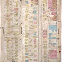
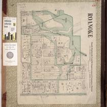
Title
-
Sanborn Map, Kansas City, Vol. 1, 1895-1907, Page f001
-
Description
-
Map of Roanoke residential district of Kansas City, developed by the Roanoke Investment Company from 1900 to 1920, showing buildings, streets, Roanoke Park, and Norman School. Attached to back of front cover.
-
Date
-
1895/1907
-
Object Type
-
Map
-
-
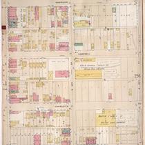
Title
-
Sanborn Map, Kansas City, Vol. 3, 1896-1907, Page p255
-
Description
-
Southeastern part of early Kansas City from E. 18th Street south to E. 20th Street and from Holmes Street east to Harrison Street, showing buildings, streets, and additions. Large numbers at edges of page refer to page with adjoining area.
-
Date
-
1896/1907
-
Object Type
-
Map
-
-
Title
-
Sanborn Map, Kansas City, Vol. 3, 1896-1907, Page p253
-
Description
-
Southeastern part of early Kansas City from E. 18th Street south to E. 20th Street and from McGee Street east to Holmes Street, showing buildings, streets, and additions. Large numbers at edges of page refer to page with adjoining area.
-
Date
-
1896/1907
-
Object Type
-
Map
