-
-
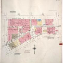
Title
-
Sanborn Map, Kansas City, Vol. 1A, 1939-1949, Page p176
-
Description
-
A portion of Kansas City from W. 9th Street south to Saint Louis Avenue and from Wyoming east to Hickory, showing buildings and streets. Large numbers at edges of page refer to page with adjoining area.
-
Date
-
1939/1949
-
Object Type
-
Map
-

-
Title
-
Sanborn Map, Kansas City, Vol. 1, 1909-1938, Page p026
-
Description
-
A portion of Kansas City from W. 9th Street south to W. 11th Street and from Wyoming east to Hickory, showing buildings, streets, railroads, and additions. Large numbers at edges of page refer to page with adjoining area.
-
Date
-
1909/1938
-
Object Type
-
Map
